Raipur district

Last updated
Raipur district
Raipur International Airport- New Terminal2.JPG
Balakrishnalalji mandir2.JPG
Arang Bhand dewal temple.jpg
Nawagaon Brick temple Chhattisgarh Sept 2022 - 33.jpg
Raipur Skyline in 2019.png
Clockwise from top-left: Swami Vivekananda Airport, Balakrishnaji Mandir in Champaran, Temples in Nawagaon, Roads of Raipur, Arang Bhand Dewal Temple
Raipur in Chhattisgarh (India).svg
Location in Chhattisgarh
Coordinates(Raipur): 20°55′N82°00′E / 20.917°N 82.000°E / 20.917; 82.000
CountryFlag of India.svg  India
State Chhattisgarh
DivisionRaipur
Headquarters Raipur
Area
  Total2,891.98 km2 (1,116.60 sq mi)
Population
 (2011)
  Total2,160,876
  Density750/km2 (1,900/sq mi)
Demographics
Average annual precipitation1385 mm
Website raipur.nic.in

Raipur district is a district in the Chhattisgarh state of India. Its administrative headquarters is the city of Raipur. The district is rich in mineral resources and there are many wildlife sanctuaries. With a population of 2 million, it is the most populous district of Chhattisgarh.

Contents

History

Raipur district, like the rest of the Chhattisgarh plain, was once known as Dakshina Kosala and considered to be under Maurya Empire. In Arang near Raipur, a Gupta inscription dated to the 6th century CE shows Gupta hegemony over the region. In the 7th century CE, the region was ruled by a Buddhist kingdom in Bhandak in modern-day Maharashtra and was described by Xuanzang. A branch of this family later migrated to Sirpur in present-day Mahasamund district, and later took control of the entirety of Dakshina Kosala. This kingdom's prosperity reached its height with Tivaradeva. His son inscribed almost all temples in Sirpur. They were later ousted by the Sharabpuriyas, who took control of the rest of Chhattisgarh and ruled for several centuries.

The Haihayas or Kalachuris, who claimed descent from the Chedis, later took control of the region in the early 9th century. The Haihaiya ruled Mughatunga was the first of the dynasty to rule Chhattisgarh, and his grandson set up the capital in Ratanpur, modern Bilaspur district. Their territory included modern Raipur. The Kalachuris controlled the region from Ratanpur the next three centuries, building many temples throughout their kingdom. By the 12th century, many small portions of their realm were given as fiefdoms to minor princes of the family and their power declined. The Haihaiyas of the Raipur branch then began to gain strength: one of their kings conquered 18 garh, or forts, of the enemy - lending an etymology to Chhattisgarh, the 36 forts. They ruled until the reign of Amar Singh Deva in 1741.

In the mid-16th century, Kalyan Singh, current ruler of Raipur, took audience with Akbar and was rewarded with the title of Raja and other high titles. This was the first Muslim influence in Chhattisgarh, which would always remain limited. By the early 18th century, the Kalachuris had become the overlords of a large number of divided petty chiefdoms, but with little authority. The Kalachuri ruler Raghunath Singh was the final independent ruler from Ratanpur, and in 1740 the Maratha general Bhaskar Pant invaded the region. A despondent, heirless Singh did not put up much resistance, and the Marathas took the region with little loss. Raghunath Singh continued ruling as a Maratha vassal. In 1745, Raghunath Singh died and Pant installed Mohan Singh, a loyal Maratha vassal from the dynasty, on the throne, where he ruled until 1758 when his son Bhimbaji took control with Maratha support. Bhimbaji ruled virtually independently of Nagpur, but his brother Venkoji who succeeded him was far less interested in administration than Nagpur court politics. Although a subah, a governor, was appointed by Venkoji to administer the region for him, this was resisted and real administration of the region was done by Bhimaji's widow Anandi Bai and a council of ministers. After Anandi Bai's death in the early 19th century, the region was ruled by a series of governors under a very loose control of Nagpur and often exploited the office to become rich. After the Third Anglo-Maratha war in 1818, a British colonel administered the region. British accounts claim the people were 'oppressed' by the Marathas, especially their pindari raids. The country returned to rule by subahs from Nagpur in 1830, but Raipur was too remote to have much contact with the government. This continued until the annexation of Nagpur under the Doctrine of Lapse in 1854. [1]

Amar Singh, the ruler of Raipur, continued ruling without Maratha interference until 1750. On his death, the Maratha government confiscated his holdings but later returned it to his son, whose family continued to hold revenue rights until Independence. [1]

Geography

It is situated between 22° 33' N to 21°14'N Latitude and 82° 6' to 81° 38'E Longitude. It occupies the south eastern part of the upper Mahanadi River valley and the bordering hills in the south and the east. The district is located on the Chhattisgarh plain, the areas near the hills being split off when the district was trifurcated.

The district borders Baloda Bazar district to the north, Mahasamund district to the east, Gariaband and Dhamtari districts to the south, and Durg and Bemetara districts to the west.

The Mahanadi River is the principal river of this district.

Raipur
Climate chart (explanation)
J
F
M
A
M
J
J
A
S
O
N
D
 
 
6.7
 
 
28
13
 
 
12
 
 
31
17
 
 
25
 
 
36
21
 
 
16
 
 
40
25
 
 
19
 
 
42
28
 
 
190
 
 
37
27
 
 
381
 
 
31
24
 
 
345
 
 
30
24
 
 
230
 
 
31
24
 
 
54
 
 
32
22
 
 
7.4
 
 
30
17
 
 
3.7
 
 
27
13
Average max. and min. temperatures in °C
Precipitation totals in mm
Source: IMD
Imperial conversion
JFMAMJJASOND
 
 
0.3
 
 
82
56
 
 
0.5
 
 
88
62
 
 
1
 
 
96
69
 
 
0.6
 
 
103
78
 
 
0.7
 
 
108
83
 
 
7.5
 
 
99
80
 
 
15
 
 
87
75
 
 
14
 
 
86
75
 
 
9.1
 
 
88
75
 
 
2.1
 
 
89
71
 
 
0.3
 
 
85
62
 
 
0.1
 
 
81
56
Average max. and min. temperatures in °F
Precipitation totals in inches

Divisions

Raipur district is administratively divided into 4 Tehsils and 4 development blocks. It comprises one Lok Sabha Constituency (Raipur) and 9 Vidhan Sabha (Chhattisgarh Assembly) constituencies. The chief crop of this region is paddy. There are more than 50 large and middle scale industries in this district which have offered employment to over 10,000 people.

Villages

• Sejbahar

Demographics

According to the 2011 census Raipur district has a population of 2,160,876. This gives it a ranking of 211th in India (out of a total of 640). The district has a population balls density of 750 inhabitants per square kilometre (1,900/sq mi) . Its population growth rate over the decade 2001-2011 was 34.65%. Raipur has a sex ratio of 983 females for every 1000 males, and a literacy rate of 76.43%. 1,276,652 (59.08%) live in urban areas. Scheduled Castes and Scheduled Tribes make up 16.60% and 4.30% of the population respectively. [2]

Religions in Raipur district (2011) [3]
ReligionPercent
Hinduism
93.13%
Islam
4.06%
Christianity
0.85%
Jainism
0.74%
Sikhism
0.73%
Other or not stated
0.49%
Distribution of religions


Languages

Languages of Raipur district (2011) [4]

   Chhattisgarhi (61.77%)
   Hindi (25.16%)
   Odia (3.23%)
   Sindhi (1.94%)
   Marathi (1.33%)
   Bengali (1.28%)
   Urdu (1.01%)
  Others (4.28%)

At the time of the 2011 Census of India, 61.77% of the population in the district spoke Chhattisgarhi, 25.16% Hindi, 3.21% Odia, 1.94% Sindhi, 1.33% Marathi, 1.28% Bengali and 1.01% Urdu as their first language. [4]

Bhunjia, spoken by approximately 7000 Bhunjia Adivasis. [5]

Culture

Chhattisgarhi is the local language that most of the people in this area converse in. Raut Nacha, Dewar Nacha, Panthi & Soowa, Padki and Pandwani are some of musical styles and dance dramas. Pandwani is a famous musical way of singing Mahabharata in this region.

Women are fond of 'Kachhora' a typical manner of wearing saree. Women wearing 'Lugda' (saree) and 'Polkha' (blouse) with set of ornaments are symbolic of tradition and heritage of Chhattisgarh. Various decorative items used by women are Baandha (necklace made of coins) and silver necklace 'suta', 'Phuli' for nose, 'Bali' and Khuntis for ears, 'Ainthi' (of silver worn on forearm), Patta, Choora (bangles), Kardhani on waist (a belt like thing made of silver), Pounchhi a ring for upper arm and Bichhiya worn on toes. Men also decorate themselves with Koundhi (necklace of beads) and Kadhah (bangle) for occasions like dances.

Gouri-Goura, Surti, Hareli, pola and Teeja are the main festivals of this area. Celebrated in the month of 'Shravan' Hareli is a mark of greenery. Farmers worship farm equipment and cows on this occasion. They place branches and leaves of 'Bhelwa' (a tree resembling cashew tree and found in the forests and villages of this district) in the fields and pray for good crop. People also hang small Neem branches at the main entrance of houses on this occasion to prevent occurrence of seasonal diseases. Baigas start teaching medicinal techniques to their disciples starting from Hareli for fifteen days (till panchami the next day of Ganesh Chaturthi). On this day, they examine their disciples for medical skills and if they satisfied with their performance, then traditionally they gives the acceptance to practice medicine. Disciples who fail in such examination continue to learn techniques in subsequent years till they succeed to be recognized.

Children play 'gedi' (walking on bamboo) from the festival of hareli to pola. They display various feats on gedi and participate in gedi race. Hareli is also beginning of festivals for Chhattisgarhi people. Pola and Teeja follow Hareli. People celebrate POLA by worshipping Bullocks. Bull race is also a major event of the festival. Children play with Nandia-Bail (Nandi the Vahan of Lord Shiva) idols made of clay and fitted with clay wheels. Teeja is the festival of women. All married women pray for the welfare of their husbands on this occasion. The custom is to perform this prayer at the parents' place of the women . They eagerly wait for this occasion to come to spend some time at their birth places in festive and devotional mood. The feeling of togetherness and social harmony is filled in every festival and art of Chhattisgarh culture.one and only midday newspaper jantaserishta published from capitol city raipur sine 10 years

Champaran (Chhattisgarh) is a small town in the district that has religious significance as the birthplace of the Saint Vallabhacharya.

Related Research Articles

<span class="mw-page-title-main">Chhattisgarh</span> State in central India

Chhattisgarh is a landlocked state in Central India. It is the ninth largest state by area, and with a population of roughly 30 million, the seventeenth most populous. It borders seven states – Uttar Pradesh to the north, Madhya Pradesh to the northwest, Maharashtra to the southwest, Jharkhand to the northeast, Odisha to the east, Andhra Pradesh and Telangana to the south. Formerly a part of Madhya Pradesh, it was granted statehood on 1 November 2000 with Raipur as the designated state capital.

Rajnandgaon is a city in Rajnandgaon District, in the state of Chhattisgarh, India. As of the 2011 census the population of the city was 163,122. Rajnandgaon district came into existence on 26 January 1973, as a result of the division of Durg district.

<span class="mw-page-title-main">Rajnandgaon district</span> District of Chhattisgarh in India

Rajnandgaon is a district of the state of Chhattisgarh in central India. The administrative headquarters the district is Rajnandgaon town.

<span class="mw-page-title-main">Korba district</span> District of Chhattisgarh in India

Korba District is an administrative district of Chhattisgarh state in central India. The headquarter of this district is Korba.

<span class="mw-page-title-main">Bargarh district</span> District of Odisha in India

Bargarh District is an administrative district of Odisha state in eastern India. The city of Bargarh is its district headquarters. The district was carved out of the erstwhile district of Sambalpur on 1 April 1993.

<span class="mw-page-title-main">Ratanpur, Chhattisgarh</span> Historical town in Chhattisgarh, India

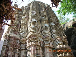
Ratanpur is a town and a nagar palika in Bilaspur district in the Indian state of Chhattisgarh. It is located about 25 kilometres (16 mi) from Bilaspur on National Highway 130 towards Ambikapur.

<span class="mw-page-title-main">Mahasamund district</span> District of Chhattisgarh in India

Mahasamund district is a district in Chhattisgarh state in central India. The city of Mahasamund is the district headquarters. The district is particularly famous for the historical temple town of Sirpur besides the Mahanadi river.

<span class="mw-page-title-main">Chhattisgarh Division</span> Administrative division of the Central Provinces of British India

Chhattisgarh Division was an administrative division of the Central Provinces of British India. It was located in the east of the Central Provinces and encompassed the upper Mahanadi River basin, in the central part of present-day Chhattisgarh state of India.

<span class="mw-page-title-main">Haihaiyavanshi Kingdom</span>

The Haihaiyavansi Kingdom, ruled by the Kalachuris of Raipur was a kingdom which consisted of the central part of the present-day state of Chhattisgarh located in India.

<span class="mw-page-title-main">Bhunjia</span> Scheduled tribe in Odisha, India

Bhunjias, are an ethnic group found in India mainly reside in Sunabeda plateau in Odisha and Chhattisgarh. They are mostly found in Nuapada district, which is roughly between 22° 55′ N and 21° 30′ N latitude and 82° 35′ E longitude. It was a part of Khariar Zamindari, which formed the eastern and the southeastern region of Raipur district of Chhattisgarh division in Central Province till 1 April 1936, when it was transferred to Odisha on its creation. It is now in Komna block of Nuapada district in Orissa. In Chhattisgarh they are found in Raipur district.

<span class="mw-page-title-main">Bemetara district</span> District of Chhattisgarh in India

Bemetara district is a new district in the state of Chhattisgarh, India.

<span class="mw-page-title-main">Gariaband district</span> District of Chhattisgarh in India

Gariaband District is one of the 33 districts of Chhattisgarh. It has its headquarters at Gariaband town. The district was carved out of Raipur district in 2012.

<span class="mw-page-title-main">Surajpur district</span> District In Chhattisgarh, India

Surajpur district is a district in the state of Chhattisgarh in central India, with its administrative headquarters at Surajpur. National Highway 43 passes through Surajpur district. Surajpur was declared a district on 15 August 2011 by the state former Chief Minister Dr. Raman Singh along with eight other new districts. Surajpur is the first district to receive National Satyan Maitra Literacy Award. The district is known for its market and other major tourist places of Chhattisgarh with Tamor Pingla Wildlife Sanctuary.

<span class="mw-page-title-main">Baloda Bazar district</span> District of Chhattisgarh in India

Baloda Bazar - Bhatapara is a district in Chhattisgarh state of India with its headquarters at Baloda Bazar. Before its creation, it was a part of Raipur district. The border of Balodabazar-Bhatapara district touches Bemetara, Mungeli, Bilaspur, Janjgir, Raigarh, Mahasamund and Raipur districts. According to the prevalent tradition in relation to the naming of the Balodabazar in the past, the traders of Gujarat, Haryana, Maharashtra, Orissa, Barar etc. used to gather in the market buffaloes of the city to sell the buffalo, buffalo (Boda). As a result, its name became popular in the name of the bullboda market and in the form of the Baloda Bazar.

<span class="mw-page-title-main">Kalachuris of Ratnapura</span> Central Indian dynasty

The Kalachuris of Ratnapura were a central Indian dynasty during 11th and 12th centuries. They ruled parts of present-day Chhattisgarh from their capital at Ratnapura. They were an offshoot of the Kalachuris of Tripuri, and ruled as vassals of the parent dynasty for many years.

<span class="mw-page-title-main">Gaurela-Pendra-Marwahi district</span> District of Chhattisgarh in India

Gaurela-Pendra-Marwahi district is a district in the Indian state of Chhattisgarh. Gaurella is the headquarters of the district. It was carved out of Bilaspur district and inaugurated in February 2020.

The siege of Ratanpur in 1740 was a siege laid by the Marathas of Nagpur on the fort of Ratanpur, capital of the Haihaiyavanshi Kingdom. There was almost no resistance by the Haihaiyavanshis, which resulted in a Maratha victory.

Mohan Singh was the last ruler of the Haihaiyavanshi Kingdom, the dynasty which ruled Chhattisgarh for over 700 years. He ruled Chhattisgarh under the suzerainty of the Bhonsles of Nagpur Kingdom.

<span class="mw-page-title-main">Mekala</span> Geographical region in India, Asia

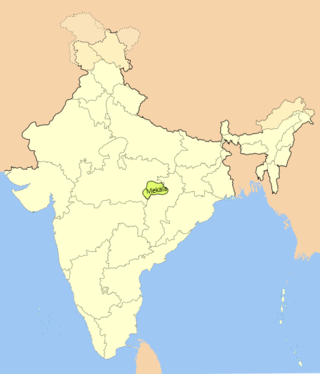
Mekala is a historical region of India, extending from Amarkantak to Balaghat. It corresponds to the Maikal Hills, which comprises the present-day Kawardha District of Chhattisgarh state and Anuppur district of Madhya Pradesh. In the medieval period, the region was ruled by the Panduvamshis of Mekala.

Babu Revaram was a prominent poet and historian of Chhattisgarh, who played a vital role in reconstructing the history of that region. He is known as the "first historian of Chhattisgarh" because he wrote several important historical works such as the Tawarikh Shri Haihaiyavamsa Rajaon ki and Ratanpur Itihas. He also wrote poetic works like Saar Ramayana Deepika and Geeta Madhav. The term "Chhattisgarh" was first used in a historical text by Babu Revaram in his Vikram Vilas, published in 1839.

References

  1. 1 2 "Central Provinces District Gazetteers: Raipur District, Volume A descriptive". INDIAN CULTURE. Retrieved 2021-07-04.
  2. "District Census Handbook: Raipur" (PDF). censusindia.gov.in. Registrar General and Census Commissioner of India. 2011.
  3. "Table C-01 Population by Religion: Chhattisgarh". censusindia.gov.in. Registrar General and Census Commissioner of India. 2011.
  4. 1 2 "Table C-16 Population by Mother Tongue: Chhattisgarh". www.censusindia.gov.in. Registrar General and Census Commissioner of India.
  5. M. Paul Lewis, ed. (2009). "Bhunjia: A language of India". Ethnologue: Languages of the World (16th ed.). Dallas, Texas: SIL International. Retrieved 2011-09-30.