Reading, Vermont

Last updated

Reading, Vermont
Bennett House Reading.jpg
Bennett's 1815 House, located at the junction of Vermont Routes 44 and 106, southeast of the town center
Windsor County Vermont incorporated and unincorporated areas Reading highlighted.svg
Location in Windsor County and the state of Vermont.
Usa edcp location map.svg
Red pog.svg
Reading, Vermont
Location in the United States
Coordinates: 43°29′39″N72°35′47″W / 43.49417°N 72.59639°W / 43.49417; -72.59639
Country United States
State Vermont
County Windsor
Area
  Total41.7 sq mi (107.9 km2)
  Land41.5 sq mi (107.5 km2)
  Water0.2 sq mi (0.4 km2)
Elevation
1,870 ft (570 m)
Population
 (2020)
  Total687
  Density16/sq mi (6.4/km2)
Time zone UTC-5 (Eastern (EST))
  Summer (DST) UTC-4 (EDT)
ZIP code
05062
Area code 802
FIPS code 50-58375 [1]
GNIS feature ID1462183 [2]
Website readingvt.govoffice.com

Reading is a town in Windsor County, Vermont, United States. The population was 687 at the 2020 census. [3]

Contents

History

On August 30, 1754, after being captured by Abenakis at Fort at Number 4, Charlestown, New Hampshire, and being force-marched to Montreal, Susannah Willard Johnson gave birth to a daughter about .5 miles (0.80 km) up Knapp Brook. A marker beside Vermont Route 106 commemorates this event. [4]

Geography

According to the United States Census Bureau, the town has a total area of 41.7 square miles (107.9 km2), of which 41.5 square miles (107.5 km2) is land and 0.2 square mile (0.4 km2) (0.41%) is water.

Landmarks

Reading is the home of Jenne Farm, a tourist attraction that draws in many photographers and other visitors, especially in the autumn.

Demographics

Historical population
CensusPop.Note
1790 747
1800 1,12049.9%
1810 1,56539.7%
1820 1,6032.4%
1830 1,409−12.1%
1840 1,363−3.3%
1850 1,171−14.1%
1860 1,159−1.0%
1870 1,012−12.7%
1880 953−5.8%
1890 749−21.4%
1900 649−13.4%
1910 530−18.3%
1920 463−12.6%
1930 4742.4%
1940 437−7.8%
1950 4707.6%
1960 4720.4%
1970 56419.5%
1980 64714.7%
1990 614−5.1%
2000 70715.1%
2010 666−5.8%
2020 6873.2%
U.S. Decennial Census [5]

As of the census [1] of 2010, there were 666 people, 290 households, and 192 families residing in the town. The population density was 16.0 inhabitants per square mile (6.2/km2). There were 448 housing units at an average density of 10.7 per square mile (4.1/km2). The racial makeup of the town was 99.1% White, 0.0% African American, 0.3% Asian, and 0.6% from two or more races. Hispanic or Latino of any race were 0.6% of the population.

There were 290 households, out of which 24.8% had children under the age of 18 living with them, 54.1% were married couples living together, 9.3% had a female householder with no husband present, 2.8% had a male householder with no wife present, and 33.8% were non-families. 25.50% of all households were made up of individuals, and 11.3% had someone living alone who was 65 years of age or older. The average household size was 2.30 and the average family size was 2.70.

In the town, the population was spread out, with 20.8% age 19 or under, 3.8% from 20 to 24, 20.0% from 25 to 44, 36.1% from 45 to 64, and 19.7% who were 65 years of age or older. The median age was 47.9 years. For every 100 females, there were 94.7 males. For every 100 females age 18 and over, there were 97.4 males.

The median income for a household in the town was $58,667, and the median income for a family was $67,250. Males had a median income of $38,750 versus $29,219 for females. The per capita income for the town was $28,950. About 1.05% of families and 8.8% of the population were below the poverty line, including 12.1% of those under age 18 and 3.7% of those age 65 or over.

Education and Municipal services

Reading Elementary School ReadingElementary School.jpg
Reading Elementary School

Reading is served by Reading Elementary School for Grades Pre-K–6. In 2017–2018, there were a total of 60 students. [6] Student attend grades 7–12 at Woodstock Union High and Middle School. This school is part of the Windsor Central Unified District as of July 1, 2018, as part of Vermont Act 46 changes.

Notable people

Related Research Articles

<span class="mw-page-title-main">Windsor County, Vermont</span> County in Vermont, United States

Windsor County is a county located in the U.S. state of Vermont. As of the 2020 census, the population was 57,753. The shire town is the town of Woodstock. The county's largest municipality is the town of Hartford.

<span class="mw-page-title-main">Orange County, Vermont</span> County in Vermont, United States

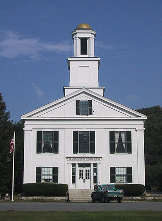
Orange County is a county located in the U.S. state of Vermont. As of the 2020 census, the population was 29,277. Its shire town is the town of Chelsea. Orange County was organized on February 2, 1781, as an original county within the state.

<span class="mw-page-title-main">Landgrove, Vermont</span> Town in Vermont, United States

Landgrove is a town in Bennington County, Vermont, United States. The population was 177 at the 2020 census.

<span class="mw-page-title-main">Enosburgh, Vermont</span> Town in Vermont, United States

Enosburgh is a town in Franklin County, Vermont, in the United States. The population was 2,810 at the 2020 census. Enosburgh includes the village of Enosburg Falls and the settlements of Bordoville, East Enosburgh, North Enosburgh, Sampsonville, West Enosburgh, and Enosburgh Center. Enosburgh was named for Roger Enos, who had been a commander of all the Vermont Forces in the American Revolution. He was also the father-in-law of Ira Allen, founder of Vermont. The spelling of Enosburgh differs from the spelling of Enosburg Falls.

<span class="mw-page-title-main">Vershire, Vermont</span> Town in Vermont, United States

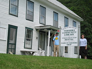
Vershire is a town in Orange County, Vermont, United States, created under Vermont Charter of August 3, 1781. The population was 672 at the 2020 census. The name Vershire is a portmanteau of Vermont and New Hampshire.

<span class="mw-page-title-main">Baltimore, Vermont</span> Town in Vermont, United States

Baltimore is a town in Windsor County, Vermont, United States. The population was 229 at the 2020 census.

<span class="mw-page-title-main">Bethel, Vermont</span> Town in Vermont, United States

Bethel is a town in Windsor County, Vermont, United States. The population was 1,942 at the 2020 census. The town includes the locations of Bethel village, Bethel-Gilead, East Bethel, Lilliesville, Lympus, and West Bethel. Bethel is best known for being the source of Bethel White granite which was used to build Union Station and the National Museum of Natural History. Bethel was the first town created by the independent Republic of Vermont in 1779 and was named after the Biblical village of Bethel.

<span class="mw-page-title-main">Bridgewater, Vermont</span> Town in Vermont, United States

Bridgewater is a town in Windsor County, Vermont, United States. The population was 903 at the 2020 census. Bridgewater contains the hamlets of Bridgewater Village, Bridgewater Corners, West Bridgewater, and Bridgewater Center.

<span class="mw-page-title-main">Cavendish, Vermont</span> Town in Vermont, United States

Cavendish is a town in Windsor County, Vermont, United States. The town was likely named after William Cavendish, 4th Duke of Devonshire. The population was 1,392 at the 2020 census. The town of Cavendish includes the unincorporated villages of Cavendish and Proctorsville.

<span class="mw-page-title-main">Hartford, Vermont</span> Town in Vermont, United States

Hartford is a town in Windsor County, Vermont, United States. It is on the New Hampshire border, at the intersection of Interstates 89 and 91. It is the site of the confluence of the White and Connecticut rivers; the Ottauquechee River also flows through the town. The town is composed of five unincorporated villages: Hartford, Quechee, West Hartford, White River Junction and Wilder. As of the 2020 census, the population was 10,686.

<span class="mw-page-title-main">Hartland, Vermont</span> Town in Vermont, United States

Hartland is a town in Windsor County, Vermont, United States. The population was 3,446 at the 2020 census. It includes the villages of Hartland, Hartland Four Corners, and North Hartland.

<span class="mw-page-title-main">Plymouth, Vermont</span> Town in Vermont, United States

Plymouth is a town in Windsor County, Vermont, United States. The population was 641 at the 2020 census. Calvin Coolidge, the 30th President of the United States, was born and raised in Plymouth and is buried there as well. The State of Vermont Division for Historic Preservation owns and maintains the Coolidge Homestead and the village of Plymouth Notch.

<span class="mw-page-title-main">Rochester, Vermont</span> Town in Vermont

Rochester is a town in Windsor County, Vermont, United States. The population was 1,099 at the 2020 census. The central village is delineated as the Rochester census-designated place.

<span class="mw-page-title-main">Sharon, Vermont</span> Town in Vermont, United States

Sharon is a town in Windsor County, Vermont, United States. It had a population of 1,560 at the 2020 census.

<span class="mw-page-title-main">Stockbridge, Vermont</span> Town in Vermont, United States

Stockbridge is a town in Windsor County, Vermont, United States, which contains the village of Gaysville. The population was 718 at the 2020 census. Stockbridge was one of thirteen Vermont towns isolated by flooding caused by Hurricane Irene in 2011.

<span class="mw-page-title-main">West Windsor, Vermont</span> Town in Vermont, United States

West Windsor is a town in Windsor County, Vermont, United States. The population was 1,344 at the 2020 census. It was known for its Ascutney Mountain Resort, which closed in 2010 and was bought by its citizens in 2015.

<span class="mw-page-title-main">Weston, Vermont</span> Town in Vermont, United States

Weston is a town in Windsor County, Vermont, United States. The population was 623 at the 2020 census. Home to the Weston Playhouse Theatre Company, it includes the villages of Weston and The Island.

<span class="mw-page-title-main">Ludlow (town), Vermont</span> Town in Vermont, United States

Ludlow is a town in Windsor County, Vermont, United States. The population was 2,172 at the 2020 census. Ludlow is the home of Okemo Mountain, a popular ski resort. Before becoming a ski destination, Ludlow was originally a mill town, and was the home of a General Electric plant until 1977. It was named after Ludlow, Massachusetts which is less than 100 miles away. There is also a village of Ludlow in the town.

<span class="mw-page-title-main">Springfield (CDP), Vermont</span> Census-designated place in Vermont, United States

Springfield is a census-designated place (CDP) comprising the main settlement within the town of Springfield, Windsor County, Vermont, United States. The population of the CDP was 3,979 at the 2010 census, compared with 9,373 for the town as a whole.

<span class="mw-page-title-main">Windsor, Wisconsin</span> Village in Wisconsin, United States

Windsor is a village and former town in Dane County, Wisconsin. The population was 8,754 at the time of the 2020 census. The communities of Lake Windsor, Morrisonville, and Token Creek are located within the village. Windsor voted to incorporate as a village on November 3, 2015; prior to its incorporation, it was a town, and a portion of the town was a census-designated place. Windsor is a part of the Census Bureau's Madison metropolitan statistical area.

References

  1. 1 2 "U.S. Census website". United States Census Bureau . Retrieved January 31, 2008.
  2. "US Board on Geographic Names". United States Geological Survey. October 25, 2007. Retrieved January 31, 2008.
  3. "Census - Geography Profile: Reading town, Windsor County, Vermont". United States Census Bureau . Retrieved January 4, 2022.
  4. "VERMONT'S HISTORIC ROADSIDE MARKERS". Vermont State Historic Sites. historicvermont.org. August 26, 2010. Archived from the original on February 3, 2006.
  5. "U.S. Decennial Census". United States Census Bureau. Retrieved May 16, 2015.
  6. AOE - http://education.vermont.gov/data-and-reporting/school-reports/
  7. "BROWN, Titus, (1786 - 1849)". Biographical Directory of the United States Congress. Retrieved December 10, 2013.

Commons-logo.svg Media related to Reading, Vermont at Wikimedia Commons