
The Massachusetts Bay Transportation Authority is the public agency responsible for operating most public transportation services in Greater Boston, Massachusetts. The MBTA transit network includes the MBTA subway with three metro lines, two light rail lines, and a five-line bus rapid transit system ; MBTA bus local and express service; the twelve-line MBTA Commuter Rail system, and several ferry routes. In 2023, the system had a ridership of 239,981,700, or about 755,500 per weekday as of the fourth quarter of 2023, of which the rapid transit lines averaged 267,100 and the light rail lines 80,300, making it the fourth-busiest rapid transit system and the third-busiest light rail system in the United States. As of the fourth quarter of 2023, average weekday ridership of the commuter rail system was 97,100, making it the fifth-busiest commuter rail system in the U.S.
Transportation in Boston includes roadway, subway, regional rail, air, and sea options for passenger and freight transit in Boston, Massachusetts. The Massachusetts Port Authority (Massport) operates the Port of Boston, which includes a container shipping facility in South Boston, and Logan International Airport, in East Boston. The Massachusetts Bay Transportation Authority (MBTA) operates bus, subway, short-distance rail, and water ferry passenger services throughout the city and region. Amtrak operates passenger rail service to and from major Northeastern cities, and a major bus terminal at South Station is served by varied intercity bus companies. The city is bisected by major highways I-90 and I-93, the intersection of which has undergone a major renovation, nicknamed the Big Dig.
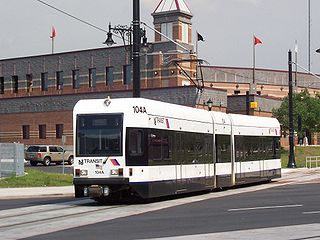
The Newark Light Rail (NLR) is a light rail system serving Newark, New Jersey, and surrounding areas, owned by New Jersey Transit and operated by its bus operations division. The service consists of two segments, the original Newark City Subway (NCS), and the extension to Broad Street station. The City Subway opened on May 16, 1935, while the combined Newark Light Rail service was officially inaugurated on July 17, 2006.

The Cincinnati Subway was a partially completed rapid transit system beneath the streets of Cincinnati, Ohio. Although the system only grew to a little over 2 miles (3.2 km) in length, its derelict tunnels and stations make up the largest abandoned subway tunnel system in the United States. Construction began in the early 1900s as an upgrade to the Cincinnati streetcar system, but was abandoned due to escalating costs, the collapse of funding amidst political bickering, and the Great Depression during the 1920s and 1930s.

Newark Liberty International Airport Station is a railroad hub on the Northeast Corridor (NEC) in Newark, New Jersey. The station provides access to Newark Liberty International Airport (EWR) via the AirTrain Newark monorail which connects the station to the airport's terminals and parking areas. The station is served by New Jersey Transit's (NJT) Northeast Corridor Line and North Jersey Coast Line and Amtrak's Northeast Regional and Keystone Service trains.

Intermodal passenger transport, also called mixed-mode commuting, involves using two or more modes of transportation in a journey. Mixed-mode commuting is often used to combine the strengths of various transportation options. A major goal of modern intermodal passenger transport is to reduce dependence on the automobile as the major mode of ground transportation and increase use of public transport. To assist the traveller, various intermodal journey planners such as Rome2rio and Google Transit have been devised to help travellers plan and schedule their journey.

The transportation system of New York City is a network of complex infrastructural systems. New York City, being the most populous city in the United States, has a transportation system which includes one of the largest and busiest subway systems in the world; the world's first mechanically ventilated vehicular tunnel; and an aerial tramway. New York City is home to an extensive bus system in each of the five boroughs; citywide and Staten Island ferry systems; and numerous yellow taxis and boro taxis throughout the city. Private cars are less used compared to other cities in the rest of the United States.

Springfield Union Station is a train and bus station in the Metro Center area of Springfield, Massachusetts. Constructed in 1926, Springfield Union Station is the fifth-busiest Amtrak station in the Commonwealth, and the busiest outside of Greater Boston.

Quincy Center station is an intermodal transit station in Quincy, Massachusetts. It is a transfer station between the MBTA Red Line subway, MBTA Commuter Rail's Old Colony Lines and Greenbush Line, and a number of MBTA bus routes. It is located between Hancock Street and Burgin Parkway in the Quincy Center district. Opened in 1971, the station was covered by a large parking garage which was closed in 2012 due to structural problems and removed several years later. The station is accessible on all modes.
The Southwest Ohio Regional Transit Authority (SORTA) is the public transport agency serving Cincinnati and its Ohio suburbs. SORTA operates Metro fixed-route buses, bus rapid transit, microtransit, and paratransit services. SORTA's headquarters are located at the Huntington Building in Cincinnati’s Central Business District. The agency is managed by CEO and General Manager Darryl Haley along with a 13-member board of trustees. In 2023, the system had a ridership of 13,091,500, or about 44,800 per weekday as of the fourth quarter of 2023.

RTD Bus and Rail is a transit system in the Denver, Colorado, metropolitan area. Operated by the Regional Transportation District (RTD), it currently runs 86 local, 23 regional, 14 limited, and 3 skyRide bus routes plus some special services. It also includes 6 light rail lines and an additional 4 commuter rail lines with 77 stations and 113.1 miles (182.0 km) of track.
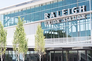
Raleigh Union Station is an intermodal transit station in Raleigh, North Carolina, United States. Train service began the morning of July 10, 2018. Its main building serves as an Amtrak train station, while a future adjacent building will serve as the bus terminus for GoTriangle. The station is located at the Boylan Wye, a railroad junction used by CSX and Norfolk Southern, and adjacent to the Depot Historic District in downtown Raleigh.

MetroMoves was a 2002 proposal by the Southwest Ohio Regional Transit Authority (SORTA) to expand and improve public transportation in the greater Cincinnati metropolitan area. The 30-year vision included the addition of light rail lines, commuter rail lines, streetcars in the downtown area, and expanded bus routes. When put to a vote the citizens of Hamilton County rejected the proposal by nearly a 2-to-1 ratio, 68.4% to 31.6%.

The Connector is a streetcar system in Cincinnati, Ohio, United States. The system opened to passengers on September 9, 2016. The streetcar operates on a 3.6-mile (5.8 km) loop from The Banks, Great American Ball Park, Paycor Stadium, and Smale Riverfront Park through Downtown Cincinnati and north to Findlay Market in the northern edge of the Over-the-Rhine neighborhood. Future extensions have been proposed to the Uptown area, home to the University of Cincinnati, the regional hospitals on Pill Hill, and the Cincinnati Zoo; and to Northern Kentucky.
Public transport is a system of transport for passengers by group travel systems available for use by the general public unlike private transport, typically managed on a schedule, operated on established routes, and that may charge a posted fee for each trip. There is no rigid definition of which kinds of transport are included, and air travel is often not thought of when discussing public transport—dictionaries use wording like "buses, trains, etc." Examples of public transport include city buses, trolleybuses, trams and passenger trains, rapid transit and ferries. Public transport between cities is dominated by airlines, coaches, and intercity rail. High-speed rail networks are being developed in many parts of the world.
Based in southwest Ohio, the Eastern Corridor Program is a regional effort that integrates roadway network improvements, new rail transit, expanded bus service, bikeways and walking paths to improve travel and access between Greater Cincinnati's eastern communities and its central employment, economic and social centers. The Program is designed to address the long-standing transportation needs of the region and to provide additional opportunity for community enhancement, economic development and regional growth.
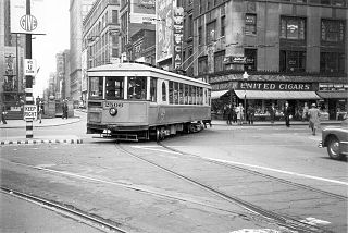
Streetcars operated by the Cincinnati Street Railway were the main form of public transportation in Cincinnati, Ohio, at the end of the 19th century and the start of the 20th century. The first electric streetcars began operation in 1889, and at its maximum, the streetcar system had 222 miles (357 km) of track and carried more than 100 million passengers per year. A very unusual feature of the system was that cars on some of its routes traveled via inclined railways to serve areas on hills near downtown. With the advent of inexpensive automobiles and improved roads, transit ridership declined in the 20th century and the streetcar system closed in 1951. Construction of a new streetcar system, now known as the Connector, began in 2012. Consisting initially of a single route, the new system opened on September 9, 2016.
Transportation in Cincinnati includes sidewalks, roads, public transit, bicycle paths, and regional and international airports. Most trips are made by car, with transit and bicycles having a relatively low share of total trips; in a region of just over 2 million people, less than 80,000 trips are made with transit on an average day. The city is sliced by three major interstate highways, I-71, I-74 and I-75, and circled by a beltway several miles out from the city limits. The region is served by two separate transit systems, one on each side of the river. SORTA, on the Ohio side is about six times larger than TANK on the Kentucky side.
The Oasis Subdivision is a rail line in and near eastern Cincinnati. It is owned by the Southwest Ohio Regional Transit Authority (SORTA) and operated by the Indiana and Ohio Railway for freight traffic.

Butler County Regional Transit Authority, also stylized as BCRTA, is the primary provider of mass transportation in Butler County, Ohio with twelve routes serving the region. As of 2019, the system provided 620,233 rides over 70,789 annual vehicle revenue hours with 18 buses and 17 paratransit vehicles.


