Mount Auburn Historic District

Last updated
Mount Auburn Historic District
Cincinnati part IX embracing 11th & 19th wards. (1869).png
A map of Mount Auburn circa 1869. Visible are the house of Alphonso Taft (which is now the William Howard Taft National Historic Site), the Cincinnati Orphan Asylum and the Mount Auburn Young Ladies Institute.
USA Ohio location map.svg
Red pog.svg
Usa edcp location map.svg
Red pog.svg
LocationBoth sides of Auburn Ave. from Ringgold St. to Howard Taft Rd., Cincinnati, Ohio
Coordinates 39°7′12″N84°30′30″W / 39.12000°N 84.50833°W / 39.12000; -84.50833 Coordinates: 39°7′12″N84°30′30″W / 39.12000°N 84.50833°W / 39.12000; -84.50833
Area414 acres (1.68 km2), 31 buildings
Built1819
Architectural styleMid 19th Century Revival, Late Victorian
NRHP reference No. 73001464 [1]
Added to NRHPMarch 28, 1973

Mount Auburn Historic District is located in the Mount Auburn neighborhood of Cincinnati, Ohio. It extends along both sides of Auburn Avenue roughly between Ringold Street and William H. Taft Road. The population of Mount Auburn was 5,094 at the 2020 census.

Contents

The District was placed on the National Register of Historic Places on March 28, 1973 (No. 73001464). Mount Auburn was founded as a hilltop retreat for Cincinnati's social elite where wealthier people could escape the dirt, heat, smoke and crowded conditions of the lower city. Ornate historic mansions with incredible panoramic views still reflect this heritage.

The district contains notable houses of Federal, Greek Revival, Italian Villa, Romanesque Revival, and Georgian Revival styles. The houses date from 1819 to the turn of the century and are associated with the prominent Cincinnatians. Noted residents include President William Howard Taft.

Demographics

Population of Mt. Auburn 1900-2020
YearPop.±%
1900 11,625    
1910 13,168+13.3%
1920 15,100+14.7%
1930 15,512+2.7%
1940 14,264−8.0%
1950 16,769+17.6%
1960 16,821+0.3%
1970 12,549−25.4%
1980 8,889−29.2%
1990 7,452−16.2%
2000 6,516−12.6%
2010 4,904−24.7%
2020 5,070+3.4%

Source - City of Cincinnati Statistical Database

History

Mt. Auburn was for a long time almost the only suburb of the city. It was at first called Keys' Hill, [2] after an old settler, and this name was used until 1837. By 1826 a number of prominent citizens had taken up residence there. [3]

Mount Auburn was platted as a town in 1837. It owes its name to the then newly established Mount Auburn Cemetery of Boston. [4] By 1842, it extended from Liberty Street (Liberty Street got its name because the city laws were not enforced north of it and it was the location of the "northern liberties" – gambling, drinking and carousing) to McMillan Street (note that the historic district only goes as far south as Ringold Street, the rest of the Mount Auburn neighborhood to the south is the Prospect Hill Historic District). [2] Mount Auburn was annexed to the City of Cincinnati in 1849. [5]

Television

Mount Auburn is the main major television broadcast facility location for the Cincinnati area.

Stations that transmit from Mount Auburn:

WLWT has their studios on Young Street, and their transmitter on Chickasaw Street

WKRC-TV has studios and Transmitter located on Highland Avenue.

WCPO-TV has their transmitter on Symes Street, the tower also holds WBQC-LD.

WCET (TV) has their transmitter located on Chickasaw Street with WLWT.

Buildings and sites

Other notable architecture

Schools

Medical institutions

Commentary

I was quite charmed with the appearance of the town, and its adjoining suburb of Mount Auburn: from which the city, lying in an amphitheatre of hills, forms a picture of remarkable beauty, and is seen to great advantage.

Behold the Fifth Avenue of Cincinnati! It is not merely the pleasant street of villas and gardens along the brow of the hill, though that is part of it. Mount to the cupola of the Mount Auburn Young Ladies' School, which stands near the highest point, and look out over a sea of beautifully formed, umbrageous hills, steep enough to be picturesque, but not too steep to be convenient, and observe that upon each summit, as far as the eye can reach, is an elegant cottage or mansion, or clust of tasteful villas, surrounded by groves, gardens and lawns. This is Cincinnati's Fifth Avenue.

James Parton, Atlantic Monthly , August, 1867

Related Research Articles

<span class="mw-page-title-main">Mount Auburn Cemetery</span> Historic cemetery in Middlesex County, Massachusetts

Mount Auburn Cemetery is the first rural, or garden, cemetery in the United States, located on the line between Cambridge and Watertown in Middlesex County, Massachusetts, 4 miles (6.4 km) west of Boston. It is the burial site of many prominent Boston Brahmins, as well as being a National Historic Landmark.

<span class="mw-page-title-main">WLWT</span> NBC affiliate in Cincinnati

WLWT is a television station in Cincinnati, Ohio, United States, affiliated with NBC and owned by Hearst Television. The station's studios are located on Young Street, and its transmitter is located on Chickasaw Street, both in the Mount Auburn neighborhood of Cincinnati.

<span class="mw-page-title-main">Mount Washington, Cincinnati</span> Neighborhood in Hamilton, Ohio, United States

Mount Washington is a community on the east side of Cincinnati, Ohio, United States. As one of Cincinnati's 52 neighborhoods, Mount Washington lies within the city corporation limits, and borders the neighborhoods of California and the East End, as well as unincorporated Anderson Township, Hamilton County, Ohio. It is served by the 24, 30, and 81 Metro bus routes.

<span class="mw-page-title-main">William Howard Taft National Historic Site</span> National Historic Site of the United States

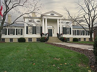
William Howard Taft National Historic Site is a historic house at 2038 Auburn Avenue in the Mount Auburn Historic District of Cincinnati, Ohio, a mile (1.6 km) north of Downtown. It was the birthplace and childhood home of William Howard Taft, the 27th president and the 10th chief justice of the United States. It is a two-story Greek Revival house built circa 1845.

<span class="mw-page-title-main">Taft Museum of Art</span> Historic house in Ohio, United States

The Taft Museum of Art is a fine art collection in Cincinnati, Ohio. It occupies the 200-year-old historic house at 316 Pike Street. The house – the oldest domestic wooden structure in downtown Cincinnati – was built about 1820 and housed several prominent Cincinnatians, including Martin Baum, Nicholas Longworth, David Sinton, Anna Sinton Taft and Charles Phelps Taft. It is on the National Register of Historic Places listings, and is a contributing property to the Lytle Park Historic District.

<span class="mw-page-title-main">Spring Grove Cemetery</span> United States historic place

Spring Grove Cemetery and Arboretum is a nonprofit rural cemetery and arboretum located at 4521 Spring Grove Avenue, Cincinnati, Ohio. It is the third largest cemetery in the United States, after the Calverton National Cemetery and Abraham Lincoln National Cemetery and is recognized as a US National Historic Landmark.

<span class="mw-page-title-main">Mount Lookout, Cincinnati</span> Neighborhood of Cincinnati, Ohio, United States

Mount Lookout, Ohio is one of the Eastern neighborhoods of Cincinnati, just northwest of Linwood and overlooking the Ohio River valley.

This is relating to the culture of Cincinnati, Ohio.

<span class="mw-page-title-main">East Walnut Hills, Cincinnati</span> Place in Ohio, United States

East Walnut Hills is a neighborhood on the Southeast side of Cincinnati, Ohio. The population was 4,103 at the 2020 census.

<span class="mw-page-title-main">Prospect Hill, Cincinnati</span> United States historic place

Prospect Hill Historic District is located on a hillside outside of downtown Cincinnati, Ohio, United States. It is part of the Mount Auburn neighborhood of Cincinnati. Prospect Hill is bounded by the following streets, Liberty, Sycamore, Boal and Highland. Prospect Hill is sometimes called locally "Liberty Hill".

<span class="mw-page-title-main">The Alexandra (Cincinnati, Ohio)</span> United States historic place

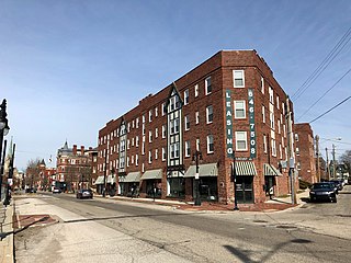
The Alexandra is a historic apartment building located on Gilbert Avenue in the Walnut Hills neighborhood of Cincinnati, Ohio, United States. Constructed in 1904 as the neighborhood's first large apartment building, it was one of many such buildings constructed for the real estate management firm of Thomas J. Emery's Sons. It has been named a historic site.

<span class="mw-page-title-main">Gorham A. Worth House</span> Historic house in Ohio, United States

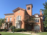
The Gorham A. Worth House is a historic residence in the Mount Auburn neighborhood of Cincinnati, Ohio, United States. Located atop a hill along Auburncrest Avenue, the house was built in 1819 in a version of the Federal style of architecture.

<span class="mw-page-title-main">William Howard Doane</span> American businessman and composer (1832–1915)

William Howard Doane was a manufacturer, inventor, hymn writer, choral director, church leader and philanthropist. He composed over 2,000 church hymns. More than seventy patents are credited to him for innovations in woodworking machinery. His philanthropy led to the renaming of the Granville Academy, as the Doane Academy, a boys' and girls' private preparatory school associated with Denison University in Granville, Ohio, where he was a major benefactor.

<span class="mw-page-title-main">Brattle Street (Cambridge, Massachusetts)</span>

Brattle Street in Cambridge, Massachusetts, called the "King's Highway" or "Tory Row" before the American Revolutionary War, is the site of many buildings of historic interest, including the modernist glass-and-concrete building that housed the Design Research store, and a Georgian mansion where George Washington and Henry Wadsworth Longfellow both lived, as well as John Vassall and his seven slaves including Darby Vassall. Samuel Atkins Eliot, writing in 1913 about the seven Colonial mansions of Brattle Street's "Tory Row," called the area "not only one of the most beautiful but also one of the most historic streets in America." "As a fashionable address it is doubtful if any other residential street in this country has enjoyed such long and uninterrupted prestige."

<span class="mw-page-title-main">Lytle Park Historic District</span> Historic district in Ohio, United States

Lytle Park Historic District is a historic district in Cincinnati, Ohio, United States. Roughly bounded by 3rd, 5th, Sycamore, Commercial Sq., and Butler Sts. in downtown Cincinnati, it centers on Lytle Park.

The WLWT TV Tower is a free-standing lattice tower with triangular cross section used by WLWT located in Cincinnati, Ohio. Built in 1978, it replaced the original 570-foot tall WLWT tower built in 1948 at the same site on Chickasaw Street, in the Mount Auburn neighborhood of Cincinnati. The new tower stands 289.6 m (950 ft) tall, one of four that rise above 900 feet in the city and is among the tallest lattice towers in the world.

References

  1. "National Register Information System". National Register of Historic Places . National Park Service. January 23, 2007.
  2. 1 2 Rider, Peg (May 21, 1989). "Mt. Auburn". Prospect Hill, A Neighborhood Reborn (1807–present). Archived from the original on September 30, 2007. Retrieved 2007-06-24.
  3. Clarke, S. J. (1912). Cincinnati, the Queen City, 1788-1912, Volume 2. The S. J. Clarke Publishing Company. p. 531. Retrieved 2013-05-20.
  4. Stradling, David (Oct 1, 2003). Cincinnati: From River City to Highway Metropolis. Arcadia Publishing. p. 37. ISBN   9780738524405 . Retrieved 2013-05-25.
  5. Federal Writers' Project (1943). Cincinnati, a Guide to the Queen City and Its Neighbors. p. 357. ISBN   9781623760519 . Retrieved 2013-05-04.