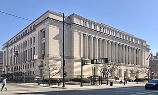
Hamilton County is located in the southwestern corner of the U.S. state of Ohio. As of the 2020 census, the population was 830,639, making it the third-most populous county in Ohio. The county seat and largest city is Cincinnati. The county is named for the first Secretary of the Treasury, Alexander Hamilton. Hamilton County is part of the Cincinnati-Middletown, OH-KY-IN Metropolitan Statistical Area.
Druid Hills is a community which includes both a census-designated place (CDP) in unincorporated DeKalb County, Georgia, United States, as well as a neighborhood of the city of Atlanta. The CDP's population was 14,568 at the 2010 census. The CDP formerly contained the main campus of Emory University and the Centers for Disease Control and Prevention (CDC) however they were annexed by Atlanta in 2018. The Atlanta-city section of Druid Hills is one of Atlanta's most affluent neighborhoods with a mean household income in excess of $238,500.

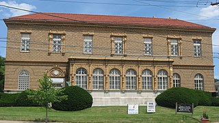
Wyoming is a city in Hamilton County, Ohio; located approximately 12 miles north of downtown Cincinnati and part of the Cincinnati metropolitan area. The population was 8,756 at the 2020 census.
Bond Hill is one of the 52 neighborhoods of Cincinnati, Ohio. Founded as a railroad suburb and temperance community in 1870 in northeastern Millcreek Township, it is one of a number of neighborhoods lining the Mill Creek. The population was 7,002 at the 2020 census.

Evanston is one of the 52 neighborhoods of Cincinnati, Ohio. A mostly African-American neighborhood since the 1960s, it is known as "the educating community," and is bordered by the neighborhoods of East Walnut Hills, Hyde Park, North Avondale, and Walnut Hills, as well as the City of Norwood. The population was 8,838 at the 2020 census.

Clifton is is one of the 52 neighborhoods of Cincinnati, Ohio. The population was 8,408 in the 2020 census.

Northside is one of the 52 neighborhoods of Cincinnati, Ohio. It was originally known as Cumminsville, but renamed to "Northside" several decades ago after I-74 divided the neighborhood into Northside and South Cumminsville. Northside has a racially and socio-economically diverse population, with concentrations of college students, artists, young professionals, and many members of the creative class. It is also the city's gay village, hosting several local LGBT organizations and events. The population was 8,096 at the 2020 census.

Hyde Park is one of the 52 neighborhoods of Cincinnati, Ohio. Originally established as a retreat for the city's wealthy, the neighborhood is predominately residential, with a central business district known as Hyde Park Square. The population was 14,193 at the 2020 census.
East Walnut Hills is one of the 52 neighborhoods of Cincinnati, Ohio. Established in 1867 and annexed in 1873, it is located in the eastern side of the city. The population was 4,103 at the 2020 census.
Westwood is one of the 52 neighborhoods of Cincinnati, Ohio. Annexed in 1896 and located in the western part of the city, it is the city's largest neighborhood in both area and population. The population was 33,774 at the 2020 census.

Camp Washington is a neighborhood of Cincinnati, Ohio, United States. Located next to the Mill Creek, it is north of Queensgate, east of Fairmount, and west of Clifton and University Heights. The community is a crossing of 19th-century homes and industrial space The population was 1,234 at the 2020 census.

Carthage is one of the 52 neighborhoods of Cincinnati, Ohio. Established in 1791 or 1792 and annexed in 1911, it is located in the northern part of the city's Mill Creek valley. The neighborhood is predominately residential, and is center of the city's Hispanic community. It shares a border with Elmwood Place, Ohio, which, with adjacent St. Bernard, Ohio, forms an enclave in the middle of Cincinnati. The population was 2,781 at the 2020 census.

College Hill is one of the 52 neighborhoods of Cincinnati, Ohio. Established in 1813 and annexed in 1911, 1915, and 1923, it is located in the northwestern part of the city. It was originally called Pleasant Hill due to its prime location, but was later renamed College Hill because of the two colleges that were established there in the mid-nineteenth century. The neighborhood is not to be confused with North College Hill, which borders College Hill to the north but is not part of Cincinnati. The population was 16,039 at the 2020 census.

Mount Airy is one of the 52 neighborhoods of Cincinnati, Ohio. The neighborhood is home to Mount Airy Forest, one of the oldest urban reforestation projects in the country. The population was 9,210 at the 2020 census.

Riverside is one of the 52 neighborhoods of Cincinnati, Ohio. The neighborhood is contained in a narrow strip of land along the Ohio River on the city's west side, between Sayler Park and Sedamsville. Predominately industrial, the neighborhood has few residential areas, with a population of 1,257 at the 2020 census.

Sedamsville is one of the 52 neighborhoods of Cincinnati, Ohio. Established in 1795 and annexed in 1870, the neighborhood lies along the Ohio River in the western part of the city. The population was 1,256 at the 2020 census.

South Cumminsville is one of the 52 neighborhoods of Cincinnati, Ohio. The population was 702 at the 2020 census.

South Fairmount is one of the 52 neighborhoods of Cincinnati, Ohio. Located in the western part of the city, it contains one of the highest concentrations of Section 8 housing in Hamilton County. The population was 2,181 at the 2020 census.

Downtown Cincinnati is the central business district of Cincinnati, Ohio, United States, as well the economic and symbiotic center of the Cincinnati metropolitan area. Originally the densely populated core of the city, the neighborhood was transformed into a commercial zone in the mid-20th century. The population was 5,835 at the 2020 census.

Hartwell is one of the 52 neighborhoods of Cincinnati, Ohio. Established in 1868 and annexed in 1912, it is the city's northernmost neighborhood, centered roughly on the intersections of I-75 and Ronald Reagan Cross County Highway. Its boundaries are a combination of Caldwell Park and Ronald Reagan Cross County Highway to the south, I-75 to the east, and a combination of Millsdale Street and Compton Road to the North. The population was 5,806 at the 2020 census.


