Rocheport, Missouri | |
---|---|
City of Rocheport | |
Coordinates: 38°58′42″N92°33′48″W / 38.97833°N 92.56333°W Coordinates: 38°58′42″N92°33′48″W / 38.97833°N 92.56333°W | |
Country | United States |
State | Missouri |
County | Boone |
Area | |
• Total | 0.32 sq mi (0.82 km2) |
• Land | 0.32 sq mi (0.82 km2) |
• Water | 0.00 sq mi (0.00 km2) |
Elevation | 594 ft (181 m) |
Population (2020) | |
• Total | 201 |
• Density | 634.07/sq mi (244.93/km2) |
Time zone | UTC-6 (Central (CST)) |
• Summer (DST) | UTC-5 (CDT) |
ZIP code | 65279 |
Area code | 573 |
FIPS code | 29-62498 [3] |
GNIS feature ID | 2396393 [2] |
Website | https://rocheport.com/ |
Rocheport is a city in Boone County, Missouri, United States. It is part of the Columbia, Missouri Metropolitan Statistical Area. The population was 239 at the 2010 census. Rocheport includes the Rocheport Historic District, an area with buildings dating from 1830 and which is listed on the National Register of Historic Places.
Rocheport was a trading post for both settlers and Native Americans. After the purchase of the Louisiana Territory in 1803, President Thomas Jefferson commissioned Meriwether Lewis and William Clark to lead an expedition to explore the western territories. On June 7, 1804, their journey led them to the convergence of the Missouri River and Moniteau Creek near the future settlement of Rocheport. Clark noted the features of the land, flora, fauna and native pictographs on the bluffs in his journal. The Sauk leader Quashquame led a village of Sauk, Meskwaki, and Ioway near Rocheport, along Moniteau Creek in the first decade of the 19th century; [4] this village was noted by Zebulon Pike in 1806. [5] Rocheport became a permanent settlement in the early nineteenth century. Rocheport is a French name meaning "rocky port". [6]
The Moses U. Payne House is a historic structured located just outside Rocheport.
According to the United States Census Bureau, the city has a total area of 0.27 square miles (0.70 km2), all land. [7]
Census | Pop. | Note | %± |
---|---|---|---|
1860 | 735 | — | |
1870 | 823 | 12.0% | |
1880 | 728 | −11.5% | |
1890 | 631 | −13.3% | |
1900 | 593 | −6.0% | |
1910 | 434 | −26.8% | |
1920 | 458 | 5.5% | |
1930 | 455 | −0.7% | |
1940 | 396 | −13.0% | |
1950 | 376 | −5.1% | |
1960 | 375 | −0.3% | |
1970 | 307 | −18.1% | |
1980 | 272 | −11.4% | |
1990 | 255 | −6.2% | |
2000 | 208 | −18.4% | |
2010 | 239 | 14.9% | |
2020 | 201 | −15.9% | |
U.S. Decennial Census [8] |
As of the census [9] of 2010, there were 239 people, 121 households, and 63 families living in the city. The population density was 885.2 inhabitants per square mile (341.8/km2). There were 128 housing units at an average density of 474.1 per square mile (183.1/km2). The racial makeup of the city was 91.2% White, 3.8% African American, 2.1% Native American, 0.8% Asian, and 2.1% from two or more races. Hispanic or Latino of any race were 0.8% of the population.
There were 121 households, of which 19.0% had children under the age of 18 living with them, 36.4% were married couples living together, 10.7% had a female householder with no husband present, 5.0% had a male householder with no wife present, and 47.9% were non-families. 39.7% of all households were made up of individuals, and 17.4% had someone living alone who was 65 years of age or older. The average household size was 1.97 and the average family size was 2.60.
The median age in the city was 49.3 years. 16.7% of residents were under the age of 18; 4.6% were between the ages of 18 and 24; 23% were from 25 to 44; 34.7% were from 45 to 64; and 20.9% were 65 years of age or older. The gender makeup of the city was 50.2% male and 49.8% female.
As of the census [3] of 2000, there were 208 people, 101 households, and 55 families living in the city. The population density was 774.7 inhabitants per square mile (299.1/km2). There were 122 housing units at an average density of 454.4 per square mile (175.4/km2). The racial makeup of the city was 88.94% White, 3.37% African American, 1.44% Native American, 1.44% Asian, 0.48% from other races, and 4.33% from two or more races.
There were 101 households, out of which 20.8% had children under the age of 18 living with them, 45.5% were married couples living together, 5.9% had a female householder with no husband present, and 44.6% were non-families. 37.6% of all households were made up of individuals, and 17.8% had someone living alone who was 65 years of age or older. The average household size was 2.06 and the average family size was 2.73.
In the city the population was spread out, with 17.8% under the age of 18, 5.3% from 18 to 24, 28.4% from 25 to 44, 27.4% from 45 to 64, and 21.2% who were 65 years of age or older. The median age was 44 years. For every 100 females, there were 80.9 males. For every 100 females age 18 and over, there were 72.7 males.
The median income for a household in the city was $32,188, and the median income for a family was $45,156. Males had a median income of $30,625 versus $20,313 for females. The per capita income for the city was $21,483. About 3.5% of families and 4.9% of the population were below the poverty line, including none of those under the age of eighteen and 7.0% of those 65 or over.
Rocheport offers a variety of shops, art galleries, restaurants and outdoor activities. Rocheport is near the middle of the Katy Trail, a 225-mile-long bike path stretching across the state of Missouri, that was built on a former railroad right-of-way.
Cooper County is located in the central portion of the U.S. state of Missouri. As of the 2020 United States census, the population was 17,103. Its county seat is Boonville. The county was organized December 17, 1818 and named for Sarshell Cooper, a frontier settler who was killed by Native Americans near Arrow Rock in 1814. It is a part of the Columbia, Missouri metropolitan area.
De Witt is a city in Carroll County, Missouri, United States. The population was 83 at the 2020 census.
Mosby is a city in Clay County, Missouri, United States, along the Fishing River. The population was 101 at the 2020 census. It is part of the Kansas City metropolitan area.
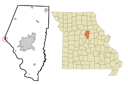
Pilot Grove is a city in the Pilot Grove Township in northern Cooper County, Missouri, United States. The population was 768 at the 2010 census.
Urbana is a city in Dallas County, Missouri, United States. The population was 414 at the 2010 census. It is part of the Springfield, Missouri Metropolitan Statistical Area.
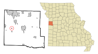
Calhoun is a city in Henry County, Missouri, United States. The population was 469 at the 2010 census.
Linneus is a small city in Linn County, Missouri, United States. The population was 281 at the 2020 census. It is the county seat of Linn County.
Clarksburg is a city in Moniteau County, Missouri, United States. The population was 334 at the 2010 census. It is part of the Jefferson City, Missouri Metropolitan Statistical Area.
Jamestown is a village in northeastern Moniteau County, Missouri, United States. The population was 386 at the 2010 census. It is part of the Jefferson City, Missouri Metropolitan Statistical Area.
Lupus is a city in Moniteau County, Missouri, United States. The population was 33 at the 2010 census. It is part of the Jefferson City, Missouri Metropolitan Statistical Area.
Tipton is a city in Moniteau County, Missouri, United States. The population was 3,262 at the 2010 census. It is part of the Jefferson City, Missouri Metropolitan Statistical Area.
Pickering is a city in Nodaway County, Missouri, United States. The population was 160 at the 2010 census.
Chamois is a city in Osage County, Missouri, United States. The population was 377 at the 2020 census. It is part of the Jefferson City, Missouri Metropolitan Statistical Area.
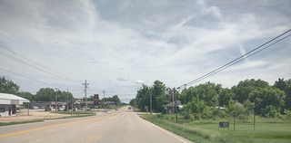
Higbee is a city in southern Randolph County, Missouri, United States. The population was 568 at the 2010 census. Barrel-making company A&K Cooperage, Barrel 53 Cooperage and Woodsmen Distilling are based in Higbee.
Velda City is a city in St. Louis County, Missouri, United States. The population was 1,420 at the 2010 census.
Winchester is a city in St. Louis County, Missouri, United States. The population was 1,447 at the 2020 census.
Merriam Woods is a city in Taney County, Missouri, United States. The population was 2,006 at the 2020 census. It is part of the Branson, Missouri Micropolitan Statistical Area.
Lake Annette is a city in Cass County, Missouri, United States. The population was 100 at the 2010 census. It is part of the Kansas City metropolitan area.
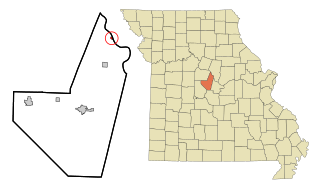
Prairie Home is a town, with legal status as a city, in Cooper County, Missouri, United States. The population was 280 at the 2010 census.
Blackburn is a city in Lafayette and Saline counties in the U.S. state of Missouri and is part of the Kansas City metropolitan area. The population was 249 at the 2010 census.