Related Research Articles
Shaw is an unincorporated community in the Two-Mile Prairie of Boone County, Missouri, United States, northeast of Columbia. It is located at 38°58′25″N92°12′12″W.

Rucker is an unincorporated community in the northwest corner of Boone County, Missouri, United States. The community is located at the intersection of Missouri routes T and F about 6.5 miles north of Harrisburg. The site lies between Perche Creek and Sugar Creek.
Millersburg is an unincorporated community in Callaway County, in the U.S. state of Missouri. It is located near the Boone-Callaway county line on the Owl Creek tributary of Cedar Creek. The Little Dixie Lake and Little Dixie Wildlife Management Area lie on Owl Creek just north of the community. It is on Missouri Route J about four miles south of I-70.
Bourbon is an unincorporated community in northern Boone County, in the U.S. state of Missouri. The community was located on Benson Road just east of U.S. Route 63 and about one mile west of Sturgeon.
Browns is an unincorporated community in Boone County, in the U.S. state of Missouri. It is located northeast of Columbia on Paris Road. Browns was once a stop on the Columbia Terminal Railroad.
Cedar Creek is a stream in Boone and Callaway counties of the U.S. state of Missouri. It is a tributary of the Missouri River. The headwaters of Cedar Creek are in northeast Boone County about five miles east of Hallsville and one mile west of the Audrain-Boone county line. The stream flows south and about five miles south of its headwaters the stream becomes the boundary between Boone and Callaway counties. The stream crosses under Interstate 70 about eight miles east of Columbia and enters the Mark Twain National Forest. The stream flows south to southwest through the national forest and upon leaving the forest turns to the east and ceases to be the county line. The stream flows east for about one mile then turns south and flows under U. S. Route 63 and into the Missouri River four miles northwest of Cedar City and across the river from Jefferson City. The Katy Trail crosses Cedar Creek just north of its confluence with the Missouri.
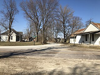
Claysville is an unincorporated community in Boone County, in the U.S. state of Missouri. It is the southernmost settlement in Boone County. Claysville is near the Missouri River.
Deer Park is an unincorporated community in Boone County, in the U.S. state of Missouri. It is located south of Columbia on U.S. Route 63.
Easley is an unincorporated community in Boone County, in the U.S. state of Missouri. The last building remaining in Easley, a general store, was moved to the Boone County Historical Society and reconstructed. Easley is on both the Missouri River and Katy Trail.
Englewood is an unincorporated community in Boone County, in the U.S. state of Missouri.
Ginlet is an unincorporated community in Boone County, in the U.S. state of Missouri.
Harg is an unincorporated community in Boone County, in the U.S. state of Missouri.
Oldham is an unincorporated community in southeast Boone County, in the U.S. state of Missouri. The community is on Old Highway 63 approximately three miles south of Ashland.
Providence is an unincorporated community in Boone County, in the U.S. state of Missouri. Providence was the main port on the Missouri River for supplies to headed to Columbia, Missouri. Providence Road in Columbia is named after the community.
Stephens is an unincorporated community in northwest Callaway County, in the U.S. state of Missouri. The community is one mile east of Cedar Creek and the Callaway-Boone county line. Lindbergh on I-70 lies 1.5 miles to the south.
Youngers is an unincorporated community in northwest Callaway County, in the U.S. state of Missouri. The community is in the extreme northwest corner of Callaway County and just east of Cedar Creek. Auxvasse is about twelve miles to the east, Mexico is about 14 miles to the northeast in Audrain County and Columbia is about nine miles to the southwest in Boone County.
Shannondale is an unincorporated community in Chariton County, in the U.S. state of Missouri.
Spring Garden is an unincorporated community in northeastern Miller County, in the U.S. state of Missouri. The community lies just north of Missouri Route 54, approximately 8.5 miles northeast of Eldon.
Tulip is an unincorporated community in northwest Audrain and southwest Monroe counties, in the U.S. state of Missouri. The community is on Monroe county road 92. Long Branch flows past approximately one mile west and north of the site. Moberly is approximately 15 miles to the north-northwest in Randolph County and Centralia is eight miles south in northeast Boone County, Missouri.
Hanna is a former community in southwestern Pulaski County, in the U.S. state of Missouri.
References
- ↑ U.S. Geological Survey Geographic Names Information System: Wilton, Missouri
- ↑ Missouri Atlas & Gazetteer, DeLorme, 1st edition, 1998, p. 37 ISBN 0899332242
- ↑ "Post Offices". Jim Forte Postal History. Retrieved 4 September 2016.
- ↑ "Boone County Place Names, 1928–1945 (archived)". The State Historical Society of Missouri. Archived from the original on 24 June 2016. Retrieved 4 September 2016.
Municipalities and communities of Boone County, Missouri, United States | ||
|---|---|---|
| Cities |  | |
| Villages | ||
| Townships | ||
| Unincorporated communities | ||
| Ghost towns | ||
| Footnotes | ‡a small part of Centralia is in Audrain County | |
38°44′06″N92°21′33″W / 38.73500°N 92.35917°W
| | This Boone County, Missouri state location article is a stub. You can help Wikipedia by expanding it. |