Rockford, Washington

Last updated

Rockford, Washington
Spokane County Washington Incorporated and Unincorporated areas Rockford Highlighted.svg
Location of Rockford, Washington
Coordinates: 47°27′3″N117°7′58″W / 47.45083°N 117.13278°W / 47.45083; -117.13278
Country United States
State Washington
County Spokane
Area
[1]
  Total0.66 sq mi (1.72 km2)
  Land0.66 sq mi (1.72 km2)
  Water0.00 sq mi (0.00 km2)
Elevation
2,388 ft (728 m)
Population
 (2020)
  Total522
  Density790/sq mi (300/km2)
Time zone UTC-8 (Pacific (PST))
  Summer (DST) UTC-7 (PDT)
ZIP code
99030
Area code 509
FIPS code 53-59145
GNIS feature ID1507868 [2]
Website rockfordwa.com

Rockford is a town in Spokane County, Washington, United States. The population was 522 at the 2020 census. [3]

Contents

History

Rockford was first settled in 1878 by D.C. Farnsworth. [4] The town took its name from a rocky ford on Rock Creek. [5] Rockford was incorporated as a town in 1890. [6]

Geography

Rockford is located at 47°27′3″N117°7′58″W / 47.45083°N 117.13278°W / 47.45083; -117.13278 (47.450891, -117.132870). [7]

According to the United States Census Bureau, the town has a total area of 0.68 square miles (1.76 km2), all of it land. [8]

Demographics

Historical population
CensusPop.Note
1890 644
1900 433−32.8%
1910 66353.1%
1920 435−34.4%
1930 381−12.4%
1940 130−65.9%
1950 15216.9%
1960 369142.8%
1970 327−11.4%
1980 44235.2%
1990 4818.8%
2000 413−14.1%
2010 47013.8%
2020 52211.1%
U.S. Decennial Census [9]

2010 census

As of the 2010 census, [10] there were 470 people, 192 households, and 136 families living in the town. The population density was 691.2 inhabitants per square mile (266.9/km2). There were 213 housing units at an average density of 313.2 per square mile (120.9/km2). The racial makeup of the town was 92.6% White, 0.4% African American, 3.0% Native American, 1.3% Asian, 1.7% from other races, and 1.1% from two or more races. Hispanic or Latino of any race were 3.0% of the population.

There were 192 households, of which 27.1% had children under the age of 18 living with them, 57.3% were married couples living together, 8.3% had a female householder with no husband present, 5.2% had a male householder with no wife present, and 29.2% were non-families. 20.8% of all households were made up of individuals, and 7.3% had someone living alone who was 65 years of age or older. The average household size was 2.45 and the average family size was 2.78.

The median age in the town was 44.9 years. 19.4% of residents were under the age of 18; 6.9% were between the ages of 18 and 24; 24% were from 25 to 44; 33.4% were from 45 to 64; and 16.2% were 65 years of age or older. The gender makeup of the town was 50.2% male and 49.8% female.

2000 census

As of the 2000 census, there were 413 people, 149 households, and 111 families living in the town. The population density was 607.1 people per square mile (234.5/km2). There were 169 housing units at an average density of 248.4 per square mile (96.0/km2). The racial makeup of the town was 97.34% White, 0.24% African American, 0.48% Native American, and 1.94% from two or more races. Hispanic or Latino of any race were 0.48% of the population.

There were 149 households, out of which 40.3% had children under the age of 18 living with them, 59.1% were married couples living together, 9.4% had a female householder with no husband present, and 25.5% were non-families. 20.8% of all households were made up of individuals, and 9.4% had someone living alone who was 65 years of age or older. The average household size was 2.77 and the average family size was 3.17.

In the town, the age distribution of the population shows 29.1% under the age of 18, 7.3% from 18 to 24, 26.9% from 25 to 44, 23.0% from 45 to 64, and 13.8% who were 65 years of age or older. The median age was 38 years. For every 100 females, there were 99.5 males. For every 100 females age 18 and over, there were 98.0 males.

The median income for a household in the town was $40,227, and the median income for a family was $45,125. Males had a median income of $31,339 versus $25,417 for females. The per capita income for the town was $16,411. About 11.9% of families and 12.1% of the population were below the poverty line, including 18.4% of those under age 18 and 3.6% of those age 65 or over.

See also

Related Research Articles

<span class="mw-page-title-main">Rockton, Illinois</span> Village in Illinois, United States

Rockton is a village in Winnebago County, Illinois. It is located in the Rock River Valley and is part of the Rockford metropolitan area. The population was 7,685 at the time of the 2010 census, up from 5,296 at the time of the 2000 census.

<span class="mw-page-title-main">Ulen, Indiana</span> Town in Indiana, United States

Ulen is a town in Center Township, Boone County, in the U.S. state of Indiana. The population was 117 at the 2010 census. The town is surrounded by the city of Lebanon.

<span class="mw-page-title-main">Mount Auburn, Indiana</span> Town in Indiana, United States

Mount Auburn is a town in Jackson Township, Wayne County, in the U.S. state of Indiana. The population was 117 at the 2010 census. The town is sandwiched between Dublin and Cambridge City.

<span class="mw-page-title-main">Marble Rock, Iowa</span> City in Iowa, United States

Marble Rock is a city in Floyd County, Iowa, United States, along the Shell Rock River. The population was 271 at the time of the 2020 census. Marble Rock has a city park, historical museums, a powerhouse on the river, and a veterans' memorial. The Marble Rock Historical Society has a website with information about the museums.

<span class="mw-page-title-main">Rockford, Iowa</span> City in Iowa, United States

Rockford is a city in Floyd County, Iowa, United States, at the confluence of the Shell Rock and Winnebago rivers. The population was 758 at the time of the 2020 census.

<span class="mw-page-title-main">Wade, Maine</span> Town in the state of Maine, United States

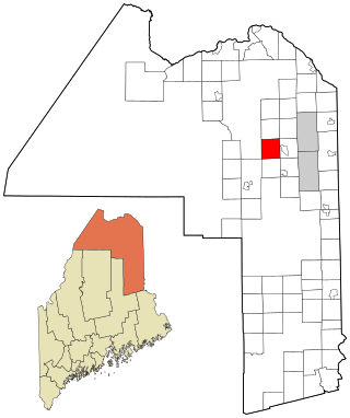
Wade is a town in Aroostook County, Maine, United States. The population was 229 at the 2020 census.

Lowell is a town in Penobscot County, Maine, United States. The population was 368 at the 2020 census.

<span class="mw-page-title-main">Corcoran, Minnesota</span> City in Minnesota, United States

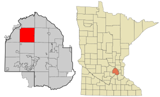
Corcoran is a rural city in Hennepin County, Minnesota, United States. The population was 5,379 at the 2010 census.

<span class="mw-page-title-main">Clarkton, Missouri</span> City in Missouri, United States

Clarkton is a city in Dunklin County, Missouri, United States. The population was 1,288 at the 2010 census. Clarkton is the oldest city in Dunklin County.

<span class="mw-page-title-main">New Rockford, North Dakota</span> City in North Dakota, United States

New Rockford is a city in Eddy County, North Dakota, United States. It is the county seat of Eddy County. The population was 1,361 at the 2020 census. New Rockford was founded in 1883.

<span class="mw-page-title-main">Rockford, Ohio</span> Village in Ohio, United States

Rockford is a village in Mercer County, Ohio, United States. The village is on the St. Mary's River near the center of the western Ohio border 12 miles Northwest of Celina. The population was 1,051 at the 2020 census.

<span class="mw-page-title-main">Fawn Grove, Pennsylvania</span> Borough in Pennsylvania, United States

Fawn Grove is a borough in York County, Pennsylvania, United States. The population was 476 at the 2020 census. It is part of the York–Hanover metropolitan area. It is served by the South Eastern School District, which provides public education.

<span class="mw-page-title-main">Rockford, Tennessee</span> City in Tennessee, United States

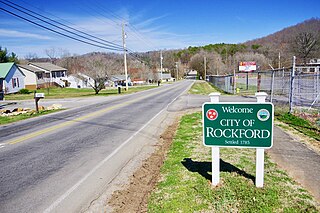
Rockford is a city in Blount County, Tennessee. Its population was 822 at the 2020 census. It is included in the Knoxville, Tennessee Metropolitan Statistical Area.

<span class="mw-page-title-main">Endicott, Washington</span> Town in Washington, United States

Endicott is a town in Whitman County, Washington, United States. The population was 312 at the 2020 census.

<span class="mw-page-title-main">Garfield, Washington</span> Town in Washington, United States

Garfield is a city in Whitman County, Washington, United States. The population was 562 at the 2020 census.

<span class="mw-page-title-main">Oakesdale, Washington</span> Town in Washington, United States

Oakesdale is a town in Whitman County, Washington, United States. The population was 395 at the 2020 census.

<span class="mw-page-title-main">Pax, West Virginia</span> Town in West Virginia, United States

Pax is a town in Fayette County, West Virginia, United States. The current mayor of Pax is William F. Hughes. The population was 167 at the 2010 census.

<span class="mw-page-title-main">Durbin, West Virginia</span> Town in West Virginia, United States

Durbin is a town in Pocahontas County, West Virginia, United States. The population was 235 at the 2020 census.

<span class="mw-page-title-main">Tunnelton, West Virginia</span> Town in West Virginia, United States

Tunnelton is a town in southwestern Preston County, West Virginia, United States. The population was 307 at the 2020 census. It is part of the Morgantown metropolitan area.

<span class="mw-page-title-main">Byron, Fond du Lac County, Wisconsin</span> Town in Wisconsin, United States

Byron is a town in Fond du Lac County, Wisconsin, in the United States. As of the 2000 census, the town population was 1,550. The unincorporated communities of Byron, Hamilton, and South Byron are located in the town.

References

  1. "2019 U.S. Gazetteer Files". United States Census Bureau. Retrieved August 7, 2020.
  2. "US Board on Geographic Names". United States Geological Survey. October 25, 2007. Retrieved January 31, 2008.
  3. "Census Bureau profile: Rockford, Washington". United States Census Bureau. May 2023. Retrieved May 8, 2024.
  4. Majors, Harry M. (1975). Exploring Washington. Van Winkle Publishing Co. p. 111. ISBN   978-0-918664-00-6.
  5. Sullivan, Julie (March 16, 1989). "Architect builds historical interest with trivia". Spokane Chronicle. pp. S9. Retrieved May 2, 2015.
  6. "Rockford, WA". City-Data. Retrieved May 2, 2015.
  7. "US Gazetteer files: 2010, 2000, and 1990". United States Census Bureau. February 12, 2011. Retrieved April 23, 2011.
  8. "US Gazetteer files 2010". United States Census Bureau. Archived from the original on January 25, 2012. Retrieved December 19, 2012.
  9. United States Census Bureau. "Census of Population and Housing" . Retrieved October 4, 2013.
  10. "U.S. Census website". United States Census Bureau . Retrieved December 19, 2012.