Rothesay Parish, New Brunswick

Last updated

Rothesay
Kings County NB - Rothesay Parish.png
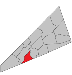
Location within Kings County, New Brunswick.
Country Flag of Canada (Pantone).svg  Canada
Province Flag of New Brunswick.svg  New Brunswick
County Kings County
Erected1870
Area
[1]
  Land7.26 km2 (2.80 sq mi)
Population
 (2021) [1]
  Total342
  Density47.1/km2 (122/sq mi)
  Change 2016-2021
Increase2.svg 5.2%
  Dwellings
134
Time zone UTC-4 (AST)
  Summer (DST) UTC-3 (ADT)
Figures do not include portion within the towns of Quispamsis and Rothesay

Rothesay is a geographic parish in Kings County, New Brunswick, Canada. [2]

Contents

Prior to the 2023 governance reform, it was divided for governence purposes between the towns of Rothesay and Quispamsis [3] and the local service district of the parish of Rothesay, [4] all of which were members of the Fundy Regional Service Commission (FRSC). [5]

Origin of name

The parish may been named in honour of the Duke of Rothesay, one of the hereditary titles of the Prince of Wales, who visited the area in 1860 [6] as part of his tour of North America.

History

Rothesay was erected from Hampton Parish in 1870. [7]

In 1873 the boundary with Hampton was clarified among the islands of Hammond River and altered to run along grant lines on the mainland. [8]

Boundaries

Rothesay Parish is bounded: [2] [9] [10] [11]

Communities

Communities at least partly within the parish; [9] [10] [11] bold indicates an incorporated municipality

Bodies of water

Bodies of water [lower-alpha 1] at least partly in the parish: [9] [10] [11]

Conservation areas

Parks, historic sites, and related entities in the parish. [9] [10] [11]

Demographics

Parish population total does not include Quispamsis and the town of Rothesay

Access Routes

Highways and numbered routes that run through the parish, including external routes that start or finish at the parish limits: [15]

See also

Notes

  1. Not including brooks, ponds or coves.

Related Research Articles

<span class="mw-page-title-main">Moncton Parish, New Brunswick</span> Parish in New Brunswick, Canada

Moncton is a geographic parish in Westmorland County, New Brunswick, Canada.

<span class="mw-page-title-main">Queensbury Parish, New Brunswick</span> Parish in New Brunswick, Canada

Queensbury is a geographic parish in York County, New Brunswick, Canada.

<span class="mw-page-title-main">Dumfries Parish, New Brunswick</span> Parish in New Brunswick, Canada

Dumfries is a geographic parish in York County, New Brunswick, Canada.

<span class="mw-page-title-main">Saint-François Parish, New Brunswick</span> Parish in New Brunswick, Canada

Saint-François is a geographic parish in Madawaska County, New Brunswick, Canada.

<span class="mw-page-title-main">Lac Baker Parish, New Brunswick</span> Parish in New Brunswick, Canada

Lac Baker is a geographic parish in Madawaska County, New Brunswick, Canada.

<span class="mw-page-title-main">Saint-Hilaire Parish, New Brunswick</span> Parish in New Brunswick, Canada

Saint-Hilaire is a geographic parish in Madawaska County, New Brunswick, Canada.

<span class="mw-page-title-main">Saint-Basile Parish, New Brunswick</span> Parish in New Brunswick, Canada

Saint-Basile is a geographic parish in Madawaska County, New Brunswick, Canada.

<span class="mw-page-title-main">Saint-Léonard Parish, New Brunswick</span> Parish in New Brunswick, Canada

Saint-Léonard is a geographic parish in Madawaska County, New Brunswick, Canada.

<span class="mw-page-title-main">Rogersville Parish, New Brunswick</span> Parish in New Brunswick, Canada

Rogersville is a geographic parish in Northumberland County, New Brunswick, Canada.

<span class="mw-page-title-main">Drummond Parish, New Brunswick</span> Parish in New Brunswick, Canada

Drummond is a geographic parish in Victoria County, New Brunswick, Canada.

<span class="mw-page-title-main">Denmark Parish, New Brunswick</span> Parish in New Brunswick, Canada

Denmark is a geographic parish in Victoria County, New Brunswick, Canada.

<span class="mw-page-title-main">Simonds Parish, Carleton County, New Brunswick</span> Parish in New Brunswick, Canada

Simonds is a geographic parish in Carleton County, New Brunswick, Canada, located north of Woodstock on the western bank of the Saint John River.

<span class="mw-page-title-main">Canterbury Parish, New Brunswick</span> Parish in New Brunswick, Canada

Canterbury is a geographic parish in York County, New Brunswick, Canada.

<span class="mw-page-title-main">Prince William Parish, New Brunswick</span> Parish in New Brunswick, Canada

Prince William is a geographic parish in York County, New Brunswick, Canada.

<span class="mw-page-title-main">Saint Andrews Parish, New Brunswick</span> Parish in Canada

Saint Andrews Parish is a geographic parish in Charlotte County, New Brunswick, Canada, located east of St. Stephen.

<span class="mw-page-title-main">Hampton Parish, New Brunswick</span> Parish in New Brunswick, Canada

Hampton is a geographic parish in Kings County, New Brunswick, Canada.

<span class="mw-page-title-main">Westfield Parish, New Brunswick</span> Parish in New Brunswick, Canada

Westfield is a geographic parish in Kings County, New Brunswick, Canada.

<span class="mw-page-title-main">Kingston Parish, New Brunswick</span> Parish in New Brunswick, Canada

Kingston is a geographic parish in Kings County, New Brunswick, Canada.

<span class="mw-page-title-main">Saint Croix Parish, New Brunswick</span> Parish in Canada

Saint Croix is a geographic parish in Charlotte County, New Brunswick, Canada, straddling Route 1 to the north of the original town of Saint Andrews.

<span class="mw-page-title-main">Saint Stephen Parish, New Brunswick</span> Parish in Canada

Saint Stephen is a geographic parish in Charlotte County, New Brunswick, Canada, located in the southwestern corner of the province.

References

  1. 1 2 "Census Profile". Statistics Canada. 26 October 2022. Retrieved 30 October 2022.
  2. 1 2 "Chapter T-3 Territorial Division Act". Government of New Brunswick. Retrieved 13 November 2020.
  3. "New Brunswick Regulation 85-6 under the Municipalities Act (O.C. 85-45)". Government of New Brunswick. Retrieved 19 July 2020.
  4. "New Brunswick Regulation 84-168 under the Municipalities Act (O.C. 84-582)". Government of New Brunswick. Retrieved 19 July 2020.
  5. "Communities in each of the 12 Regional Service Commissions (RSC) / Les communautés dans chacune des 12 Commissions de services régionaux (CSR)" (PDF), Government of New Brunswick, July 2017, retrieved 2 February 2021
  6. Ganong, William F. (1896). A Monograph of the Place-Nomenclature of the Province of New Brunswick. Royal Society of Canada. p. 266. Retrieved 17 March 2021.
  7. "33 Vic. c. 56 An Act to erect a part of the Parish of Hampton, in King's County, into a separate Town or Parish.". Acts of the General Assembly of Her Majesty's Province of New Brunswick Passed in the Months of March & April 1870. Fredericton: Government of New Brunswick. 1870. pp. 112–115. Available as a free ebook from Google Books.
  8. "36 Vic. c. 76 An Act to alter the division line between the Parishes of Hampton and Rothesay in the County of King's County.". Acts of the General Assembly of Her Majesty's Province of New Brunswick. Passed in the Months of March & April 1873. Fredericton: Government of New Brunswick. 1873. pp. 254–255. Available as a free ebook from Google Books.
  9. 1 2 3 4 "No. 149". Provincial Archives of New Brunswick. Department of Natural Resources and Energy Development. Retrieved 14 June 2021. Remainder of parish on map 157 at same site.
  10. 1 2 3 4 "446" (PDF). Transportation and Infrastructure. Government of New Brunswick. Retrieved 14 June 2021. Remainder of parish on mapbooks 460, 461, 473, and 474 at same site.
  11. 1 2 3 4 "Search the Canadian Geographical Names Database (CGNDB)". Government of Canada. Retrieved 14 June 2021.
  12. Statistics Canada: 2001, 2006 census
  13. 2011 Statistics Canada Census Profile: Rothesay Parish, New Brunswick
  14. 1 2 "Census Profile, 2016 Census: Rothesay, Parish [Census subdivision], New Brunswick". Statistics Canada. Retrieved 19 September 2019.
  15. Atlantic Canada Back Road Atlas ISBN   978-1-55368-618-7


45°22′53″N65°58′14″W / 45.381301°N 65.970583°W / 45.381301; -65.970583 (Rothesay Parish, New Brunswick)