Sabarkantha district

Last updated
Sabarkantha district
Roda Temples-17.jpg
Shrimad Rajchandra Vihar Idar12.jpg
Tower Chok Himmatnagar.jpg
Brahmaji Temple of Khedbrahma5.jpg
Mysterious lost temple of polo forest.jpg
Clockwise from top-left: Roda Temples, Rajchandra Vihara, Idar, Brahma Temple, Khedbrahma, Abhapur temples in Polo Forest, Tower Chowk, Himatnagar
Sabarkantha district
Interactive Map Outlining Sabarkantha District
Sabarkantha in Gujarat (India).svg
Location of district in Gujarat
Coordinates: 23°36′N72°57′E / 23.600°N 72.950°E / 23.600; 72.950
CountryFlag of India.svg  India
State Gujarat
Headquarters Himatnagar
Area
  Total5,390 km2 (2,080 sq mi)
Population
 (2011)
  Total1,388,671
  Density260/km2 (670/sq mi)
Languages
  Official Gujarati, Hindi
Time zone UTC+5:30 (IST)
ISO 3166 code GJ-IN
Vehicle registration GJ-9
Website sabarkantha.nic.in

Sabarkantha district is one of the 33 districts of Gujarat state of India, located in the northeastern part of the state. [1] The administrative headquarters of the district are located in Himatnagar. [1]

Contents

At a glance

The General outline of the district: [2]

Geography

Harnav dam Harnav dam.jpg
Harnav dam
Himatnagar Public Library Himatnagar Public Library and Towerclock.jpg
Himatnagar Public Library

Sabarkantha District is bounded by Rajasthan state to the north and northeast, Banaskantha district and Mehsana district to the west, Gandhinagar district to the south and Aravalli district to the southeast. [3]

It is spread across an area of 5390 km2. It has a gender ratio of 950 females per 1000 men, and the literacy rate for the district is 76.6%.

History

During the Western Satrap rule, the region was known as Shwabhra (Gujarati : શ્વભ્ર). The region was under the rule of Satrap Rudradama in 150 A.D. as indicated in Ashoka's Major Rock Edicts at Junagadh. The river of the region was originally named Shwabhravati and is now known as the Sabarmati River. The region is also named in auxiliary text Gaṇapāṭha of Pāṇini's grammar work, Aṣṭādhyāyī. [4]

During the British Raj Vijaynagar in Sabarkantha district was the capital of Vijaynagar State or Pol State, one of the princely states of the Mahi Kantha Agency. [5]

The present-day district of Sabarkantha was formed in 1949 through the merger of 29 princely states and some parts of the British-governed Ahmedabad district. [6] When the erstwhile Bombay state was bifurcated in 1960, Sabarkantha became a part of the newly-formed Gujarat. [6]

Economy

In 2006 the Ministry of Panchayati Raj named Sabarkantha one of the country's 250 most backward districts (out of a total of 640). [7] It is one of the six districts in Gujarat currently receiving funds from the Backward Regions Grant Fund Programme (BRGF). [7]

Divisions

Sabarkantha district has 8 talukas: [8]

  1. Himatnagar
  2. Idar
  3. Prantij
  4. Talod
  5. Khedbrahma
  6. Poshina
  7. Vadali
  8. Vijaynagar

Demographics

According to the 2011 census Sabarkantha district has a population of 2,428,589, [9] roughly equal to the nation of Kuwait [10] or the US state of New Mexico. [11] This gives it a ranking of 183rd in India (out of a total of 640). The district has a population density of 328 inhabitants per square kilometre (850/sq mi). Its population growth rate over the decade 2001-2011 was 16.56%. Sabarkantha has a sex ratio of 950 females for every 1000 males, and a literacy rate of 76.6%.

The residual district had a population of 1,388,671, of which 237,158 (17.08%) lived in urban areas. Residual Sabarkantha district had a sex ratio of 951 females per 1000 males. Scheduled Castes and Scheduled Tribes made up 125,462 (9.03%) and 328,243 (23.64%) of the population respectively. [9]

Religions in Sabarkantha district (2011) [12]
ReligionPercent
Hinduism
92.55%
Islam
6.48%
Jainism
0.72%
Other or not stated
0.25%

Hindus are 1,285,218, Muslims are 90,027 and Jains are 9,990. [12]

Language

Languages of Sabarkantha district (2011) [13]

   Gujarati (97.85%)
   Hindi (1.63%)
  Others (0.52%)

At the time of the 2011 Census of India, 97.85% of the population in the district spoke Gujarati and 1.63% Hindi as their first language. [13]

Politics

DistrictNo.ConstituencyNamePartyRemarks
Sabarkantha 27 Himatnagar VinendraSinh Zala (V D Zala) Bharatiya Janata Party
28 Idar (SC) Ramanlal Vora Bharatiya Janata Party
29 Khedbrahma (ST) Dr. Tushar Chaudhary Indian National Congress
Sabarkantha 33 Prantij Gajendrasinh Parmar Bharatiya Janata Party

Forts

Idario Gadh - Ilva Durga (ancient fort) – Idar is an ancient fort, known as 'Ilva Durga' and finds mentioned in Mahabharat and in the travelogue of the Rathore Rajputs in the Mahi Kantha agency at the time of British Raj. It is a classic example of a naturally protected hill fort, located at the southern edge of the Aravalli range. At the foothill, lay the ruins of an old palace, a fine specimen of architecture in stone with delicately carved balconies. The entry to Idar town is through a three storeyed clock tower cum entrance gate, with a huge arch and semi circular dome at the top. The road, with a colourful bazaar on both sides, leads to the tower and ends at the foothills of Idar fort. [14]

Villages

Heritage sites

Sharneshwar Temple in Abhapur Jain Temple, Polo Forest.jpg
Sharneshwar Temple in Abhapur

Vijay Villas Vijaynagar

Vijay Villas Vijaynagar is nested on the foothills of the aravali ranges and is on the edge of among the few dense forests left in Gujarat in the Sabarkantha district which is on the border of Gujarat and Rajasthan. It is a heaven for nature and wild life admirers. [16]

Darbargadh

About 18 km from Ambaji in Sabarkantha district, Poshina takes one back to the simple beauty of traditional village life, populated by a captivating mélange of colorful tribal communities of the Garasias, Bhils and the pastoral Rabaris. Poshina is home to a tribal shrine where you find the staggering scene of thousands of terracotta horses standing in rows as offerings to the local goddess. Nearby villages have similar horses carved in reverence to her divinity. A visit to the homes of the potters who make these striking horses is an excellent glimpse into tribal culture.

In Poshina you find the Darbargadh Poshina, once a palace, and now a welcoming heritage hotel, with huge gateways, a massive dome, numerous pillars and arches, a pleasant courtyard, gardens, lawns and terraces, owned by the descendants of the Chalukyas, whose empire spread through much of Gujarat and Central India in the 12th century. You also find old Jain sandstone temples of Parshvanath and Neminath and an old Shiva temple.

Sabarkantha district is host to the famous Chitra Vichitra Fair in Gunbhakhari village, a couple of weeks after Holi. [17]

Polo forest

Polo Forest Polo forest Vijaynagar.jpg
Polo Forest

Polo forest is spread across 400 square KM, located near Abhapur village in Vijaynagar taluka of Gujarat. Polo forest is surrounded by beautiful hills from where the Harnav River is crossing and spread across the forest, ancient Shiv temple, Jain temple and other heritage site located in nearby areas, Every year, Gujarat government celebrate Polo festival by organizing well-planned travel events which includes adventure activities, cycling, camping. [18]

Notable people

See also

Related Research Articles

<span class="mw-page-title-main">Banaskantha district</span> District of Gujarat in India

Banaskantha district is one of the thirty-three districts of the Gujarat state of India. The administrative headquarters of the district is at Palanpur which is also its largest city. The district is located in the Northeast of Gujarat and is presumably named after the West Banas River which runs through the valley between Mount Abu and Aravalli Range, flowing to the plains of Gujarat in this region and towards the Rann of Kutch. The district is famous for the Ambaji temple which draws many tourists. It covers an area of 12703 km2 and is the second largest district in the state.

<span class="mw-page-title-main">Idar, Gujarat</span> Town in Gujarat, India

Idar is a town in Sabarkantha district, Gujarat, India. It is known for the manufacture of handmade wooden toys, tiles, its temples and various beautiful architectural monuments on its hills, and its historical background. Idar is at the southern end of the Aravalli Range.

<span class="mw-page-title-main">Palanpur</span> City in Gujarat, India

Palanpur is a city and a municipality of Banaskantha district in the Indian state of Gujarat. Palanpur is the administrative headquarters of Banaskantha district. Palanpur is the ancestral home to an industry of Indian diamond merchants.

<span class="mw-page-title-main">Himatnagar</span> City in Gujarat, India

Himatnagar or Himmatnagar is a municipality in Sabarkantha district in the Indian state of Gujarat. It is the administrative headquarters of the district. The city is on the bank of the river Hathmati.

Ambaji (Ambājī) is a census town in Banaskantha district in the state of Gujarat, India.

Vadgam is located in India, situated in Banaskantha district in northern Gujarat. Administratively, it is a Taluka. There are 110 villages under this Taluka. Vadgam region also known as a Dhandhar.

<span class="mw-page-title-main">Kalol, Gandhinagar</span> City in Gujarat, India

Kalol is a city in Gandhinagar district in the Indian state of Gujarat, located alongside Gujarat State Highway 41 between the cities of Mehsana and Ahmedabad.

<span class="mw-page-title-main">Khedbrahma</span> Town in Gujarat, India

Khedbrahma is a town and a taluka headquarter in Khedbrahma Taluka of Sabarkantha district, Gujarat, India. It is situated on the banks of Harnav river. The town is connected with mythological history and has been pilgrim site for centuries. The 11th century Brahma, Ambika and Pankhnath Mahadev temples are the oldest monuments of the town. The town has an old stepwell, the Brahma Vav. It was under Parmaras, Chaulukyas and Pariharas before it came under Idar State in 13th century.

North Gujarat, the Northern part of Indian state of Gujarat includes the districts of Gandhinagar, Banaskantha, Patan, Aravalli, Mehsana, and Sabarkantha.

Bhiloda is a taluka headquarters situated in Aravalli District in the state of Gujarat, India. It is situated on the banks of the Hathmati River among the Aravalli Hills.

<span class="mw-page-title-main">Aravalli district</span> District of Gujarat in India

Aravalli district is a district in the state of Gujarat in India that came into being on August 15, 2013, becoming the 29th district of the state. The district has been carved out of the Sabarkantha district. The district headquarters are at Modasa.

<span class="mw-page-title-main">Vijaynagar State</span>

Vijaynagar State, known as Pol State before 1934 and also called Ghodadar for a short time, was a princely state under the Mahi Kantha Agency, Bombay Presidency in NE Gujarat during the British Raj. The capital of the state was in Vijaynagar taluka, Sabarkantha district. The state's last ruler signed the accession to the Indian Union on 10 June 1948.

<span class="mw-page-title-main">Kumbhariya, Banaskantha district</span> Village in Gujarat, India

Kumbhariya is a village of historical, archaeological and religious importance with cultural heritage in Danta Taluka of Banaskantha district, Gujarat, India.

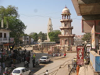
Vadali is a town in Vadali Taluka of Sabarkantha district of Gujarat, India.

Idar railway station is a small railway station in Sabarkantha district, Gujarat, India. Its code is IDAR. It serves Idar city. The station consists of two platforms. The platforms are not well sheltered. It lacks many facilities including water and sanitation. Idar lies on former metre-gauge track of Khedbrahma–Himatnagar–Ahmedabad. The line is closed since 2017.

Jagana is a village in the Palanpur taluka of Banaskantha district in northern Gujarat, India. The villages Vasna, Bhagal, Sedrasana are located near to Jagana and it is just 6 km away from the district headquarters, Palanpur.

<span class="mw-page-title-main">2017 Gujarat flood</span> Floods in India

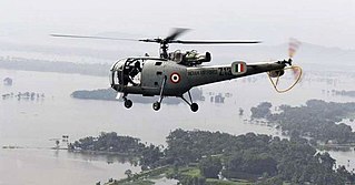
Following heavy rain in July 2017, the Indian state of Gujarat was affected by severe flooding. The floods were reported to have caused total 224 deaths between 1 June and 31 July 2017. 16 people had died in neighbouring Rajasthan state by 31 July.

<span class="mw-page-title-main">Polo Forest</span> Dry mixed deciduous forest in Gujarat, India

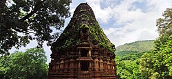
Polo forest, also known as Vijaynagar forest, is a dry mixed deciduous forest near Abhapur village in Vijaynagar Taluka, Sabarkantha district, Gujarat, India. It is located at the foothills of the Aravalli range and on the banks of perennial Harnav river, spread over the area of 400 square kilometres.

<span class="mw-page-title-main">Meshwo River</span> River

Meshwo or Meshwa is a river flowing in north and central parts Gujarat, state of India. Meshwo is the tributary river of the Sabarmati and subtribunary of the Vatrak River. It rises in the Panchara hills of Aravalli range, in the Dungarpur district of Rajasthan and enters in Gujarat at Shamlaji.

References

  1. 1 2 "Districts of Gujarat". Districts of India. National Informatics Centre. Retrieved 8 April 2019.
  2. "Outline of Sabarkatha". sabarkanthadp.gujarat.gov.in. Archived from the original on 2010-03-25.
  3. District Census Handbook Sabar Kantha Part XII-B (PDF). Directorate of Census Operations. 2011. Retrieved 8 April 2019.
  4. Shukla, Jaykumar R. Shwabhra, Gujarati Vishwakosh, p. 754.
  5. Rajput Provinces of India - Vijaynagar State (Princely State)
  6. 1 2 Rajyagor, S B (1974). Gujarat State Gazetteers Sabarkantha District. Ahmedabad: Director, Government Printing. Retrieved 8 April 2019.
  7. 1 2 Ministry of Panchayati Raj (September 8, 2009). "A Note on the Backward Regions Grant Fund Programme" (PDF). National Institute of Rural Development. Archived from the original (PDF) on April 5, 2012. Retrieved September 27, 2011.
  8. "Villages & Panchayats | District Sabarkantha, Government of Gujarat | India" . Retrieved 2021-08-19.
  9. 1 2 "District Census Hand Book – Sabarkantha" (PDF). Census of India . Registrar General and Census Commissioner of India.
  10. US Directorate of Intelligence. "Country Comparison:Population". Archived from the original on June 13, 2007. Retrieved 2011-10-01. Kuwait 2,595,62
  11. "2010 Resident Population Data". U. S. Census Bureau. Retrieved 2011-09-30. New Mexico - 2,059,179
  12. 1 2 "Population by Religion - Gujarat". censusindia.gov.in. Registrar General and Census Commissioner of India. 2011.
  13. 1 2 "Table C-16 Population by Mother Tongue: Gujarat". censusindia.gov.in. Registrar General and Census Commissioner of India.
  14. "Gujarat State Portal".
  15. "Takhatgadh Pin Code". indiatvnews.com. Independent News Service. Retrieved 16 June 2023.
  16. "Archived copy". Archived from the original on 2012-01-09. Retrieved 2014-03-22.{{cite web}}: CS1 maint: archived copy as title (link)
  17. "Poshina | Nearby places | Ambaji | North Gujarat (Ahmedabad) | Tourism Hubs | Home | Gujarat Tourism". Archived from the original on 2014-03-22. Retrieved 2014-03-22.
  18. "Polo Forest - Pictures, Timing, Fees and How to Visit from Ahmedabad in Gujarat".