Saint-Basile Parish, New Brunswick

Last updated

Saint-Basile
St. Basil, St. Basile
Madawaska County NB - Saint-Basile Parish.PNG
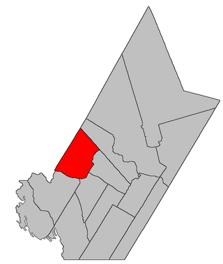
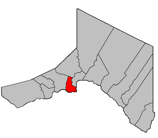
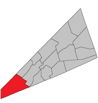
Location within Madawaska County.
Coordinates: 47°21′36″N68°15′18″W / 47.36°N 68.255°W / 47.36; -68.255
Country Flag of Canada (Pantone).svg  Canada
Province Flag of New Brunswick.svg  New Brunswick
County Madawaska
Erected1850
Area
[1]
  Land129.96 km2 (50.18 sq mi)
Population
 (2021) [1]
  Total736
  Density4.6/km2 (12/sq mi)
  Change 2016-2021
Decrease2.svg 24.3%
  Dwellings
342
Time zone UTC-4 (AST)
  Summer (DST) UTC-3 (ADT)
Figures do not include portions within the city of Edmundston and the St. Basile 10 Indian reserve

Saint-Basile is a geographic parish in Madawaska County, New Brunswick, Canada. [4]

Contents

For governance purposes it is divided between the city of Edmundston, [5] the St. Basile 10 Indian Reserve, and the Northwest rural district; [6] the city and rural district are members of the Northwest Regional Service Commission. [7]

Before the 2023 governance reform, the area now in the rural district formed the local service district of the parish of Saint-Basile. [8]

Origin of name

The parish was named for the Roman Catholic church. [9]

History

Saint-Basile was erected as Saint Basil in 1850 from Madawaska Parish. [10]

In 1852 the parish's boundaries were extended northward to include territory awarded in the boundary settlement with the Province of Canada. [11]

In 1874 the core of modern Edmundston was removed from Saint-Basile and added to Madawaska Parish. [12]

In 1877 the newly erected Sainte-Anne Parish included part of Saint-Basile. [13]

In 1896 the boundary along Green River was altered. [14]

In 1920 part of Saint-Basile was erected as Rivière-Verte Parish. [15]

In 1973 the name was officially changed to Saint-Basile. [16]

Boundaries

Saint-Basile Parish is bounded: [2] [17] [18] [19]

Communities

Communities at least partly within the parish. [17] [18] [19] bold indicates an incorporated municipality or Indian reserve; italics indicate a name no longer in official use

Bodies of water

Bodies of water [lower-alpha 3] at least partly in the parish. [17] [18] [19]

Islands

Islands at least partly in the parish. [17] [18] [19]

Demographics

Parish population total does not include Indian reserve or portion in Edmundston

Population

Canada census – Saint-Basile community profile
2021 2016 2011
Population736 (+24.3% from 2016)592 (-17.4% from 2011)717 (-10.3% from 2006)
Land area129.96 km2 (50.18 sq mi)129.61 km2 (50.04 sq mi)129.74 km2 (50.09 sq mi)
Population density5.7/km2 (15/sq mi)4.6/km2 (12/sq mi)5.5/km2 (14/sq mi)
Median age51.2 (M: 51.6, F: 51.2)47.5 (M: 48.0, F: 47.1)44.7 (M: 46.1, F: 42.9)
Private dwellings325 (total) 270 (total) 313 (total) 
Median household income$58,048$46,535
References: 2021 [22] 2016 [23] 2011 [24] earlier [25] [26]
Historical Census Data
Saint-Basile Parish, New Brunswick
YearPop.±%
1991 694    
1996 672−3.2%
YearPop.±%
2001 705+4.9%
2006 799+13.3%
YearPop.±%
2011 717−10.3%
2016 592−17.4%
[27] [28]

Language

Canada Census Mother Tongue - Saint-Basile Parish, New Brunswick [27]
CensusTotal
French
English
French & English
Other
YearResponsesCountTrendPop %CountTrendPop %CountTrendPop %CountTrendPop %
2011
715
695Decrease2.svg 11.5%97.20%20Increase2.svg 33.3%2.80%0Steady2.svg 0.0%0.00%0Steady2.svg 0.0%0.00%
2006
800
785Increase2.svg 18.9%98.13%15Steady2.svg 0.0%1.87%0Decrease2.svg 100.0%0.00%0Steady2.svg 0.0%0.00%
2001
710
660Increase2.svg 1.5%92.96%15Increase2.svg 50.0%2.11%35Increase2.svg 250.0%4.93%0Steady2.svg 0.0%0.00%
1996
670
650n/a97.01%10n/a1.49%10n/a1.49%0n/a0.00%

See also

Notes

  1. The English name Green River and the French name Rivière Verte are both official. [20]
  2. The Territorial Act has an overlap of Saint-Basile and Saint-Joseph Parish; this is due to Saint-Basile being omitted from the 1946 rewrite of parish boundaries in Madawaska County. [21] The wording of the 1946 Act gave the Saint-Joseph boundaries precedence and the wording of the northwestern boundary of Saint-Basile has never been corrected.
  3. Not including brooks, ponds or coves.

Related Research Articles

<span class="mw-page-title-main">Southampton Parish, New Brunswick</span> Parish in New Brunswick, Canada

Southampton is a geographic parish in York County, New Brunswick, Canada.

<span class="mw-page-title-main">Paquetville Parish, New Brunswick</span> Parish in New Brunswick, Canada

Paquetville is a geographic parish in Gloucester County, New Brunswick, Canada.

<span class="mw-page-title-main">Saint-François Parish, New Brunswick</span> Parish in New Brunswick, Canada

Saint-François is a geographic parish in Madawaska County, New Brunswick, Canada.

<span class="mw-page-title-main">Lac Baker Parish, New Brunswick</span> Parish in New Brunswick, Canada

Lac Baker is a geographic parish in Madawaska County, New Brunswick, Canada.

<span class="mw-page-title-main">Clair Parish, New Brunswick</span> Parish in New Brunswick, Canada

Clair is a geographic parish in Madawaska County, New Brunswick, Canada.

<span class="mw-page-title-main">Baker Brook Parish, New Brunswick</span> Parish in New Brunswick, Canada

Baker Brook is a geographic parish in Madawaska County, New Brunswick, Canada.

<span class="mw-page-title-main">Saint-Hilaire Parish, New Brunswick</span> Parish in New Brunswick, Canada

Saint-Hilaire is a geographic parish in Madawaska County, New Brunswick, Canada.

<span class="mw-page-title-main">Madawaska Parish, New Brunswick</span> Parish in New Brunswick, Canada

Madawaska is a geographic parish in Madawaska County, New Brunswick, Canada.

<span class="mw-page-title-main">Saint-Jacques Parish, New Brunswick</span> Parish in New Brunswick, Canada

Saint-Jacques is a geographic parish in Madawaska County, New Brunswick, Canada. The parish consists of two discontiguous portions separated by Saint-Joseph Parish.

<span class="mw-page-title-main">Saint-Joseph Parish, New Brunswick</span> Parish in New Brunswick, Canada

Saint-Joseph is a geographic parish in Madawaska County, New Brunswick, Canada.

<span class="mw-page-title-main">Rivière-Verte Parish, New Brunswick</span> Parish in New Brunswick, Canada

Rivière-Verte is a geographic parish in Madawaska County, New Brunswick, Canada.

<span class="mw-page-title-main">Sainte-Anne Parish, New Brunswick</span> Parish in New Brunswick, Canada

Sainte-Anne is a geographic parish in Madawaska County, New Brunswick, Canada.

<span class="mw-page-title-main">Notre-Dame-de-Lourdes Parish, New Brunswick</span> Parish in New Brunswick, Canada

Notre-Dame-de-Lourdes is a geographic parish in Madawaska County, New Brunswick, Canada.

<span class="mw-page-title-main">Saint-Léonard Parish, New Brunswick</span> Parish in New Brunswick, Canada

Saint-Léonard is a geographic parish in Madawaska County, New Brunswick, Canada.

<span class="mw-page-title-main">Saint-André Parish, New Brunswick</span> Parish in New Brunswick, Canada

Saint-André is a geographic parish in Madawaska County, New Brunswick, Canada.

<span class="mw-page-title-main">Drummond Parish, New Brunswick</span> Parish in New Brunswick, Canada

Drummond is a geographic parish in Victoria County, New Brunswick, Canada.

<span class="mw-page-title-main">Sainte-Marie Parish, New Brunswick</span> Parish in New Brunswick, Canada

Saint-Marie, is a geographic parish in Kent County, New Brunswick, Canada.

<span class="mw-page-title-main">Hampton Parish, New Brunswick</span> Parish in New Brunswick, Canada

Hampton is a geographic parish in Kings County, New Brunswick, Canada.

<span class="mw-page-title-main">Westfield Parish, New Brunswick</span> Parish in New Brunswick, Canada

Westfield is a geographic parish in Kings County, New Brunswick, Canada.

<span class="mw-page-title-main">Kingston Parish, New Brunswick</span> Parish in New Brunswick, Canada

Kingston is a geographic parish in Kings County, New Brunswick, Canada.

References

  1. 1 2 "Census Profile". Statistics Canada. 26 October 2022. Retrieved 30 October 2022.
  2. 1 2 "Chapter T-3 Territorial Division Act". Government of New Brunswick. Retrieved 24 January 2023.
  3. "Chapter I-13 Interpretation Act". Government of New Brunswick. Retrieved 24 January 2023.
  4. The Territorial Division Act [2] divides the province into 152 parishes, the cities of Saint John and Fredericton, and one town of Grand Falls. The Interpretation Act [3] clarifies that parishes include any local government within their borders.
  5. "Northwest Regional Service Commission: RSC 1". Government of New Brunswick. Retrieved 24 January 2023.
  6. "Northwest Regional Service Commission: RD 1". Government of New Brunswick. Retrieved 24 January 2023.
  7. "Regions Regulation – Regional Service Delivery Act". Government of New Brunswick. 21 July 2022. Retrieved 24 January 2023.
  8. "Local Service Districts Regulation - Municipalities Act". Government of New Brunswick. 25 June 2021. Retrieved 24 January 2023.
  9. Ganong, William F. (1896). A Monograph of the Place-Nomenclature of the Province of New Brunswick. Royal Society of Canada. p. 267. Retrieved 17 March 2021.
  10. "13 Vic. c. 51 An Act to consolidate all the Laws now in force for the division of the Province into Counties, Towns and Parishes.". Acts of the General Assembly of Her Mjaesty's Province of New Brunswick, Passed in the Year 1850. Fredericton: Government of New Brunswick. 1850. pp. 142–152, 145–149. Retrieved 27 March 2021. Book was poorly proofread, resulting in title typo and reuse of page numbers 145–152.
  11. "15 Vic. c. 6 An Act to annex the Territory awarded to this Province by the New Brunswick and Canadian Arbitrators in the recent settlement of the Boundary question between the Provinces of New Brunswick and Canada, to the Counties of Victoria and Restigouche, and to alter the present Boundary Line between these counties.". Acts of the General Assembly of Her Majesty's Province of New Brunswick, Passed in the Year 1852. Fredericton: Government of New Brunswick. 1852. pp. 4–5. Retrieved 27 March 2021.
  12. "37 Vic. c. 47 An Act to include certain Lands in the Parish of Saint Basil in the Parish of Madawaska, in the County of Madawaska.". Acts of the General Assembly of Her Majesty's Province of New Brunswick. Passed in the Months of March & April 1874. Fredericton: Government of New Brunswick. 1874. p. 129. Available as a free ebook from Google Books.
  13. "40 Vic. c. 30 An Act to erect parts of the Parishes of Saint Leonard, Saint Basil, Madawaska, and Saint Francis, in the County of Madawaska, into three additional Parishes.". Acts of the General Assembly of Her Majesty's Province of New Brunswick. Passed in the Month of March 1877. Fredericton: Government of New Brunswick. 1877. pp. 125–128. Available as a free ebook from Google Books.
  14. "59 Vic. c. 8 An Act to Revise and Codify an Act to Provide for the Division of the Province into Counties, Towns and Parishes.". Acts of the General Assembly of Her Majesty's Province of New Brunswick. Passed in the Month of March, 1896. Fredericton: Government of New Brunswick. 1896. pp. 86–123. Available as a free ebook from Google Books.
  15. "9 Geo. V c. 55 An Act to amend Chapter 2 of the Consolidated Statutes, 1903, respecting the division of the Province into Counties, Towns and Parishes.". Acts of the Legislative Assembly of New Brunswick Passed in the Month of April 1919. Fredericton: Government of New Brunswick. 1919. pp. 258–265.
  16. "Chapter T-3 Territorial Division Act". Revised Statutes of New Brunswick 1973 Volume IV. Fredericton: Government of New Brunswick. 1973. pp. 1–70.
  17. 1 2 3 4 "No. 20". Provincial Archives of New Brunswick. Department of Natural Resources and Energy Development. Retrieved 16 June 2021. Remainder of parish on maps 33 and 34 at same site.
  18. 1 2 3 4 "079" (PDF). Transportation and Infrastructure. Government of New Brunswick. Retrieved 16 June 2021. Remainder of parish on mapbooks 098, 099, 120, and 121 at same site.
  19. 1 2 3 4 "Search the Canadian Geographical Names Database (CGNDB)". Government of Canada. Retrieved 16 June 2021.
  20. "Green River / Rivière Verte". Geographical names in Canada. Natural Resources Canada. Retrieved 7 March 2021.
  21. "10 Geo. VI. c. 95 An Act to amend Chapter 2 of the Revised Statutes, 1927, respecting the division of the Province into Counties, Towns and Parishes, in so far as it relates to the County of Madawaska.". Acts of the Legislative Assembly of New Brunswick Passed During the Session of 1946. Fredericton: Government of New Brunswick. 1946. pp. 321–339.
  22. "2021 Community Profiles". 2021 Canadian Census . Statistics Canada. 4 February 2022. Retrieved 27 April 2022.
  23. "2016 Community Profiles". 2016 Canadian Census . Statistics Canada. 12 August 2021. Retrieved 29 August 2019.
  24. "2011 Community Profiles". 2011 Canadian Census . Statistics Canada. 21 March 2019. Retrieved 28 March 2014.
  25. "2006 Community Profiles". 2006 Canadian Census . Statistics Canada. 20 August 2019.
  26. "2001 Community Profiles". 2001 Canadian Census . Statistics Canada. 18 July 2021.
  27. 1 2 Statistics Canada: 1996, 2001, 2006, 2011 census
  28. "Census Profile, 2016 Census Saint-Basile, Parish [Census subdivision], New Brunswick". Statistics Canada. Retrieved 29 August 2019.


47°21′36″N68°15′18″W / 47.36000°N 68.25500°W / 47.36000; -68.25500 (Saint-Basile Parish, New Brunswick)