
Marion County is located in the northern portion of the U.S. state of Florida. As of the 2020 census, the population was 375,908. Its county seat is Ocala.
Sumter County is a county located in the central portion of the U.S. state of Florida. As of the 2020 census, the population is 129,752. It has the oldest median age of any US county and the highest percentage of residents aged 65 and older—at 55.6% in 2014-2018. Its county seat is Bushnell, and the largest community is The Villages.
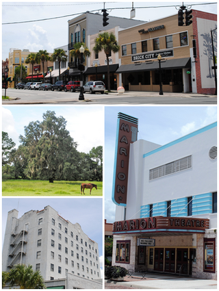
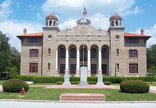
Ocala is a city in and the county seat of Marion County, Florida, United States. Located in North Florida, the city's population was 63,591 as of the 2020 census, making it the 54th-most populated city in Florida. Ocala is the principal city of the Ocala metropolitan area, which had a population of 375,908 in 2020.

Silver Springs Shores is a census-designated place (CDP) in Marion County, Florida, United States. The population was 24,846 at the 2020 census. It is part of the Ocala Metropolitan Statistical Area.

The Villages is a census-designated place (CDP) in Sumter and Marion counties in the U.S. state of Florida. It shares its name with a broader master-planned age-restricted community that spreads into portions of Lake County. The overall development lies in central Florida, approximately 20 miles (32 km) south of Ocala and approximately 45 miles (72 km) northwest of Orlando. As of the 2020 census, the population of the CDP was 79,077.
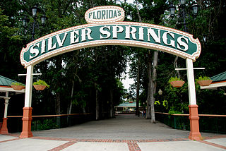
Silver Springs is an unincorporated community and census-designated place (CDP) in Marion County of northern Florida. It is the site of Silver Springs, a group of artesian springs and a historic tourist attraction that is now part of Silver Springs State Park. The community is part of the Ocala metropolitan area. It was first listed as a CDP for the 2020 census, at which time it had a population of 2,844.

Grayton Beach State Park is a Florida State Park located between Panama City Beach and Destin, near the unincorporated area of Grayton Beach, on CR 30A, in northwestern Florida. Its sister park is Deer Lake State Park.
Ponce de Leon Springs State Recreation Area is a Florida State Park in Holmes County, Florida, USA. It is located in the town of Ponce de Leon. The park, which was created to provide public outdoor recreation and other park-related uses, was initially acquired on September 4, 1970, using funds from the Land Acquisition Trust Fund. Its self-proclaimed purpose is to develop, operate and maintain the property for outdoor recreation, park, historic, and related purposes, offering abundant opportunity for nature appreciation and wildlife viewing. Its primary recreational activities include swimming in the spring and hiking along the park's nature trails.

The Ocala National Forest ls the second largest nationally protected forest in the U.S. State of Florida. It covers 607 square miles (1,570 km2) of northern Florida. It is located three miles (5 km) east of Ocala and 16 miles (26 km) southeast of Gainesville. The Ocala National Forest, established in 1908, is the oldest national forest east of the Mississippi River and the southernmost national forest in the continental U.S. The word Ocala is thought to be a derivative of a Timucuan term meaning "fair land" or "big hammock". The forest is headquartered in Tallahassee, as are all three National Forests in Florida, but there are local ranger district offices located in Silver Springs and Umatilla.

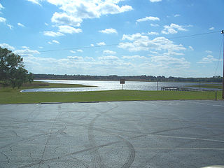
The 74-mile-long (119 km) Ocklawaha River flows north from central Florida until it joins the St. Johns River near Palatka. Its name is derived from ak-lowahe, Creek for "muddy".
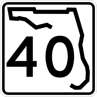
State Road 40 is a 91.832-mile-long (147.789 km) east–west route across northern and east-central Florida, running from U.S. Route 41 in Rainbow Lakes Estates eastwards through Ocala over the Ocklawaha River and bridge and through the heart of the Ocala National Forest to State Road A1A in Ormond Beach. Names of the road include Silver Springs Boulevard in Ocala, Fort Brooks Road from Silver Springs through Astor, Butler Road in Astor, and Granada Boulevard in Ormond Beach. Former sections in Ormond Beach are named "Old Tomoka Road" and "Old Tomoka Avenue."

Marion Oaks is an unincorporated community and census-designated place (CDP) in Marion County, Florida, United States. It is part of the Ocala Metropolitan Statistical Area. As of the 2020 census, the population was 19,034. The community is currently exploring becoming an incorporated city.
Rainbow Lakes Estates is an unincorporated community and census-designated place (CDP) in Marion and Levy counties, Florida, United States, established as a Municipal Services District. The Marion County part of the community is part of the Ocala metropolitan area, while the Levy County portion is part of the Gainesville metropolitan area. It was first listed as a CDP for the 2020 census, at which time it had a population of 3,438.

Juniper Springs, located in the Ocala National Forest east of Ocala, Florida, is a natural spring that forms the headwaters of Juniper Creek that winds its way to Lake George in the Saint Johns River.

State Road 19 is a Florida State Road in Putnam, Marion, and Lake counties. It runs from Groveland to Palatka through Ocala National Forest. Along with SR 33, SR 19 provides a mostly rural north-south corridor through central Florida from Lakeland to Palatka.

The Lake George State Forest is a designated protected area and state forest in the U.S. state of Florida. The 21,176-acre (8,570 ha) forest is located in northwestern Volusia County, Florida, near Lake George and the communities of Pierson, Barberville, and Volusia. It is overseen by the Florida Forest Service within the Florida Department of Agriculture and Consumer Services.

U.S. Route 441 (US 441) in Florida is a north–south United States Highway. It runs 433 miles (697 km) from Miami in South Florida northwest to Tennessee in the Rocky Top area.
Orange Creek is a small stream in north-central and northeast Florida, that drains Orange Lake to the Ocklawaha River. Privately owned Orange Springs provides part of the water volume.

Silver Glen Springs is a first-magnitude spring and the main attraction of the Silver Glen Springs Recreation Area of Ocala National Forest. It lies at the east edge of the national forest. It is about 2 miles north of the entrance of Juniper Creek, and it is along the edge of Big Scrub. There is a short spring run that is about 0.75 miles long and goes to Lake George.


