Prairies are ecosystems considered part of the temperate grasslands, savannas, and shrublands biome by ecologists, based on similar temperate climates, moderate rainfall, and a composition of grasses, herbs, and shrubs, rather than trees, as the dominant vegetation type. Temperate grassland regions include the Pampas of Argentina, Brazil and Uruguay, and the steppe of Ukraine, Russia and Kazakhstan. Lands typically referred to as "prairie" tend to be in North America. The term encompasses the area referred to as the Interior Lowlands of Canada, the United States, and Mexico, which includes all of the Great Plains as well as the wetter, hillier land to the east.

The Pecatonica River is a tributary of the Rock River, 194 miles (312 km) long, in southern Wisconsin and northern Illinois in the United States.

Rangelands are grasslands, shrublands, woodlands, wetlands, and deserts that are grazed by domestic livestock or wild animals. Types of rangelands include tallgrass and shortgrass prairies, desert grasslands and shrublands, woodlands, savannas, chaparrals, steppes, and tundras. Rangelands do not include forests lacking grazable understory vegetation, barren desert, farmland, or land covered by solid rock, concrete and/or glaciers.

The tallgrass prairie is an ecosystem native to central North America. Historically, natural and anthropogenic fire, as well as grazing by large mammals provided periodic disturbances to these ecosystems, limiting the encroachment of trees, recycling soil nutrients, and facilitating seed dispersal and germination. Prior to widespread use of the steel plow, which enabled large scale conversion to agricultural land use, tallgrass prairies extended throughout the American Midwest and smaller portions of southern central Canada, from the transitional ecotones out of eastern North American forests, west to a climatic threshold based on precipitation and soils, to the southern reaches of the Flint Hills in Oklahoma, to a transition into forest in Manitoba.

An oak savanna is a type of savanna—or lightly forested grassland—where oaks are the dominant trees. The terms "oakery" or "woodlands" are also used commonly, though the former is more prevalent when referencing the Mediterranean area. These savannas were maintained historically through wildfires set by lightning, humans, grazing, low precipitation, and/or poor soil.

The Northern California coastal forests are a temperate coniferous forests ecoregion of coastal Northern California and southwestern Oregon.
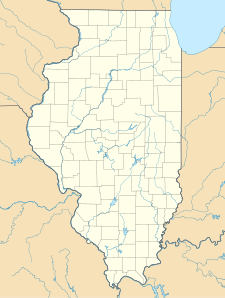
Sand Ridge State Forest is a conservation area located in the U.S. state of Illinois. Containing 7,200 acres (2,900 ha), it is the largest state forest in Illinois. It is located in northern Mason County. The nearest town is Manito, Illinois, and the nearest numbered highway is U.S. Highway 136. It is located on a low bluff, or "sand ridge", overlooking the Illinois River, hence the name. The sand ridge is believed to be an artifact of the post-glacial Kankakee Torrent.
Dwarf forest, elfin forest, or pygmy forest is an uncommon ecosystem featuring miniature trees, inhabited by small species of fauna such as rodents and lizards. They are usually located at high elevations, under conditions of sufficient air humidity but poor soil. There are two main dwarf forest ecosystem types, involving different species and environmental characteristics: coastal temperate and montane tropical regions. Temperate coastal dwarf forest is common for parts of Southern California. Montane tropical forests are found across tropical highlands of Central America, northern South America and Southeast Asia. There are also other isolated examples of dwarf forests scattered across the world, while the largest dwarf forest is found in the Philippines.
Spitler Woods State Natural Area is a 202.5-acre (81.9 ha) state park located adjacent to Mount Zion, Illinois. The state park is located within the Decatur, Illinois metropolitan area. The eastern two-thirds of the state park is a listed state natural area noted for its old-growth forest grove of white oak and hickory. The park is managed by the Illinois Department of Natural Resources (IDNR).
The Iroquois County State Wildlife Area is an Illinois state park that occupies 2,480 acres (1,004 ha) in northeastern Iroquois County, near the border with Indiana. The nearest municipality is Beaverville, Illinois, and the nearest exit on a limited-access highway is Exit 302 on Interstate 57.

Fults Hill Prairie State Natural Area, also known as the Fults Hill Prairie Nature Preserve, is an Illinois Nature Preserve on 997 acres (403 ha) in Monroe County, Illinois, United States. A key feature of the preserve is a 532-acre (215 ha) hill prairie located on the east bluff of the Mississippi River overlooking the American Bottom near Fults, Illinois. The Fults Hill Prairie has been listed as a National Natural Landmark.
Spread Eagle Barrens State Natural Area is a 7,155-acre (2,896 ha) protected area just off of U.S. 2 in Florence County, Wisconsin, USA. The nearest unincorporated community is Spread Eagle, Wisconsin, but the closest large city is Iron Mountain, Michigan; 6 miles (10 km) away. The Spread Eagle Barrens is owned by the Wisconsin Department of Natural Resources and the Wisconsin Energy Corporation, and was designated a State Natural Area in 1995.

Hoosier Prairie is a unit of Indiana Dunes National Park in Lake County, Indiana. It began in the 1970s as wasteland that conservation organization found of a unique interest. From a core of 304 acres (123 ha), it has grown to 1,547 acres (626 ha) of important prairie habitat. The area was designated a National Natural Landmark in 1974 and a State Nature Preserve in 1977 The sandy soil creates a variety of habitats, from oak barrens, wet prairie, including sedge meadows and prairie marshes. More than 350 native species of vascular plants have been identified. A minimum of 43 species are uncommon in the State of Indiana.

The Indiana Dunes comprise ten different habitats. Each provides for a unique combination of plants and animals. The range of the Indiana Dunes varies depending your source. The Indiana Lake Michigan Coastal Program uses the river drainage systems along the shoreline. This expands the area from the areas of lakeshore southward to the edges of the Valparaiso Moraine. This entire region has been dune landscapes since over 114,000 years before present (YBP). Traditionally, the Indiana Dunes area thought of as a narrow area along the shores of Lake Michigan, including the areas of Marquette Park in Gary, Indiana (1920), Indiana Dunes State Park (1926) and Indiana Dunes National Park,. The identified ten habitats can be found in these parks, where they have been preserved, but are also visible throughout the three counties of Northwest Indiana.

Conrad Savanna Nature Preserve is a 453-acre (183 ha) nature preserve located in Newton County, Indiana, 2.5 miles (4.0 km) south of Lake Village, just west of U.S. 41 on County Road 700 North. The savanna contains alternating rolling sand dunes and level areas. Typical of a savanna, it is covered by trees, grasses, and sedges. The dominant plants include Junegrass, Pennsylvania sedge, porcupine grass, little bluestem, Indian grass and big bluestem. The preserve is managed as by the Indiana Department of Natural Resources (IDNR).

The Interior Low Plateaus are a physiographic region in eastern United States. It consists of a diverse landscape that extends from north Alabama across central Tennessee and Kentucky into southern Illinois, Indiana, and Ohio. Its natural communities are a matrix of temperate forests, woodlands, and prairies.
Revis Hill Prairie State Natural Area, also known as Revis Hill Prairie Nature Preserve, is a 412.7-acre (167.0 ha) state park located six miles south of Easton in Mason County, Illinois. It is operated by the Illinois Department of Natural Resources (IDNR) as a tallgrass prairie nature preserve and as a fish and wildlife area managed for deer hunting.

The Southern Unit of the Kettle Moraine State Forest includes more than 22,000 acres of land throughout southern Wisconsin and spans several state parks and natural areas. The area also features varied environments from restored prairie, forests, and lakes, along with providing a multitude of recreational opportunities such as hiking, birdwatching, fishing, camping, and hunting. The Kettle Moraine Scenic Drive also extends within this region as well as through a larger portion of the state.
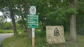
The Hobart Nature District is located in the City of Hobart, Indiana and encompasses over 1,000 acres of scenic parks, wetlands and floodplains, winding rivers, peaceful lakes, open prairies, oak savannas, old-growth forests, and undulating ravines.
Middlefork Savanna is a of 687 acres (278 ha) nature preserve in Lake Forest, Illinois. Several biomes including oak savannas, dry-mesic prairies, wet-mesic prairies, marshes, deciduous woodlands, and sedge meadows as well as a portion of the North Branch of the Chicago River are found in the preserve. The Middlefork Savanna also contains 25 acres (10 ha) of the “highest quality tallgrass savanna of its kind” in the United States. Such ecosystems are globally endangered. The preserve includes 5.5 miles of gravel trails for hiking and cross-country skiing as well as 4.2 miles of trails for biking. It is managed by Lake County Forest Preserves.