Williamson County is a county in Southern Illinois. At the 2020 census, it had a population of 67,153. The largest city and county seat is Marion.

Saline County is a county in Southern Illinois. At the 2020 census, it had a population of 23,768. The largest city and county seat is Harrisburg. This area of Southern Illinois is known locally as "Little Egypt".

Belknap is a village in Johnson County, Illinois, United States. The population was 104 at the 2010 census.

Cypress is a village in Johnson County, Illinois, United States. The population was 234 at the 2010 census.

New Burnside is a village in Johnson County, Illinois, United States. The population was 211 at the 2010 census.
Vienna is a city in Johnson County, Illinois, United States. The population was 1,434 at the 2010 census. It is the county seat of Johnson County and the site of two well-known state penitentiaries.

Carrier Mills, formerly Carrier's Mills and Morrilsville, also known as Catskin, is a village in Saline County, Illinois, United States. The population was 1,672 at the 2020 census. Carrier Mills was named after George Washington Carrier's saw and grist mills, and was one of the early Cairo and Vincennes Railroad boomtowns. Founded as a mill town, and then a coal mining community, Carrier Mills has slowly lost 44% of its population since the 1920 census high of 3,000, due to the shuttering of the local coal industry. The village has primarily become a bedroom community, located seven miles (11 km) southwest of Harrisburg, which is the village's main source of employment, entertainment, and shopping. It is the third largest community in the Harrisburg Micropolitan Statistical Area outside of Eldorado and Harrisburg, and included in the Illinois-Indiana-Kentucky Tri-State Area. Carrier Mills also has a large African American population at 15%, compared to its neighbors, due to migration from the nearby community of Lakeview, the oldest African American settlement in the state of Illinois.

Eldorado is a city in Saline County, Illinois, United States. The population was 4,122 at the 2010 census, with a 1980 peak of 5,198. Although the city's name is spelled as if it were Spanish, the name was originally "Eldereado" or “Elder-Reado” —a combination of the last names of the town's two founders, Judge Samuel Elder, his son William, grandson Francis Marion, and neighbor Joseph Read, and his brother William. According to legend, a signpainter for the railroad painted the name "Eldorado" on the train depot; as a result, the spelling and pronunciation (el-do-RAY-doh) was forever changed.

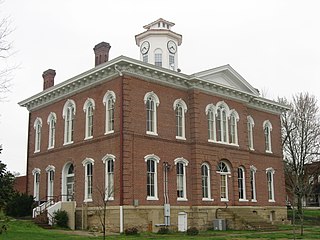
Harrisburg is a city in and the county seat of Saline County, Illinois, United States. It is located about 57 miles southwest of Evansville, Indiana, and 111 mi (179 km) southeast of St. Louis, Missouri. The 2020 population was 8,219, and the surrounding Harrisburg Township had a population of 10,037, including the city residents. Harrisburg is included in the Illinois–Indiana–Kentucky tri-state area and is the principal city in the Harrisburg Micropolitan Statistical Area with a combined population of 24,913.

Muddy is a small incorporated village located in the Harrisburg Township in Saline County, Illinois, United States. The population was 78 at the 2000 census.

Stonefort is a village in Saline and Williamson Counties, Illinois, United States. The population was 297 at the 2010 census.

Southern Illinois, also known as Little Egypt, is the southern third of Illinois, principally along and south of Interstate 64. Although part of a Midwestern state, this region is aligned in culture more with that of the Upland South than the Midwest. Part of downstate Illinois, it is bordered by the two most voluminous rivers in the United States: the Mississippi below its connecting Missouri River to the west and the Ohio River to the east and south with the Wabash as tributary.

The Cache River is a 92-mile-long (148 km) waterway in southernmost Illinois, in a region sometimes called Little Egypt. The basin spans 737 square miles (1,910 km2) and six counties: Alexander, Johnson, Massac, Pope, Pulaski and Union. Located at the convergence of four major physiographic regions, the river is part of the largest complex of wetlands in Illinois. The Cache River Wetlands — America's northernmost cypress/tupelo swamp — harbors 91 percent of the state's high quality swamp and wetland communities. It provides habitat for more than 100 threatened and endangered species in Illinois. In 1996, the Cache was designated a Wetland of International Importance by the Ramsar Convention.

The Saline River is a tributary of the Ohio River, approximately 27 miles (43 km) long, in the Southern Illinois region of the U.S. state of Illinois. The river drains a large section of southeast Illinois, with a drainage basin of 1,762 square miles (4,564 km2). The major tributaries include the South Fork, Middle Fork and North Fork, all lying within the Saline Valley. The once meandering swampy river was important among Native Americans and early settlers as a source of salt from numerous salt springs where it was commercially extracted in the early 19th century.

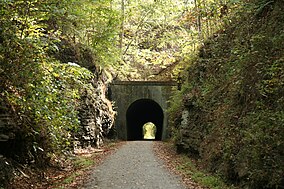
The Kororoit Creek Trail is a shared use path for cyclists and pedestrians, which follows the Kororoit Creek in the inner western suburbs of Melbourne, Victoria, Australia.
The Cairo and Vincennes Railroad was a 19th-century American railroad that connected Cairo, Illinois, with Vincennes, Indiana. It was chartered by the state of Illinois in 1867 through the efforts of former American Civil War General Green B. Raum, who subsequently oversaw the planning and engineering of the proposed line. Within a few years, the fledgling railroad company named another former general, Ambrose Burnside, as its president. The Cairo & Vincennes began laying track in 1870 and completed the initial portion in 1872 to haul coal from southern Illinois mines. However, the route was not fully completed until late in 1874.

Brandon Phelps is a Democratic member of the Illinois House of Representatives, representing the 118th District from January 2003 to September 2017. The 118th district, located in Southern Illinois, includes all or parts of Anna, Belknap, Belle Prairie City, Brookport, Broughton, Buncombe, Burnside, Cairo, Carbondale, Carrier Mills, Cave-In-Rock, Cypress, Dahlgren, Dongola, East Cape Girardeau, Eddyville, Eldorado, Elizabethtown, Equality, Galatia, Golconda, Goreville, Harrisburg, Joppa, Junction, Karnak, Makanda, Marion, McClure, McLeansboro, Metropolis, Mound City, Mounds, New Grand Chain, New Haven, Old Shawneetown, Olive Branch, Olmsted, Omaha, Pulaski, Raleigh, Ridgway, Rosiclare, Shawneetown, Simpson, Stonefort, Tamms, Thebes, Ullin, and Vienna. He resigned on September 1, 2017.
Natalie Phelps Finnie was a Democratic member of the Illinois House of Representatives, representing the 118th District from September 2017 to January 2019. The 118th district, located in Southern Illinois, includes all or parts of Anna, Belknap, Belle Prairie City, Brookport, Broughton, Buncombe, Burnside, Cairo, Carbondale, Carrier Mills, Cave-In-Rock, Cypress, Dahlgren, Dongola, East Cape Girardeau, Eddyville, Eldorado, Elizabethtown, Equality, Galatia, Golconda, Goreville, Harrisburg, Joppa, Junction, Karnak, Makanda, Marion, McClure, McLeansboro, Metropolis, Mound City, Mounds, New Grand Chain, New Haven, Old Shawneetown, Olive Branch, Olmsted, Omaha, Pulaski, Raleigh, Ridgway, Rosiclare, Shawneetown, Simpson, Stonefort, Tamms, Thebes, Ullin, and Vienna.
Patrick Windhorst is an American politician from Illinois. Windhorst is a Republican member of the Illinois House of Representatives for the 118th district. The 118th district, located in Southern Illinois, includes all or parts of Anna, Belknap, Belle Prairie City, Brookport, Broughton, Buncombe, Burnside, Cairo, Carbondale, Carrier Mills, Cave-In-Rock, Cypress, Dahlgren, Dongola, East Cape Girardeau, Eddyville, Eldorado, Elizabethtown, Equality, Galatia, Golconda, Goreville, Harrisburg, Joppa, Junction, Karnak, Makanda, Marion, McClure, McLeansboro, Metropolis, Mound City, Mounds, New Grand Chain, New Haven, Old Shawneetown, Olive Branch, Olmsted, Omaha, Pulaski, Raleigh, Ridgway, Rosiclare, Shawneetown, Simpson, Stonefort, Tamms, Thebes, Ullin, and Vienna. Windhorst lives in Metropolis, Illinois.