Tuscarawas County is a county located in the northeastern part of the U.S. state of Ohio. As of the 2020 census, the population was 93,263. Its county seat is New Philadelphia. Its name is a Delaware Indian word variously translated as "old town" or "open mouth". Tuscarawas County comprises the New Philadelphia–Dover, OH Micropolitan Statistical Area, which is also included in the Cleveland–Akron–Canton, OH Combined Statistical Area.

Winesburg is an unincorporated community and census-designated place (CDP) in Paint Township, Holmes County, Ohio, in the United States. The population was 340 at the 2020 census. The community sits on the crest of a hill in the Amish country of Ohio. It lies along U.S. Route 62.

Homeworth is an unincorporated community and census-designated place in southwestern Knox Township, Columbiana County, Ohio, United States. The population was 492 as of the 2020 census. It is part of the Salem micropolitan area, about 16.5 miles (26.6 km) east of Canton, and has a post office with the ZIP code 44634.

Sugar Creek Township is one of the sixteen townships of Wayne County, Ohio, United States. The 2020 census found 7,187 people in the township.
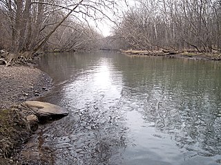
Sandy Creek is a tributary of the Tuscarawas River, 41.3 miles (66.5 km) long, in northeastern Ohio. Via the Tuscarawas, Muskingum and Ohio Rivers, it is part of the watershed of the Mississippi River, draining an area of 503 square miles (1,303 km²).
Pike Township is one of the seventeen townships of Stark County, Ohio, United States. The 2020 census found 3,818 people in the township, 3,069 of whom lived in the unincorporated portions of the township.

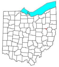
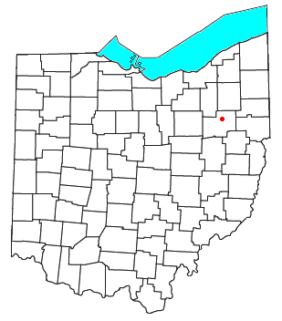
Sandy Township is one of the twenty-two townships of Tuscarawas County, Ohio, United States. The 2020 census found 2,946 people in the township.

Bethlehem Township is one of the seventeen townships of Stark County, Ohio, United States. The 2020 census found 5,520 people in the township.
Brown Township is one of the fourteen townships of Carroll County, Ohio, United States. As of the 2020 census the township had a population of 7,214.

Tippecanoe is an unincorporated community and census-designated place (CDP) in central Washington Township, Harrison County, Ohio, United States. It is located along State Route 800 in the valley of Stillwater Creek, a north-flowing tributary of the Tuscarawas River. It had a post office until 2011 with the ZIP code 44699. The population was 83 at the 2020 census.

East Rochester is an unincorporated community and census-designated place (CDP) in southern West Township, Columbiana County, Ohio, United States. The population was 224 as of the 2020 census. It lies along U.S. Route 30, and has a post office with the ZIP code 44625. It is a part of the Salem micropolitan area, about 20 miles (32 km) east of Canton.

Stewart is an unincorporated community and census-designated place in central Rome Township, Athens County, Ohio, United States. The population was 221 at the 2020 census. It has a post office with the ZIP code 45778.

Dundee is a census-designated place in central Wayne Township, Tuscarawas County, Ohio, United States. It has a post office with the ZIP code 44624. It lies at the intersection of State Routes 93 and 516. The population was 269 at the 2020 census.

Somerdale is an unincorporated community in northeastern Fairfield Township, Tuscarawas County, Ohio, United States. It has a post office with the ZIP code 44678. It lies along State Route 212, Conotton Creek and the Wheeling and Lake Erie Railway east of Zoar.

North Lawrence is a census-designated place in southwestern Lawrence Township, Stark County, Ohio, United States. It has a post office with the ZIP code 44666. The community is part of the Canton–Massillon Metropolitan Statistical Area. The population was 212 at the 2020 census.
Middlebranch is a census-designated place in northeastern Plain Township, Stark County, Ohio, United States. It is located about 7 miles Northeast of Canton. It has a post office with the ZIP code 44652. The community is part of the Canton–Massillon Metropolitan Statistical Area. The population was 2,117 at the 2020 census. Trains from the Wheeling and Lake Erie Railway often run through the area carrying loads of scrap metal bound for other Ohio cities.
Robertsville is an unincorporated community and census-designated place in western Paris Township, Stark County, Ohio, United States. It has a post office with the ZIP code 44670. It lies along U.S. Route 30 between East Canton and Minerva and is in the Minerva Local School District. The community is part of the Canton–Massillon Metropolitan Statistical Area. The population was 293 at the 2020 census.

New Cumberland is an unincorporated community in Warren Township, Tuscarawas County, Ohio, United States. The community is served by the Mineral City, Ohio post office, ZIP code 44656. It is located on Conotton Creek, State Route 212 and the Wheeling and Lake Erie Railway.

Ravenswood District, formerly Ravenswood Magisterial District, is one of five historic magisterial districts in Jackson County, West Virginia, United States. The district was originally known as Gilmore Township, one of five civil townships established in 1863; the name officially became "Ravenswood" in 1871, and Jackson County's townships were converted into magisterial districts in 1872. When Jackson County was redistricted in the 1990s, the area of Ravenswood District was divided between the new Northern and Western Magisterial Districts. However, the county's historic magisterial districts continue to exist in the form of tax districts, serving all of their former administrative functions except for the election of county officials.

The Northern Magisterial District is one of three magisterial districts in Jackson County, West Virginia, United States. It was established during a process of redistricting undertaken in the 1990s. In 2010, 8,753 people lived in the district.