
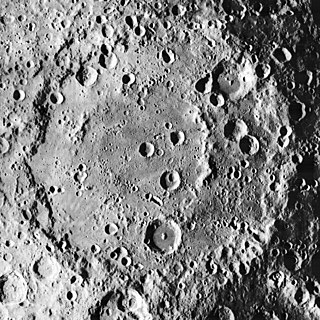
An impact crater is a circular depression in the surface of a solid astronomical object formed by the hypervelocity impact of a smaller object. In contrast to volcanic craters, which result from explosion or internal collapse, impact craters typically have raised rims and floors that are lower in elevation than the surrounding terrain. Lunar impact craters range from microscopic craters on lunar rocks returned by the Apollo program and small, simple, bowl-shaped depressions in the lunar regolith to large, complex, multi-ringed impact basins. Meteor Crater is a well-known example of a small impact crater on Earth.

Adams County is a county in the U.S. state of Ohio. As of the 2020 census, the population was 27,477. Its county seat and largest village is West Union. The county is named after John Adams, the second President of the United States.

Volcanic cones are among the simplest volcanic landforms. They are built by ejecta from a volcanic vent, piling up around the vent in the shape of a cone with a central crater. Volcanic cones are of different types, depending upon the nature and size of the fragments ejected during the eruption. Types of volcanic cones include stratocones, spatter cones, tuff cones, and cinder cones.

Manicouagan Reservoir is an annular lake in central Quebec, Canada, covering an area of 1,942 km2 (750 sq mi). The lake island in its centre is known as René-Levasseur Island, and its highest point is Mount Babel. The structure was created 214 (±1) million years ago, in the Late Triassic, by the impact of a meteorite 5 km (3 mi) in diameter. The lake and island are clearly seen from space and are sometimes called the "eye of Quebec". The lake has a volume of 137.9 km3 (33.1 cu mi).

The Kentland structure, also known as the Kentland crater or the Kentland disturbed area, is an impact structure located near the town of Kentland in Newton County, Indiana, United States.
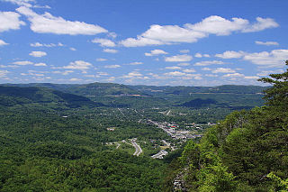
The Middlesboro crater is a meteorite crater in Kentucky, United States. It is named after the city of Middlesborough, which today occupies much of the crater.

The Popigai impact structure is the eroded remnant of an impact crater in northern Siberia, Russia. It is tied with the Manicouagan structure as the fourth largest verified impact structure on Earth. A large bolide impact created the 100-kilometre (62 mi) diameter crater approximately 35 million years ago during the late Eocene epoch. It might be linked to the Eocene–Oligocene extinction event.

Puchezh-Katunki is a meteor crater located in the Nizhny Novgorod Oblast of the Volga Federal District, Russia. It is 80 km (50 mi) in diameter. Argon–argon dating has constrained the age of formation to be 195.9 ± 1.0 million years old, placing it within the Sinemurian stage of the Early Jurassic. The crater is not exposed to the surface, but appears as variation in the vegetation. The Earth Impact Database lists a rim-to-rim diameter of 40 kilometres (25 mi).

Shoemaker is an impact structure, the deeply eroded remnant of a former impact crater, situated in arid central Western Australia, about 100 km (62 mi) north-northeast of Wiluna. It is named in honour of planetary geologist Eugene Shoemaker.

Upheaval Dome is an enigmatic geological structure in San Juan County, Utah, United States, that has been variously interpreted as a meteorite impact structure or a salt dome. The structure lies 22 miles (35 km) southwest of the city of Moab, Utah, in the Island in the Sky section of Canyonlands National Park.

The Vredefort impact structure is the largest verified impact structure on Earth. The crater, which has since been eroded away, has been estimated at 170–300 kilometres (110–190 mi) across when it was formed. The remaining structure, comprising the deformed underlying bedrock, is located in present-day Free State province of South Africa. It is named after the town of Vredefort, which is near its centre. The structure's central uplift is known as the Vredefort Dome. The impact structure was formed during the Paleoproterozoic Era, 2,023 million years ago. It is the second-oldest known impact structure on Earth, after Yarrabubba.

The Great Serpent Mound is a 1,348-feet-long (411 m), three-feet-high prehistoric effigy mound located in Peebles, Ohio. It was built on what is known as the Serpent Mound crater plateau, running along the Ohio Brush Creek in Adams County, Ohio. The mound is the largest serpent effigy known in the world.

Antoniadi is a large lunar impact crater that lies on the southern hemisphere on the far side of the Moon. The crater intrudes into the southeastern rim of the crater Minnaert, a slightly smaller formation that is significantly more eroded. Attached to the eastern rim of Antoniadi is Numerov, another large, ancient crater similar to Minnaert. Due south of Antoniadi is the small crater Brashear.
Korolev is a large lunar impact crater of the walled plain or basin type. It is a basin of Nectarian age.

Mead is an impact crater on Venus named in honor of the cultural anthropologist Margaret Mead.
Ohio Brush Creek is a 59.9-mile-long (96.4 km) tributary of the Ohio River in southern Ohio in the United States. Via the Ohio River, it is part of the watershed of the Mississippi River, draining an area of 435 square miles (1,130 km2). According to the Geographic Names Information System, it has also been known historically as "Brush Creek," "Elk Creek," and "Little Scioto River".

Bratton Township is one of the fifteen townships of Adams County, Ohio, United States. The population was 1,380 at the 2020 census.
Highlands Sanctuary, Inc. is a nonprofit organization which operates under the dba of The Arc of Appalachia Preserve System. The Arc of Appalachia has been in operation since 1995, working to create and steward nature preserves in the forested Appalachian counties of southern Ohio. In 2016, The Arc of Appalachia had completed the protection of 4268 acres in 15 preserve regions.

The Charity Shoal crater is a 1.2–1.4 kilometers (0.75–0.87 mi) in diameter circular feature that lies submerged beneath the northeast end of Lake Ontario about 12 kilometers (7.5 mi) southwest of Wolfe Island, and 25 kilometers (16 mi) south of Kingston, Ontario at about latitude 44° 02′ N and longitude 76° 29′ W. It is hypothesized to be a Middle Ordovician impact crater.


