Sha Tin District is one of the 18 districts of Hong Kong. As one of the 9 districts located in the New Territories, it covers the areas of Sha Tin, Tai Wai, Ma On Shan, Fo Tan, Siu Lek Yuen, Kwun Yam Shan and Ma Liu Shui. The district is the most populous district in Hong Kong, with a population of 659,794 as per 2016 by-census, having a larger population than many states or dependencies including Iceland, Malta, Montenegro and Brunei.

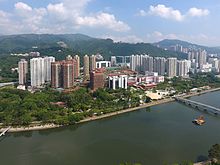
The Shing Mun River or Shing Mun River Channel is a river in Sha Tin, Hong Kong.
Hong Kong counts approximately 600 temples, shrines and monasteries. While Buddhism and Christianity are the most widely practiced religions, most religions are represented in the Special Administrative Region.

Tai Wai is an area in the New Territories, Hong Kong, located between Sha Tin and the Lion Rock, within the Sha Tin District.

Route 9, Hong Kong is one of the strategic trunk roads, mostly in the form of a motorway, circumnavigating the New Territories. The route is also known as the New Territories Circular Road (新界環迴公路). Starting from the Shing Mun Tunnels, Route 9 links Sha Tin, Tai Po, Fanling, Sheung Shui, Yuen Long, Tuen Mun and Tsuen Wan. The section between Exit 10 in Kwu Tung and Exit 16 in Lam Tei is part of Asian Highway 1, although the Asian Highway Network is not signed in Hong Kong.
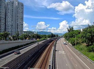
Tate's Cairn Highway, opened on 26 June 1991, is a dual 3-lane expressway in Hong Kong. It links Tate's Cairn Tunnel and Ma Liu Shui Interchange, forming a part of Route 2.
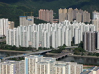
City One Shatin is a residential precinct in Sha Tin, New Territories, Hong Kong. The estate occupies approximately 1,800,000 square feet of land. The estate was named City One as it is on Lot 1, Shatin Town. It has a census area population of 24,758 people. City One is the largest private residential estate in Sha Tin District. There are a total of 52 blocks of residential buildings with 10,642 units. Each tower is about 30 storeys with units ranging from 389 square feet (36.1 m2) to an area of 1,018 square feet (94.6 m2), offering different floor plans.

Sha Tin, also spelt Shatin, is a neighbourhood along Shing Mun River in the eastern New Territories, Hong Kong. Administratively, it is part of the Sha Tin District. Sha Tin is one of the neighbourhoods of the Sha Tin New Town project.
East Kowloon line was one of the original five MTR lines proposed in the late 1970s in Hong Kong, which would have connected Sheung Wan with East Kowloon.

Tai Po New Town, or Tai Po Town, is a new town and non-administrative area in Tai Po District, in the New Territories, Hong Kong. The area is a planned town that surrounding the existing indigenous market towns Tai Po Hui and Tai Po Kau Hui, as well as east of the existing indigenous villages that located on the Lam Tsuen Valley as well as west of those villages in Ting Kok and Tai Mei Tuk and south of those villages in Nam Hang, Fung Yuen and Sha Lo Tung. Most of the lands of the new town were obtained by land reclamation. In present day, Tai Po New Town was simply known as Tai Po. The new town are largely covered by the government Tai Po Outline Zoning Plan, which legally regulated the land use of the area, on top of the terms in the land lease contract with the government. Some of the land lease within the area, were known as Tai Po Town Lot № foo. In election, the town had a different zoning scheme for the election constituencies.

The Hong Kong Strategic Route and Exit Number System is a system adopted by the Transport Department of the Hong Kong Government to organise the major roads in the territory into routes 1 to 10 for the convenience of drivers. When the system was implemented in 2004, the government promoted it with a major public campaign, including the slogan "Remember the Numbers; Make Driving Easier".

Ma On Shan Road is a major road in the new town of Ma On Shan in the New Territories of Hong Kong. The road extends northward from Tate's Cairn Highway near Tai Shui Hang along the eastern bank of the Shing Mun River. It ends in the north when it joins Sai Sha Road near Wu Kai Sha. Its branch road, the Ma On Shan Bypass, redirects traffic between Sha Tin and Sai Kung North away from the town centre near the Heng On Estate. It is the primary thoroughfare to Ma On Shan. A short section of the road north of Tate's Cairn Highway is an expressway.
Articles related to Hong Kong include:

Pak Shek Kok is a place in Tai Po District in Hong Kong, located between Ma Liu Shui and Tai Po Kau, close to Cheung Shue Tan (樟樹灘) and facing Tolo Harbour. The Kowloon–Canton Railway, Tolo Highway, Hong Kong Science Park are all situated on the reclamation outside Pak Shek Kok.
The following is a non-exhaustive list of private housing estates in Sha Tin District, Hong Kong.

The Hong Kong government started developing new towns in the 1950s to accommodate Hong Kong's booming population. During the first phase of development, the newly developed towns were called "satellite towns", a concept borrowed from the United Kingdom, of which Hong Kong was a colony. Kwun Tong, located in eastern Kowloon, and Tsuen Wan, located in the south-west of the New Territories, were designated as the first satellite towns, when the urban area in Hong Kong was still relatively small, restricted to the central and western parts of Kowloon Peninsula and the northern side of Hong Kong Island. Wah Fu Estate was also built in a remote corner on the southern side of Hong Kong Island, with similar concepts but at a smaller scale.