The new town was founded in 1973 under the New Towns Development Programme of the Hong Kong government. Its current name was named after the nearby village of Sha Tin Wai. The literal English translation is 'Sand Fields'.
Before British rule in Hong Kong, the area of Sha Tin and its vicinity was referred to as Lek Yuen (lit. "source of trickling" or "source of clear water"). Colonial officials allegedly mistook[citation needed] the name of the Sha Tin Wai village as the name of the area and it has been used ever since. Nowadays, the original name is used to refer to Lek Yuen Estate.
Sha Tin was the location of the first flight of a powered aircraft in Hong Kong in 1911. The aeroplane was named as the Spirit of Sha Tin (沙田精神號). A full size replica of this plane now hangs in Hong Kong International Airport.
The area was formerly agricultural farmland. Before Sha Tin's development into a new town, Hung Mui Kuk (紅梅谷), southwest of Sha Tin, was perennially the main site for school picnics. The hillside area remains a popular barbecue site.
Starting in the 1970s, the area became part of the Sha Tin New Town development. Since then, the economy in the area has greatly improved and living standards have also increased. Sha Tin Town Centre was developed during the mid-1980s to help "link the town's currently dispersed residents into one cohesive community."[1] The 18-hectare site, adjacent to the railway station, was built up in stages to house an array of uses including the New Town Plaza, numerous smaller shopping malls, Sha Tin Park, a magistracy, library, town hall, marriage registry, hotel, town square, and several residential towers.
Sha Tin is located in a valley, on both sides of the Shing Mun River, running from the southwest to the northeast. It is bordered by Tai Wai in the southwest and by Fo Tan (left bank) and Shek Mun (right bank) in the northeast.
Cross-border activities
Due to their proximity to the Shenzhen border, towns in the northern parts of Hong Kong, notably Sheung Shui and Yuen Long, have become hubs for parallel traders who have been buying up large quantities of goods, forcing up local prices and disrupting the daily lives of local citizens.[2][3] Since 2012, there has been an increase in mainland parallel traders arriving in the North District of Hong Kong to re-export infant formula and household products – goods popular with mainlanders – across the border to Shenzhen.[4] The volume of smuggling activity spilled over into Tuen Mun and Sha Tin in 2014.
The first anti-parallel trading protest was started at Sheung Shui in September 2012.[5] As government efforts to limit the adverse impact of mainland trafficking were widely seen as inadequate, so there have been further subsequent protests in towns in the New Territories including Sha Tin.[6][7]
Housing
Sand Martin House of Sha Kok Estate, a second phase public housing complex in Sha Tin Wai.Sha Tin Plaza in the evening.
Lukfook, the jewellery company, has its head office in Metropole Square (新都廣場), Sha Tin.[9]
Architecture
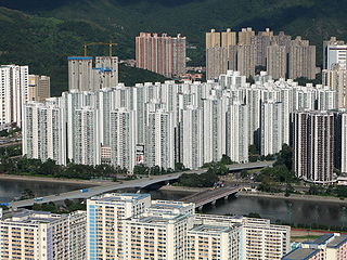
While having been mass developed in the 1970s, Shatin's architecture maintains a degree of diversity. Most public housing estates were designed in a modern architectural style. Several shopping centres, hotels and government buildings around Shatin Central are clad in red brick.
The Prince of Wales Hospital was officially opened in 1982. It provides about 1,400 hospital beds and 24 hours Accident & Emergency service to the eastern New Territories. Other institutions which provide hospital services include the Sha Tin Hospital, the Cheshire Home and the Union Hospital.
As of 2008, there were 46 primary and 44 secondary schools in Sha Tin and Ma On Shan.[12]
Shatin Town Centre is in Primary One Admission (POA) School Net 91. Within the school net are multiple aided schools (operated independently but funded with government money); no government schools are in this net.[13]
There are numerous cultural, recreational and sport facilities in Sha Tin including the Town Hall, swimming pools, football pitches, indoor recreation centres and various track and field facilities for the use of Sha Tin residents.
The 8-hectare Sha Tin Park was opened to public in 1988. Apart from its horticultural gardens and impressive water features, it also includes a large open plaza and a bandstand. The Ma On Shan Park, which is adjacent to Ma On Shan Swimming Pool, occupies 5.5 hectare of land.
The Sha Tin Racecourse, occupying approximately 70 hectares, rests on reclaimed flatland. At the centre of the racecourse is the Penfold Garden which opens to the public on non-racing days.
Located in Tai Wai, the Hong Kong Heritage Museum was opened at the end of 2000. Apart from introducing the art, culture and history of the New Territories, the museum also exhibits a variety of cultural artifacts for public appreciation. It has pop culture exhibitions about Bruce Lee, Cantonese Opera, Jin Yong, development of Hong Kong popular music, film, and television and radio programmes. The museum, which can accommodate 6,000 visitors, is the largest in the territory.
Cycling has been a distinctive feature in Sha Tin and is very popular among both local people and visitors. The first cycle track in Sha Tin was opened to public in 1981, running along Tolo Highway to Tai Po, and this remains the territory's most popular cycling venue, drawing many occasional riders at the weekends, as well as dedicated cyclists. To tie in with the development of Ma On Shan, the cycle track was extended to Ma On Shan.
Hiking is also a popular activity around Sha Tin. There are several starting points including Hin Tin Village, Sha Tin Tau Village and Hung Mui Kuk Barbecue Area leading to the track of Lion Rock Mountain hiking route. It takes 1 hour to 4 hours to complete the track depending on the chosen starting point and ending point.
Sha Tin is famous for certain local variants of Cantonesefood such as ShanSui Tofu (山水豆腐; 'mountain-water beancurd'), barbecued pigeon and chicken congee. The cooked food stalls in Wo Che Estate and Fo Tan are hotspots for food.
There are numerous transportation links both within the Sha Tin District and connecting it to other places in Hong Kong.
Roads
The road network in Sha Tin is well developed to provide efficient cross-town and local access traffic. Connection between Sha Tin and Kowloon mainly relies on the Lion Rock Tunnel, Tate's Cairn Tunnel, Shing Mun Tunnel and Tai Po Road which makes it easy to reach from many areas of Kowloon as well as from Tsuen Wan.
Tai Po Road spans from Sham Shui Po in Kowloon to Tai Po in the New Territories, connecting Sha Tin en route. It was once the only road connecting Kowloon and the eastern part of the New Territories.
Opened in the 1960s, the Lion Rock Tunnel offers access to Central Kowloon.
Sai Sha Road was opened in 1988, connecting Sha Tin to Sai Kung via Ma On Shan. Route T7, opened in August 2004, allows traffic to bypass Ma On Shan Town Centre when going from north of Ma On Shan to Sai Kung.
An expressway (via Eagle's Nest Tunnel) connecting Cheung Sha Wan in Kowloon to Sha Tin was opened on 21 March 2008. It aims at distributing traffic from Sha Tin and the area to its north, to Lai Chi Kok, Kwai Chung, and the airport at Chek Lap Kok and Mong Kok. It has shortened the trip from Sha Tin to the Chek Lap Kok International Airport to around 40 minutes.
At present, there are over 110 routes of public bus serving Sha Tin.[citation needed]
Railway
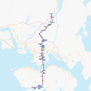
The MTR (East Rail line) is a major means of transportation between Admiralty and Lo Wu via Sha Tin. After the electrification of the line between 1979 and 1983, the East Rail now carries over 730,000 passengers daily.
The Tuen Ma line opened on 21 December 2004. The 56.4km long railway has 27 stations linking West Rail line at Hung Hom via Kai Tak. The MTR Maintenance Centre is located in Tai Wai.
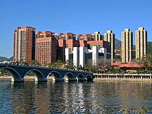
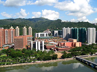
Shatin's cityscape viewed from northern Fo Tan
A panorama of Sha Tin City taken from Sha Tin Lion Pavilion
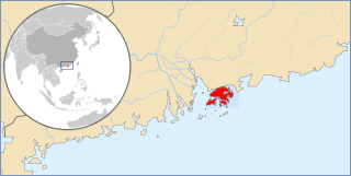
Sha Tin District is one of the 18 districts of Hong Kong. As one of the 9 districts located in the New Territories, it covers the areas of Sha Tin, Tai Wai, Ma On Shan, Fo Tan, Siu Lek Yuen, Kwun Yam Shan and Ma Liu Shui. The district is the most populous district in Hong Kong, with a population of 659,794 as per 2016 by-census, having a larger population than many states or dependencies including Iceland, Malta, Montenegro and Brunei.
Hong Kong counts approximately 600 temples, shrines and monasteries. While Buddhism and Christianity are the most widely practiced religions, most religions are represented in the Special Administrative Region.
Tai Wai is an area in the New Territories, Hong Kong, located between Sha Tin and the Lion Rock, within the Sha Tin District.
Sha Tin Wai is a station on the Tuen Ma line in Sha Tin, Hong Kong. The name "Sha Tin Wai" comes from the village called Sha Tin Wai, which is located to the northeast of the station. It was provisionally called "Sha Kok Street" before the Ma On Shan line opened, because it is located at Sha Kok Street.
Sheung Shui is an area in the New Territories, Hong Kong. Sheung Shui Town, a part of this area, is part of the Fanling–Sheung Shui New Town in the North District of Hong Kong. Fanling Town is to its southeast.
Telephone numbers in Hong Kong are mostly eight-digit. Fixed land line numbers start with 2 or 3, mobile (cellular) phone numbers with 5, 6, 7 or 9, pager numbers with 7 and forwarding service with 8. Since the end of 1989, there have been no area codes within Hong Kong.
City One Shatin is a residential precinct in Sha Tin, New Territories, Hong Kong. The estate occupies approximately 1,800,000 square feet of land. The estate was named City One as it is on Lot 1, Shatin Town. It has a census area population of 24,758 people. City One is the largest private residential estate in Sha Tin District. There are a total of 52 blocks of residential buildings with 10,642 units. Each tower is about 30 storeys with units ranging from 389 square feet (36.1 m2) to an area of 1,018 square feet (94.6 m2), offering different floor plans.
Route 1 is a major artery in Hong Kong that runs in a generally north-south direction, connecting Aberdeen with Sha Tin.
Sha Tin New Town, or known as Sha Tin-Ma On Shan New Town or Sha Tin Town is one of the satellite towns and new towns of Hong Kong. It is within the Sha Tin District, the New Territories. The New Town covers the neighbourhoods such as Sha Tin, Tai Wai, Fo Tan, Tai Shui Hang, Ma On Shan. The Shing Mun River runs through the middle of the town.
Siu Lek Yuen is an area in Sha Tin District, New Territories East. Located to the east of Yuen Chau Kok, the area is surrounded on three sides by the Ma On Shan Country Park. Nowadays it is a residential area.
Articles related to Hong Kong include:
The following is a non-exhaustive list of private housing estates in Sha Tin District, Hong Kong.
The following is a list of public housing estates in Sha Tin, Hong Kong, including Home Ownership Scheme (HOS), Private Sector Participation Scheme (PSPS), Sandwich Class Housing Scheme (SCHS), Flat-for-Sale Scheme (FFSS), and Tenants Purchase Scheme (TPS) estates.
The Hong Kong government started developing new towns in the 1950s to accommodate Hong Kong's booming population. During the first phase of development, the newly developed towns were called "satellite towns", a concept borrowed from the United Kingdom, of which Hong Kong was a colony. Kwun Tong, located in eastern Kowloon, and Tsuen Wan, located in the south-west of the New Territories, were designated as the first satellite towns, when the urban area in Hong Kong was still relatively small, restricted to the central and western parts of Kowloon Peninsula and the northern side of Hong Kong Island. Wah Fu Estate was also built in a remote corner on the southern side of Hong Kong Island, with similar concepts but at a smaller scale.
↑ "Corporate Information". Lukfook. Retrieved 28 November 2023. HEAD OFFICE AND PRINCIPAL PLACE OF BUSINESS 15th, 20th, 25th & 27th Floor Metropole Square No.2 On Yiu Street, Shatin New Territories, Hong Kong - Traditional Chinese address: "香港新界沙田安耀街2號新都廣場15、20、25及27樓", Simplified Chinese address: "香港新界沙田安耀街2号新都广场15、20、25及27楼"
This page is based on this Wikipedia article Text is available under the CC BY-SA 4.0 license; additional terms may apply. Images, videos and audio are available under their respective licenses.