Related Research Articles
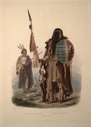
The Assiniboine or Assiniboin people, also known as the Hohe and known by the endonym Nakota, are a First Nations/Native American people originally from the Northern Great Plains of North America.
Treaty 7 is an agreement between the Crown and several, mainly Blackfoot, First Nation band governments in what is today the southern portion of Alberta. The idea of developing treaties for Blackfoot lands was brought to Blackfoot chief Crowfoot by John McDougall in 1875. It was concluded on September 22, 1877, and December 4, 1877. The agreement was signed at the Blackfoot Crossing of the Bow River, at the present-day Siksika Nation reserve, approximately 75 km (47 mi) east of Calgary, Alberta. Chief Crowfoot was one of the signatories to Treaty 7. Another signing on this treaty occurred on December 4, 1877, to accommodate some Blackfoot leaders who were not present at the primary September 1877 signing.
First Nations in Alberta are a group of people who live in the Canadian province of Alberta. The First Nations are peoples recognized as Indigenous peoples or Plains Indians in Canada excluding the Inuit and the Métis. According to the 2011 Census, a population of 116,670 Albertans self-identified as First Nations. Specifically there were 96,730 First Nations people with registered Indian Status and 19,945 First Nations people without registered Indian Status. Alberta has the third largest First Nations population among the provinces and territories. From this total population, 47.3% of the population lives on an Indian reserve and the other 52.7% live in urban centres. According to the 2011 Census, the First Nations population in Edmonton totalled at 31,780, which is the second highest for any city in Canada. The First Nations population in Calgary, in reference to the 2011 Census, totalled at 17,040. There are 48 First Nations or "bands" in Alberta, belonging to nine different ethnic groups or "tribes" based on their ancestral languages.
Treaty 6 is the sixth of the numbered treaties that were signed by the Canadian Crown and various First Nations between 1871 and 1877. It is one of a total of 11 numbered treaties signed between the Canadian Crown and First Nations. Specifically, Treaty 6 is an agreement between the Crown and the Plains and Woods Cree, Assiniboine, and other band governments at Fort Carlton and Fort Pitt. Key figures, representing the Crown, involved in the negotiations were Alexander Morris, Lieutenant Governor of Manitoba and The North-West Territories; James McKay, The Minister of Agriculture for Manitoba; and William J. Christie, a chief factor of the Hudson's Bay Company. Chief Mistawasis and Chief Ahtahkakoop represented the Carlton Cree.
The Enoch Cree Nation #440 is a First Nations band government in Alberta, Canada. Members of the Nation are of Cree ancestry and speak the Plains Cree dialect of the Cree language group. The band is a signatory of Treaty 6 and is a member of the Confederacy of Treaty Six First Nations. The chief of the Enoch Cree Nation is Cody Thomas.
The Nakoda are an Indigenous people in Western Canada and the United States.
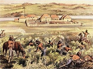
Fort Pitt Provincial Park is a provincial park in the Canadian province of Saskatchewan. Fort Pitt was built in 1829 by the Hudson's Bay Company (HBC) and was a trading post on the North Saskatchewan River in Rupert's Land. It was built at the direction of Chief Factor John Rowand, previously of Fort Edmonton, to trade for bison hides, meat and pemmican. Pemmican, dried buffalo meat, was required as provisions for HBC's northern trading posts.

Maskwacis, renamed in 2014 from Hobbema, is an unincorporated community in central Alberta, Canada at intersection of Highway 2A and Highway 611, approximately 70 kilometres (43 mi) south of the City of Edmonton. The community consists of two Cree First Nations communities – one on the Ermineskin 138 reserve to the north and the other on the Samson 137 reserve to the south. It also consists of an adjacent hamlet within Ponoka County. The community also serves three more nearby First Nations reserves including Samson 137A to the south, Louis Bull 138B to the northwest, and Montana 139 to the south.
The Alexis Nakota Sioux Nation no. 437 is a Nakoda First Nation which reserves near Edmonton, Hinton, and Whitecourt, in the Canadian province of Alberta, and headquartered at 54° N and 114°, about 85 kilometres (53 mi) west of Edmonton. The Alexis Nakota Sioux Nation is a member of Treaty 6.
The Paul First Nation, more commonly known as the Paul Band, is a First Nations band government based in Wabamun, Alberta of mixed Cree and Nakoda (Stoney) origin. They are party to Treaty Six and had the Buck Lake Indian Reserve 133C and Wabamun Lake Indian Reserve 133A, 133B and 133C allocated to them by the federal government in 1892. However, the Buck Lake Reserve was decimated by the Spanish Flu of 1918 and is now largely abandoned.
The Papaschase are a group of Cree people descended from Chief Papaschase's Band of the 19th century, who were a party to Treaty 6 with Canada. A modern-day group of Papaschase descendants are working to advance their treaty rights and reclaim their reserve's land or get compensation for its loss. They claim the reserve was surrendered unlawfully in 1888, but they have not been recognized yet by the Canadian Government Alexander First Nation #134 #134a #134b #143

The Beaver Lake Cree Nation is a First Nations band government located 105 kilometres (65 mi) northeast of Edmonton, Alberta, representing people of the Cree ethno-linguistic group in the area around Lac La Biche, Alberta, where the band office is currently located. Their treaty area is Treaty 6. The Intergovernmental Affairs office consults with persons on the Government treaty contacts list. There are two parcels of land reserved for the band by the Canadian Crown, Beaver Lake Indian Reserve No. 131 and Blue Quills First Nation Indian Reserve. The latter reserve is shared by six bands; Beaver Lake Cree Nations, Cold Lake First Nations, Frog Lake First Nation, Heart Lake First Nation, Kehewin Cree Nation, Saddle Lake Cree Nation.
The Iron Confederacy or Iron Confederation was a political and military alliance of Plains Indians of what is now Western Canada and the northern United States. This confederacy included various individual bands that formed political, hunting and military alliances in defense against common enemies. The ethnic groups that made up the Confederacy were the branches of the Cree that moved onto the Great Plains around 1740, the Saulteaux, the Nakoda or Stoney people also called Pwat or Assiniboine, and the Métis and Haudenosaunee. The Confederacy rose to predominance on the northern Plains during the height of the North American fur trade when they operated as middlemen controlling the flow of European goods, particularly guns and ammunition, to other Indigenous nations, and the flow of furs to the Hudson's Bay Company (HBC) and North West Company (NWC) trading posts. Its peoples later also played a major part in the bison (buffalo) hunt, and the pemmican trade. The decline of the fur trade and the collapse of the bison herds sapped the power of the Confederacy after the 1860s, and it could no longer act as a barrier to U.S. and Canadian expansion.
Carry the Kettle Nakoda Nation is a Nakota (Assiniboine) First Nation in Canada located about 80 km (50 mi) east of Regina, Saskatchewan and 13 km (8.1 mi) south of Sintaluta. The reservation is in Treaty 4 territory.
The Muscowpetung Saulteaux Nation is a Saulteaux band government in southern Saskatchewan, Canada. Their reserves include:
The Lubicon Lake Band is a Cree First Nations band government in northern Alberta, Canada. Missed by government agents during the signing of Treaty 8 in 1899, the Lubicon community was long without federal support. Seeking to have their traditional title acknowledged through the creation of an Indian reserve, Lubicon representatives have maintained an active land claim since 1933. As oil and gas development changed the face of Alberta, development on Lubicon land became an increasingly pressing issue. Between 1979 and 1982, over 400 oil and gas wells were drilled around the community of Little Buffalo, the band's headquarters. Most prominently, the nation mounted a protest campaign during the 1988 Winter Olympics in Calgary, blockading roads crossing its traditional territory in October of the same year.
On October 18, 2021, a referendum was held in Alberta, Canada on two questions, whether equalization payments should be eliminated from the Constitution of Canada, and whether the province should observe daylight saving time year-round. The referendum was held as part of the 2021 Alberta municipal elections and the Senate nominee election.

The Stoney Knoll First Nation is an unrecognized First Nation band government in central Saskatchewan, Canada.
Stoney Nakoda First Nation is a Nakoda First Nations band government Alberta, Canada. It is located West of Calgary, in the foot of the Rocky Mountains.
References
- ↑ "Cultural Properties Study - Cheviot Mine Project". Alexis Nakota Sioux. Fedirchuk McCullough & Associates Ltd. January 1996. p. 45. Retrieved 13 November 2014.
- ↑ "Treaty No. 6, N.W.T. Plan of Indian Reserve No. 141, Battle River, Chief Sharp-Head....Surveyed in October 1885 by J.C. Nelson, D.L.S..." Library and Archives Canada. Retrieved 10 November 2014.
- 1 2 3 Theobald, Claire (October 20, 2014). "Remains of 28 bodies find final resting place". Edmonton Sun. Retrieved 10 November 2014.
- ↑ Morin, Brandi (20 Oct 2014). "Remains of 28 First Nations people reburied after nearly 50 years in storage". Aboriginal Peoples' Television Network. APTN National News. Retrieved 10 November 2014.
- ↑ Martin-McGuire, Peggy Martin-McGuire (1998). First Nation Land Surrenders on the Prairies 1896-1911 (PDF). Ottawa: Indian Claims Commission. pp. 166–168. Retrieved 10 November 2014.
- ↑ "Construction crew finds human remains". Calgary Herald. CanWest MediaWorks Publications Inc. Retrieved 10 November 2014.
- ↑ Naismith, Amelia (October 1, 2014). "County challenges provincial government on cemetery issue". Ponoka News. Retrieved 10 November 2014.
| Ethnolinguistic groups (by language family) | |||||||||||||||||||||||||||||
|---|---|---|---|---|---|---|---|---|---|---|---|---|---|---|---|---|---|---|---|---|---|---|---|---|---|---|---|---|---|
| Historical polities | |||||||||||||||||||||||||||||
| Numbered Treaties | |||||||||||||||||||||||||||||
| Tribal councils and band governments |
| ||||||||||||||||||||||||||||