Simonds Parish, Carleton County, New Brunswick

Last updated

Simonds
Carleton County NB - Simonds Parish.PNG
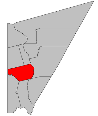
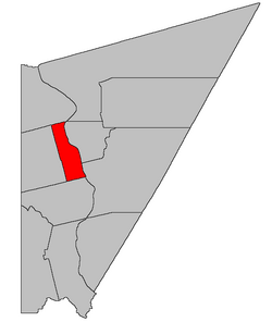
Location within Carleton County, New Brunswick
Coordinates: 46°19′39″N67°33′09″W / 46.3275°N 67.5525°W / 46.3275; -67.5525
Country Flag of Canada (Pantone).svg  Canada
Province Flag of New Brunswick.svg  New Brunswick
County Carleton
Erected1842
Area
[1]
  Land75.57 km2 (29.18 sq mi)
Population
 (2021) [1]
  Total514
  Density6.8/km2 (18/sq mi)
  Change 2016-2021
Increase2.svg 8.7%
  Dwellings
220
Time zone UTC-4 (AST)
  Summer (DST) UTC-3 (ADT)
Figures do not include portion within the town of Florenceville-Bristol

Simonds is a geographic parish in Carleton County, New Brunswick, Canada, [2] located north of Woodstock on the western bank of the Saint John River.

Contents

Prior to the 2023 governance reform, for governance purposes it was comprised one local service district and part of one town, both of which were members of the Western Valley Regional Service Commission (WVRSC). [3]

The Census subdivision of Simonds Parish includes all of the geographic parish except the town of Florenceville-Bristol. [1]

Origin of name

The parish may have been named in honour of Charles Simonds, Speaker of the House of Assembly when the parish was erected, or his family, who were prominent in the early history of the province. [4]

History

Simonds was erected in 1842 from northern Wakefield Parish. [5] It included Wilmot Parish, a narrow wedge of Wicklow Parish, and part of Maine claimed by New Brunswick.

Boundaries

Simonds Parish is bounded: [2] [6] [7]

Evolution of boundaries

Simonds inherited a northern boundary that began at the mouth of Whitemarsh Creek and ran westerly along a line parallel to that of Woodstock Parish, which ran closer to due west than today's line. [5] The western line was implicitly changed a few months after its erection by the Webster–Ashburton Treaty which settled the remainder of New Brunswick's land boundaries with Maine.

In 1850 the consolidation of legislation setting New Brunswick's internal boundaries moved the northern line of Simonds more than a kilometre upriver to the northern line of a grant to Henry M. Green and its prolongation westward, a line which also ran more steeply to the south than the original line. [8] This added a strip of Wicklow Parish that included the northern part of Centreville.

In 1869 the western polling district of Simonds, created in 1867, [9] was erected as Wilmot Parish. [10]

In 1870 the northern boundary was moved south to its current location, [11] transferring territory to Wicklow Parish.

Municipality

The town of Florenceville-Bristol is located at the northeastern corner of the parish, [12] along the Saint John River.

Local service district

The local service district of the parish of Simonds comprised all of the parish that is not part of Florenceville-Bristol. [13]

The LSD was established in 1966 to assess for fire protection. [14] Community services were added in 1967. [15]

In 2020, Simonds assessed for community & recreation services in addition to the basic LSD services of fire protection, police services, land use planning, emergency measures, and dog control. [16] The taxing authority was 214.00 Simonds.

LSD advisory committee: Yes, as of 2018. [17] Chair Tena McLellan sat on the WVRSC board of directors from August 2016 until June 2018. [18] [19] [17]

Communities

Communities at least partly within the parish. [6] [7] [20] bold indicates an incorporated municipality

Bodies of water

Bodies of water [lower-alpha 1] at least partly within the parish. [6] [7] [20]

Islands

Islands at least partly within the parish. [6] [7] [20]

Other notable places

Parks, historic sites, and other noteworthy places at least partly within the parish. [6] [7] [20]

Demographics

Parish population total does not include portion within Florenceville-Bristol

See also

Notes

  1. Not including brooks, ponds or coves.

Related Research Articles

<span class="mw-page-title-main">Saumarez Parish, New Brunswick</span> Parish in New Brunswick, Canada

Saumarez is a geographic parish in Gloucester County, New Brunswick, Canada.

<span class="mw-page-title-main">Kingsclear Parish, New Brunswick</span> Parish in New Brunswick, Canada

Kingsclear is a geographic parish in York County, New Brunswick, Canada.

<span class="mw-page-title-main">Beresford Parish, New Brunswick</span> Parish in New Brunswick, Canada

Beresford is a geographic parish in Gloucester County, New Brunswick, Canada.

<span class="mw-page-title-main">Dumfries Parish, New Brunswick</span> Parish in New Brunswick, Canada

Dumfries is a geographic parish in York County, New Brunswick, Canada.

<span class="mw-page-title-main">Wicklow Parish, New Brunswick</span> Parish in New Brunswick, Canada

Wicklow is a geographic parish in Carleton County, New Brunswick, Canada, forming the northwestern corner of Carleton County.

<span class="mw-page-title-main">Perth Parish, New Brunswick</span> Parish in New Brunswick, Canada

Perth is a geographic parish in Victoria County, New Brunswick, Canada.

<span class="mw-page-title-main">Carleton Parish, New Brunswick</span> Parish in New Brunswick, Canada

Carleton is a geographic parish in Kent County, New Brunswick, Canada.

<span class="mw-page-title-main">Saint-Louis Parish, New Brunswick</span> Parish in New Brunswick, Canada

Saint-Louis is a geographic parish in Kent County, New Brunswick, Canada.

<span class="mw-page-title-main">Kent Parish, New Brunswick</span> Parish in New Brunswick, Canada

Kent is a geographic parish in the northeastern corner of Carleton County, New Brunswick, Canada.

<span class="mw-page-title-main">Peel Parish, New Brunswick</span> Parish in New Brunswick, Canada

Peel is a geographic parish in Carleton County, New Brunswick, Canada, situated on the eastern bank of the Saint John River.

<span class="mw-page-title-main">Wilmot Parish, New Brunswick</span> Parish in New Brunswick, Canada

Wilmot is a geographic parish in Carleton County, New Brunswick, Canada, located along the international border northwest of Woodstock.

<span class="mw-page-title-main">Wakefield Parish, New Brunswick</span> Parish in New Brunswick, Canada

Wakefield is a geographic parish in Carleton County, New Brunswick, Canada, located north on the west bank of the Saint John River north of Woodstock.

<span class="mw-page-title-main">Brighton Parish, New Brunswick</span> Parish in New Brunswick, Canada

Brighton is a geographic parish in Carleton County, New Brunswick, Canada, northeast of Woodstock, extending from the eastern bank of the Saint John River to the York County line.

<span class="mw-page-title-main">Woodstock Parish, New Brunswick</span> Parish in New Brunswick, Canada

Woodstock is a geographic parish in Carleton County, New Brunswick, Canada, surrounding the town of the same name on its landward side.

<span class="mw-page-title-main">Douglas Parish, New Brunswick</span> Parish in New Brunswick, Canada

Douglas is a geographic parish in York County, New Brunswick, Canada.

<span class="mw-page-title-main">Elgin Parish, New Brunswick</span> Parish in New Brunswick, Canada

Elgin is a geographic parish in the interior of Albert County, New Brunswick, Canada, the only one of the county's parishes that does not border either the Bay of Fundy or the Petitcodiac River.

<span class="mw-page-title-main">Simonds Parish, Saint John County, New Brunswick</span> Parish in New Brunswick, Canada

Simonds is a geographic parish in Saint John County, New Brunswick, Canada.

<span class="mw-page-title-main">Pennfield Parish, New Brunswick</span> Parish in Canada

Pennfield is a geographic parish in Charlotte County, New Brunswick, Canada, located west of Saint John located east of St. George and west of Saint John.

<span class="mw-page-title-main">Saint Patrick Parish, New Brunswick</span> Parish in Canada

Saint Patrick is a geographic parish in Charlotte County, New Brunswick, Canada, located west of St. George and Saint Andrews.

<span class="mw-page-title-main">Saint Stephen Parish, New Brunswick</span> Parish in Canada

Saint Stephen is a geographic parish in Charlotte County, New Brunswick, Canada, located in the southwestern corner of the province.

References

  1. 1 2 3 "Census Profile". Statistics Canada. 26 October 2022. Retrieved 30 October 2022.
  2. 1 2 "Chapter T-3 Territorial Division Act". Government of New Brunswick. Retrieved 13 November 2020.
  3. "Communities in each of the 12 Regional Service Commissions (RSC) / Les communautés dans chacune des 12 Commissions de services régionaux (CSR)" (PDF), Government of New Brunswick, July 2017, retrieved 1 February 2021
  4. Ganong, William F. (1896). A Monograph of the Place-Nomenclature of the Province of New Brunswick. Royal Society of Canada. p. 273. Retrieved 17 March 2021.
  5. 1 2 "5 Vic. c. 17 An Act to erect the upper part of the Parish of Wakefield, in the County of Carleton, into a separate and distinct Town or Parish.". Acts of the General Assembly of Her Majesty's Province of New Brunswick, Passed in the Year 1842. Fredericton: Government of New Brunswick. 1842. p. 13. Retrieved 27 March 2021.
  6. 1 2 3 4 5 "No. 91". Provincial Archives of New Brunswick. Department of Natural Resources and Energy Development. Retrieved 27 June 2021. Remainder of parish on map 101 at same site.
  7. 1 2 3 4 5 "271" (PDF). Transportation and Infrastructure. Government of New Brunswick. Retrieved 27 June 2021. Remainder of parish on mapbooks 287, 288, 304, and 305 at same site.
  8. "13 Vic. c. 51 An Act to consolidate all the Laws now in force for the division of the Province into Counties, Towns and Parishes.". Acts of the General Assembly of Her Mjaesty's Province of New Brunswick, Passed in the Year 1850. Fredericton: Government of New Brunswick. 1850. pp. 142–152, 145–149. Retrieved 27 March 2021. Book was poorly proofread, resulting in title typo and reuse of page numbers 145–152.
  9. "30 Vic. c. 26 An Act to establish additional Polling places in the County of Carleton.". Acts of the General Assembly of Her Majesty's Province of New Brunswick, Passed in the Month of June 1867. Fredericton: Government of New Brunswick. 1867. pp. 49–51. Retrieved 27 March 2021.
  10. "32 Vic. c. 52 An Act to erect part of the Parish of Simonds in the County of Carleton into a separate Town or Parish.". Acts of the General Assembly of Her Majesty's Province of New Brunswick. Passed in the Month of April 1869. Fredericton: Government of New Brunswick. 1869. pp. 97–98. Available as a free ebook from Google Books.
  11. "33 Vic. c. 10 An Act to alter the Division Line between the Parish of Wicklow and the Parishes of Simonds and Wilmot, in the County of Carleton.". Acts of the General Assembly of Her Majesty's Province of New Brunswick Passed in the Months of March & April 1870. Fredericton: Government of New Brunswick. 1870. p. 19. Available as a free ebook from Google Books.
  12. "New Brunswick Regulation 85-6 under the Municipalities Act (O.C. 85-45)". Government of New Brunswick. Retrieved 12 January 2021.
  13. "New Brunswick Regulation 84-168 under the Municipalities Act (O.C. 84-582)". Government of New Brunswick. Retrieved 12 January 2021.
  14. "Regulation 66–41 under the Municipalities Act (O. C. 66–968)". The Royal Gazette. 124. Fredericton: 604–605. 21 December 1966.
  15. "Regulation 67–130 under the Municipalities Act (O. C. 67–1196)". The Royal Gazette. 126. Fredericton: 10–11. 3 January 1968.
  16. "2020 Local Government Statistics for New Brunswick" (PDF). Department of Environment and Local Government. p. 55. Retrieved 12 January 2021.
  17. 1 2 "2018 Annual Report" (PDF). Western Valley Regional Service Commission. 2016. p. 2. Retrieved 27 January 2021.
  18. "2016 Annual Report" (PDF). Western Valley Regional Service Commission. 2016. p. 2. Retrieved 27 January 2021.
  19. "2017 Annual Report" (PDF). Western Valley Regional Service Commission. 2016. p. 2. Retrieved 27 January 2021.
  20. 1 2 3 4 "Search the Canadian Geographical Names Database (CGNDB)". Government of Canada. Retrieved 6 July 2021.
  21. Statistics Canada: 1996, 2001, 2006 census
  22. 2011 Statistics Canada Census Profile: Simonds Parish, New Brunswick
  23. "Census Profile, 2016 Census: Simonds, Parish [Census subdivision], New Brunswick". Statistics Canada. Retrieved 29 August 2019.


46°19′39″N67°33′09″W / 46.32750°N 67.55250°W / 46.32750; -67.55250 (Simonds Parish (Carleton), New Brunswick)