
Interstate 29 (I-29) is an Interstate Highway in the Midwestern United States. I-29 runs from Kansas City, Missouri, at a junction with I-35 and I-70, to the Canada–US border near Pembina, North Dakota, where it connects with Manitoba Provincial Trunk Highway 75 (PTH 75), which continues on to Winnipeg. The road follows the course of three major rivers, all of which form the borders of US states. The southern portion of I-29 closely parallels the Missouri River from Kansas City northward to Sioux City, Iowa, where it crosses and then parallels the Big Sioux River. For the northern third of the highway, it closely follows the Red River of the North. The major cities that I-29 connects to includes Council Bluffs, Iowa; Sioux Falls, South Dakota; and Fargo, North Dakota.

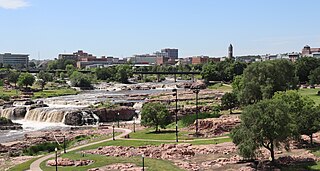
Minnehaha County is a county on the eastern border of the state of South Dakota. As of the 2020 census, the population was 197,214, making it the state's most populous county. It contains over 20% of the state's population. Its county seat is Sioux Falls, South Dakota's largest city. The county was created in 1862 and organized in 1868. Its name was derived from the Sioux word Mnihaha, meaning "rapid water," or "waterfall".

Brandon is a city in Minnehaha County, South Dakota, United States. Brandon is located five miles east of Sioux Falls. The population was 11,048 as of the 2020 census.
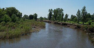
The Big Sioux River is a tributary of the Missouri River in eastern South Dakota and northwestern Iowa in the United States. It flows generally southwardly for 419 mi (674 km), and its watershed is 9,006 sq mi (23,330 km2). The United States Board on Geographic Names settled on "Big Sioux River" as the stream's name in 1931. The river was named after the Lakota people which was known by them as Tehankasandata, or Thick Wooded River.
The Vermillion River is a tributary of the Missouri River, 96 miles (154 km) long, in eastern South Dakota in the United States. The origin of the river name is Waséoyuze, Lakota for "place where vermilion is obtained".
Chester is an unincorporated community and census-designated place (CDP) in Lake County, South Dakota, United States. The population was 257 as of the 2020 census. Chester has been assigned the ZIP code of 57016.

Split Rock Creek State Park is a state park of Minnesota, USA, located in Ihlen, or just south of Pipestone.
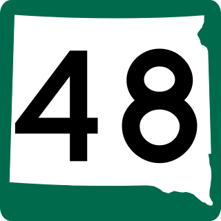
South Dakota Highway 48 is a 12.462-mile (20.056 km) state highway in Union County, South Dakota, United States, that begins at Interstate 29, about 2.5 miles (4.0 km) west of Spink, and becomes Big Sioux River Road, formerly Iowa Highway 403, northwest of Akron, Iowa.

South Dakota Highway 11 (SD 11) is a 77.724-mile (125.085 km) state highway in eastern South Dakota, United States. It connects the northern part of the Sioux City metropolitan area with the Sioux Falls metropolitan area.

The history of South Dakota describes the history of the U.S. state of South Dakota over the course of several millennia, from its first inhabitants to the recent issues facing the state.
The South Dakota Department of Transportation (SDDOT) is a state government organization in charge of maintaining public roadways of the U.S. state of South Dakota. South Dakota has 82,447 miles of highways, roads and streets, as well as 5,905 bridges. The SDDOT is responsible for 7,830 miles of the roadway system.
Shindler is an unincorporated community and census-designated place (CDP) in Lincoln County, South Dakota, United States. The population was 607 at the 2020 census.
Pipestone Creek is a 53.2-mile-long (85.6 km) river in southwestern Minnesota and southeastern South Dakota.
The Iowa Bridge Company was a company that designed and built many bridges that are listed on the U.S. National Register of Historic Places.
This timeline of South Dakota is a list of events in the history of South Dakota by year.
Big Sioux Recreation Area is a South Dakota state recreation area in Minnehaha County, South Dakota in the United States. The recreation area is named for the Big Sioux River which flows through the park. The recreation area is located 4 miles east of Sioux Falls and is very popular for camping, cabin rentals, canoeing, biking, hiking, disc golf, snowmobiling and archery.
Brant Lake South is a census-designated place (CDP) in Lake County, South Dakota, United States. The population was 140 at the 2020 census. It was established after the 2010 census.
