
St. Mary Parish is a parish located in the U.S. state of Louisiana. As of the 2020 census, the population was 49,406. The parish seat is Franklin. The parish was created in 1811.

Iberville Parish is a parish located south of Baton Rouge in the U.S. state of Louisiana, formed in 1807. The parish seat is Plaquemine. The population was 30,241 at the 2020 census.
Pierre Part is a census-designated place (CDP) in Assumption Parish, Louisiana, United States. The population was 3,169 at the 2010 census, making it the most populous community in Assumption Parish. With 39.3 percent of the population speaking French at home, Pierre Part is the most French town in the United States outside of Maine. Pierre Part is known locally for its prominent French influence and ancestry, which have become significant aspects of its contemporary local culture. Situated near Lake Verret, Pierre Part is a popular local destination for water sports and fishing during the summer.
Carlyss is a census-designated place (CDP) in Calcasieu Parish, Louisiana, United States. The population was 5,101 in 2020. It is part of the Lake Charles metropolitan statistical area.
Moss Bluff is a census-designated place (CDP) in Calcasieu Parish, Louisiana, United States. The population was 12,522 at the 2020 census. Located just north of the city of Lake Charles, it is considered a suburb of that city. Moss Bluff is a burgeoning community, and is one of the communities in Calcasieu Parish besides Lake Charles and Sulphur experiencing growth. Several efforts have been made to incorporate Moss Bluff, but at the present time the community is unincorporated.

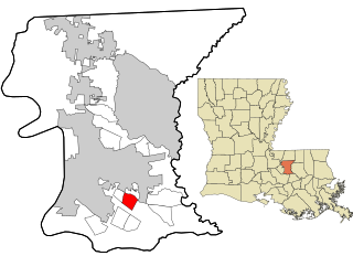
Gardere is an unincorporated area and census-designated place (CDP) in East Baton Rouge Parish, Louisiana, United States. The area is also known as Riverland. The population was 10,580 at the 2010 census, up from 8,992 in 2000. It is part of the Baton Rouge Metropolitan Statistical Area.
Inniswold is an unincorporated area and census-designated place (CDP) in East Baton Rouge Parish, Louisiana, United States. The population was 6,180 at the 2010 census, up from 4,944 in 2000. In 2020, its population was 5,987. It is part of the Baton Rouge metropolitan statistical area.

Merrydale is an unincorporated area and census-designated place (CDP) in East Baton Rouge Parish, Louisiana, United States. The population was 9,772 at the 2010 census, down from 10,427 in 2000. It is part of the Baton Rouge Metropolitan Statistical Area.

Monticello is a census-designated place (CDP) in East Baton Rouge Parish, Louisiana, United States. The population was 5,172 at the 2010 census, up from 4,763 in 2000. It is part of the Baton Rouge Metropolitan Statistical Area.

Shenandoah is an unincorporated area and census-designated place (CDP) in East Baton Rouge Parish, Louisiana, United States. It is part of the Baton Rouge Metropolitan Statistical Area. The population was 18,399 at the 2010 census, up from 17,070 in 2000. Shenandoah consists of a number of residential subdivisions, including Shenandoah Estates, Shenandoah Park, White Oak Landing, White Oak Estates, The Woods and The Lake at White Oak.
Lydia is an unincorporated community and census-designated place (CDP) in Iberia Parish, Louisiana, United States. The population was 952 at the 2010 census, down from 1,079 at the 2000 census. It is part of the New Iberia Micropolitan Statistical Area.
Lafitte is an unincorporated community and census-designated place (CDP) in Jefferson Parish, Louisiana, United States. The population was 972 at the 2010 census, and 816 in 2019. In 2020, its population increased to 1,014 people. It is part of the New Orleans–Metairie–Kenner metropolitan statistical area. Lafitte is located at the southern end of Louisiana Highway 45 along Bayou Barataria, and fishing is a major part of the local economy and culture.
Cut Off is a census-designated place (CDP) on the Bayou Lafourche in Lafourche Parish, Louisiana, United States. The population was 5,533 in 2020. It is part of the Houma–Bayou Cane–Thibodaux metropolitan statistical area. Cut Off's ZIP code is 70345, the area code is 985 and local telephone prefixes are 325, 632 and 693.

Larose is an unincorporated community and census-designated place (CDP) in Lafourche Parish, Louisiana, United States. The population was 6,763 in 2020. It is part of the Houma–Bayou Cane–Thibodaux metropolitan statistical area.

Raceland is an unincorporated community and census-designated place (CDP) on Bayou Lafourche in Lafourche Parish, Louisiana, United States. The population was 9,768 in 2020. It is part of the Houma–Bayou Cane–Thibodaux metropolitan statistical area.
Garyville is a census-designated place (CDP) in St. John the Baptist Parish, Louisiana, United States. The population was 2,775 at the 2000 census and 2,123 in 2020. It is part of the New Orleans–Metairie–Kenner Metropolitan Statistical Area. Garyville has the distinction of being the location of the most recently built oil refinery in the United States; it was established in 1976 by Marathon Petroleum Company.
Amelia is a census-designated place (CDP) in St. Mary Parish, Louisiana, United States. The population was 2,459 at the 2010 census. It is part of the Morgan City Micropolitan Statistical Area.
Bayou Vista is a census-designated place (CDP) in St. Mary Parish, Louisiana, United States. The population was 4,652 at the 2010 census. It is part of the Morgan City Micropolitan Statistical Area.
Glencoe is a census-designated place (CDP) in St. Mary Parish, Louisiana, United States. The population was 126 at the 2010 census. It is part of the Morgan City Micropolitan Statistical Area.
Siracusaville is a census-designated place (CDP) in St. Mary Parish, Louisiana, United States. The population was 422 at the 2010 census. It is part of the Morgan City Micropolitan Statistical Area.

