South Vienna, Ohio

Last updated

South Vienna, Ohio
Main and Urbana in South Vienna.jpg
Main Street in South Vienna
OHMap-doton-South Vienna.png
Location of South Vienna, Ohio
Map of Clark County Ohio Highlighting South Vienna Village.png
Location of South Vienna in Clark County
Coordinates: 39°55′47″N83°37′12″W / 39.92972°N 83.62000°W / 39.92972; -83.62000
Country United States
State Ohio
County Clark
Township Harmony
Government
   Mayor Toni Keller
Area
[1]
  Total0.65 sq mi (1.69 km2)
  Land0.65 sq mi (1.69 km2)
  Water0.00 sq mi (0.00 km2)
Elevation
[2]
1,188 ft (362 m)
Population
 (2020)
  Total402
  Density617.51/sq mi (238.38/km2)
Time zone UTC-5 (Eastern (EST))
  Summer (DST) UTC-4 (EDT)
ZIP code
45369
Area code(s) 937, 326
FIPS code 39-73796 [3]
GNIS feature ID2399860 [2]
Website http://southvienna.org

South Vienna is a village in Clark County, Ohio, United States. The population was 402 at the 2020 census. It is part of the Springfield, Ohio Metropolitan Statistical Area.

Contents

The South Vienna Corn Festival is well known throughout the area, and is held on the weekend after Labor Day. The village also has the distinction of having Permit #1, issued by the State of Ohio for traffic lights.[ citation needed ]

History

South Vienna was originally called Vienna, and under the latter name was platted in 1833. [4] A post office called Vienna Cross Roads was established in 1840, and the name was changed to South Vienna in 1909. [5]

Geography

According to the United States Census Bureau, the village has a total area of 0.52 square miles (1.35 km2), all of it land. [6]

Demographics

Historical population
CensusPop.Note
1910 368
1920 3926.5%
1930 3981.5%
1940 4205.5%
1950 4241.0%
1960 4403.8%
1970 54523.9%
1980 464−14.9%
1990 55018.5%
2000 469−14.7%
2010 384−18.1%
2020 4024.7%
U.S. Decennial Census [7]

2010 census

As of the census [8] of 2010, there were 384 people, 148 households, and 102 families living in the village. The population density was 738.5 inhabitants per square mile (285.1/km2). There were 166 housing units at an average density of 319.2 per square mile (123.2/km2). The racial makeup of the village was 90.4% White, 0.8% African American, 0.5% Native American, 0.5% Asian, 5.7% from other races, and 2.1% from two or more races. Hispanic or Latino of any race were 7.8% of the population.

There were 148 households, of which 35.1% had children under the age of 18 living with them, 48.0% were married couples living together, 16.2% had a female householder with no husband present, 4.7% had a male householder with no wife present, and 31.1% were non-families. 25.0% of all households were made up of individuals, and 8.8% had someone living alone who was 65 years of age or older. The average household size was 2.59 and the average family size was 2.98.

The median age in the village was 40.7 years. 26.8% of residents were under the age of 18; 8.9% were between the ages of 18 and 24; 20.4% were from 25 to 44; 34.4% were from 45 to 64; and 9.6% were 65 years of age or older. The gender makeup of the village was 48.4% male and 51.6% female.

2000 census

As of the census [3] of 2000, there were 469 people, 166 households, and 131 families living in the village. The population density was 1,157.8 inhabitants per square mile (447.0/km2). There were 173 housing units at an average density of 427.1 per square mile (164.9/km2). The racial makeup of the village was 97.65% White, 0.21% African American, 0.85% from other races, and 1.28% from two or more races. Hispanic or Latino of any race were 2.13% of the population.

There were 166 households, out of which 41.0% had children under the age of 18 living with them, 60.2% were married couples living together, 15.7% had a female householder with no husband present, and 20.5% were non-families. 16.9% of all households were made up of individuals, and 5.4% had someone living alone who was 65 years of age or older. The average household size was 2.83 and the average family size was 3.16.

In the village, the population was spread out, with 32.6% under the age of 18, 8.1% from 18 to 24, 28.4% from 25 to 44, 19.6% from 45 to 64, and 11.3% who were 65 years of age or older. The median age was 32 years. For every 100 females there were 92.2 males. For every 100 females age 18 and over, there were 87.0 males.

The median income for a household in the village was $40,625, and the median income for a family was $51,875. Males had a median income of $36,389 versus $25,833 for females. The per capita income for the village was $17,271. About 8.5% of families and 8.2% of the population were below the poverty line, including 1.3% of those under age 18 and 17.9% of those age 65 or over.

Notable people

Related Research Articles

<span class="mw-page-title-main">Brookside, Ohio</span> Village in Ohio, United States

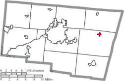
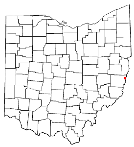
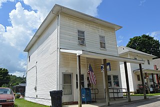
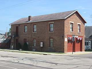
Brookside is a village in eastern Belmont County, Ohio, United States. The population was 538 at the 2020 census. It is part of the Wheeling metropolitan area.

<span class="mw-page-title-main">Donnelsville, Ohio</span> Village in Ohio, United States

Donnelsville is a village in Clark County, Ohio, United States. The population was 255 at the 2020 census. It is part of the Springfield, Ohio Metropolitan Statistical Area.

<span class="mw-page-title-main">New Vienna, Ohio</span> Village in Ohio, United States

New Vienna is a village in Clinton County, Ohio, United States. The population was 1,108 at the 2020 census.

<span class="mw-page-title-main">Castine, Ohio</span> Village in Ohio, United States

Castine is a village in Darke County, Ohio, United States. The population was 110 at the 2020 census.

<span class="mw-page-title-main">Wayne Lakes, Ohio</span> Village in Ohio, United States

Wayne Lakes is a village in Darke County, Ohio, United States. The population was 693 at the 2020 census.

<span class="mw-page-title-main">Riverlea, Ohio</span> Village in Ohio, United States

Riverlea is a village in Franklin County, Ohio, United States, surrounded by Worthington on its north, south, and east sides, and bordered on the west by the Olentangy River, across which is Columbus. Riverlea was incorporated in 1939, a small community that formed on former farmland. The population was 599 at the 2020 census.

<span class="mw-page-title-main">Pleasant City, Ohio</span> Village in Ohio, United States

Pleasant City is a village in Guernsey County, Ohio, United States. The population was 400 at the 2020 census.

<span class="mw-page-title-main">Cleves, Ohio</span> City in Ohio, United States

Cleves is a village in Miami Township, Hamilton County, Ohio, United States. Located along the Ohio River, it is a western suburb of Cincinnati. The population was 3,414 at the 2020 census.

<span class="mw-page-title-main">Evendale, Ohio</span> Village in Ohio, United States

Evendale is a village in Hamilton County, Ohio, United States, within the Cincinnati metropolitan area. The population was 2,669 at the 2020 census.

<span class="mw-page-title-main">Mowrystown, Ohio</span> Village in Ohio, United States

Mowrystown is a village in Highland County, Ohio, United States. The population was 385 at the 2020 census.

<span class="mw-page-title-main">St. Louisville, Ohio</span> Village in Ohio, United States

St. Louisville or Saint Louisville is a village in Licking County, Ohio, United States, along the North Fork of the Licking River. The population was 352 at the 2020 census.

<span class="mw-page-title-main">Grafton, Ohio</span> Village in Ohio, United States

Grafton is a village in Lorain County, Ohio, United States, along the East Branch of the Black River. The population was 5,895 at the 2020 census. The Lorain Correctional Institution and several other prisons are located in and near Grafton.

<span class="mw-page-title-main">Spencer, Ohio</span> Village in Ohio, United States

Spencer is a village in Spencer Township located in Medina County, Ohio, United States. The population was 684 at the 2020 census.

<span class="mw-page-title-main">Covington, Ohio</span> Village in Ohio, United States

Covington is a village in Miami County, Ohio, United States. The population was 2,548 at the 2020 census. It is part of the Dayton Metropolitan Statistical Area. The village was incorporated as Covington in 1835 on the site of the 1793 Fort Rowdy.

<span class="mw-page-title-main">Laura, Ohio</span> Village in Ohio, United States

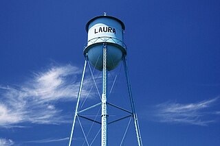
Laura is a village in Miami County, Ohio, United States. The population was 398 at the 2020 census. It is part of the Dayton Metropolitan Statistical Area.

<span class="mw-page-title-main">Williamsport, Ohio</span> Village in Ohio, United States

Williamsport is a village in Pickaway County, Ohio, United States. The population was 970 at the 2020 census.

<span class="mw-page-title-main">Cloverdale, Ohio</span> Village in Ohio, United States

Cloverdale is a village in Perry Township, Putnam County, Ohio, United States. The population was 170 at the 2020 census.

<span class="mw-page-title-main">Gibsonburg, Ohio</span> Village in Ohio, United States

Gibsonburg is a village in Sandusky County, Ohio, United States, about 33 miles (53 km) southeast of Toledo. The population was 2,452 at the 2020 census. The National Arbor Day Foundation has designated Gibsonburg as a Tree City USA.

<span class="mw-page-title-main">Bradner, Ohio</span> Village in Ohio, United States

Bradner is a village in Wood County, Ohio, United States. The population was 971 at the 2020 census.

<span class="mw-page-title-main">Risingsun, Ohio</span> Village in Ohio, United States

Risingsun is a village in Wood County, Ohio, United States. The population was 541 at the 2020 census.

References

  1. "ArcGIS REST Services Directory". United States Census Bureau. Retrieved September 20, 2022.
  2. 1 2 U.S. Geological Survey Geographic Names Information System: South Vienna, Ohio
  3. 1 2 "U.S. Census website". United States Census Bureau . Retrieved January 31, 2008.
  4. Rockel, William Mahlon (1908). 20th Century History of Springfield, and Clark County, Ohio, and Representative Citizens. Biographical Publishing Company. p.  355.
  5. "Clark County". Jim Forte Postal History. Retrieved January 12, 2016.
  6. "US Gazetteer files 2010". United States Census Bureau. Archived from the original on January 25, 2012. Retrieved January 6, 2013.
  7. "Census of Population and Housing". Census.gov. Retrieved June 4, 2015.
  8. "U.S. Census website". United States Census Bureau . Retrieved January 6, 2013.