
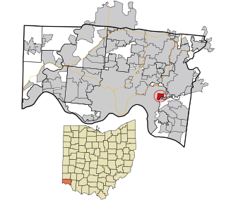
Spencer Township was a civil township in southeastern Hamilton County, Ohio. It was established in the early 1840s and annexed to Cincinnati in stages from 1855 to 1909.
Spencer Township was a civil township in southeastern Hamilton County, Ohio. It was established in the early 1840s and annexed to Cincinnati in stages from 1855 to 1909.

Spencer Township was named after Colonel Oliver Spencer, an early resident of Columbia Township. [1] Statewide, other townships named Spencer are located in Allen, Guernsey, Lucas, and Medina counties.
The land that would become Spencer Township was included in the 1794 Symmes Purchase. It included Columbia, the first white settlement in the historical Miami Valley, in the present-day Columbia-Tusculum neighborhood of Cincinnati. In 1791, the area became part of Columbia Township. [1] [2]
In the early 1840s, Spencer Township was carved out of the suburban southwestern portion of Columbia Township, which was otherwise largely rural. [1]
On January 1, 1855, the shipbuilding village of Fulton, which had already withdrawn from Spencer Township as Fulton Township, was annexed to Cincinnati following a vote by residents of the village. [3] [4]
Spencer Township Hall was built in 1860 to serve as the seat of government as well as the local lodge of the Independent Order of Odd Fellows. [5]
In 1870, Cincinnati annexed East Walnut Hills, O'Bryonville and Mount Lookout. [6] [4] [7] Cincinnati annexed Columbia and Pendleton (not to be confused with the Cincinnati neighborhood of that name) in 1871 [8] and Tusculum in 1875. [9]
As late as 1881, Linwood, East Linwood, Russell's, Turkey Bottom, and part of Red Bank remained within the township. [1] In 1893, Cincinnati annexed Linwood. [8] In August 1909, Cincinnati annexed the southern part of Spencer Township, including Turkey Bottom, on the way to California, which desired the city's police and fire protection after Coney Island opened there. [10] The rest of Spencer Township became part of the city in September 1909 [11] and was attached to Cincinnati Township in October 1909. [12]

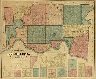
At its inception, Spencer Township was bounded by the Ohio River to the south, Cincinnati and Millcreek Township to the west, Columbia Township to the north, and Anderson Township to the east across the Little Miami River. [13] [14] This area today is wholly located within the Cincinnati city limits, corresponding to parts of Evanston, Hyde Park, Mount Lookout, Columbia-Tusculum, Linwood, and the East End.
In June 1880, there were 2,543 residents in Spencer Township, of whom 995 resided in areas annexed to Cincinnati. [15]
Fairfax is a village in Hamilton County, Ohio, United States. It is a suburb of Cincinnati. The population was 1,768 at the 2020 census.

Reading is a city in Hamilton County, Ohio, United States. The population was 10,600 at the 2020 census. It is an inner suburb of Cincinnati and is included as part of the Cincinnati metropolitan area.

Loveland is a city in Hamilton, Clermont, and Warren counties in the southwestern part of the U.S. state of Ohio. The population was 13,307 at the 2020 census. Considered part of the Cincinnati metropolitan area, Loveland is located near exit 52 off Interstate 275, about 15 miles (24 km) northeast of the Cincinnati city limits. It borders Symmes, Miami and Hamilton townships and straddles the Little Miami River. Once a busy railroad town, Loveland is now a major stop along the Little Miami Scenic Trail.

Columbia Township is one of the twelve townships of Hamilton County, Ohio, United States. The 2020 census found 4,446 people in the township. Originally one of Ohio's largest townships by area at its inception in 1791, it gradually shrank to one of the smallest by the early 1950s.

Springfield Township is one of the twelve townships of Hamilton County, Ohio, United States. The population was 35,862 as of the 2020 census. Springfield Township is home to the largest private school in Ohio, the largest lake in Hamilton County, and the Cincinnati area's annual Greek Festival.
Millcreek Township is a survey township in south-central Hamilton County, Ohio, that also existed as a civil township from 1810 until 1943. Once the most important township in the county, it was largely absorbed by Cincinnati and its suburbs, nominally remaining as a paper township from 1943 until 1953. It was abolished when the rest of its unincorporated territory, consisting of Wesleyan Cemetery, became part of Cincinnati. As the original survey township covers a large portion of present-day Cincinnati, references to it are frequently encountered by genealogists.

Hamilton Township is one of the eleven townships of Warren County, Ohio, United States. It is located in the south central portion of the county. The population was 30,587 at the 2020 census.
The term paper township refers to a civil township under Ohio law that nominally exists for certain purposes but does not act as a functioning unit of civil government. Such townships usually exist on paper as a legal fiction due to municipal annexation.
Ronald Reagan Cross County Highway, formerly and locally known as Cross County Highway, is a west-east freeway in Hamilton County, Ohio, United States. It stretches 16.4 miles (26.4 km) from southern Colerain Township to Montgomery, connecting many of Cincinnati's northern suburbs to Interstate 71 and Interstate 75. State Route 126 is routed over most of the highway, while the remainder is a county-maintained road.

Columbia-Tusculum is one of the 52 neighborhoods of Cincinnati, Ohio. Founded in 1788 and annexed in 1871, it is the city's oldest neighborhood. The population was 1,523 at the 2020 census.

Loveland High School is a public high school located in Loveland, Ohio, United States, within Hamilton County. It is the only high school in the Loveland City School District, serving the communities of Loveland, Symmes Township, Goshen Township, and Miami Township. It offers a range of educational programs, including college preparatory and vocational.

The Hoodin Building was a historic apartment building in the Columbia-Tusculum neighborhood of Cincinnati, Ohio, United States. Built in 1881, it was once one of the neighborhood's most prestigious addresses. Despite its designation as a historic site, it is no longer standing.
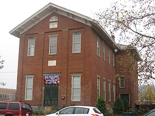
The Spencer Township Hall is a historic former government building in the Columbia-Tusculum neighborhood of Cincinnati, Ohio, United States. One of Cincinnati's oldest extant public buildings, it has been designated a historic site because of its architecture.

Linwood is one of the 52 neighborhoods of Cincinnati, Ohio, United States. Annexed in 1893, it is located in the eastern part of the city. The population was 705 at the 2020 census.

The Pioneer Memorial Cemetery is a historic pioneer cemetery in the Columbia-Tusculum neighborhood of Cincinnati, Ohio, United States. It is located on a small hill overlooking Lunken Airport at 333 Wilmer Avenue on Cincinnati's east side.

John Reily (1763-1850) was a soldier in the American Revolution who later held a number of civic positions including helping draft the Ohio State Constitution. Reily Township in Butler County, Ohio is named for him.
Storrs Township was a civil township in south-central Hamilton County, Ohio. It was established in 1835 and annexed to Cincinnati in 1870 but remained in nominal form until at least 1890 due to an oversight.
Mason City Schools is a city school district that primarily serves Mason and Deerfield Township in Warren County, Ohio, United States. As of 2018, the district has 10,627 students. Its high school, William Mason High School, is the largest in Ohio by enrollment.
Cincinnati Township is a paper township and former civil township in south-central Hamilton County, Ohio. Originally one of Ohio's largest townships by area at its inception in 1791, it was abolished in 1834 when the City of Cincinnati became coextensive with it through annexation. Since then, it has remained solely as a paper township.