Related Research Articles
Randolph County is a county in the northern portion of the U.S. state of Missouri. As of the 2020 census, the population was 24,716. Its county seat is Huntsville. The county was organized January 22, 1829 and named for U.S. Representative and U.S. Senator John Randolph of Roanoke, Virginia.

Lincoln County is located in the eastern part of the U.S. state of Missouri. As of the 2020 census, the population was 59,574. Its county seat is Troy. The county was founded December 14, 1818, and named for Major General Benjamin Lincoln of the American Revolutionary War.

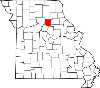
Cooper County is located in the central portion of the U.S. state of Missouri. As of the 2020 United States census, the population was 17,103. Its county seat is Boonville. The county was organized December 17, 1818 and named for Sarshell Cooper, a frontier settler who was killed by Native Americans near Arrow Rock in 1814. It is a part of the Columbia, Missouri metropolitan area.

Cole County is located in the central part of the U.S. state of Missouri. As of the 2020 census, its population was 77,279. Its county seat and largest city is Jefferson City, the state capital. The county was organized November 16, 1820 and named after pioneer William Temple Cole who built Cole's Fort in Boonville.

Clark County is a county located in the U.S. state of Missouri. As of the 2020 census, its population was 6,634. Its county seat is Kahoka. The county was organized December 16, 1836 and named for William Clark, leader of the Lewis and Clark Expedition and later Governor of Missouri Territory.

Doniphan County is the most northeastern county in the U.S. state of Kansas. Its county seat is Troy, and its most populous city is Wathena. As of the 2020 census, the county population was 7,510. The county was named after Alexander Doniphan, a Mexican–American War hero. It is bounded on the east by the Missouri river, south by Atchison county, and west by Brown county.

Atchison County is a county located in the northeast portion of the U.S. state of Kansas. Its county seat and most populous city is Atchison. As of the 2020 census, the county population was 16,348. The county was named in honor of David Atchison, a U.S. Senator from Missouri and border ruffian during the "Bleeding Kansas" era.

Madison County is a county in the U.S. state of Illinois. It is a part of the Metro East in southern Illinois. According to the 2020 census, it had a population of 264,776, making it the eighth-most populous county in Illinois and the most populous in the southern portion of the state. The county seat is Edwardsville, and the largest city is Granite City.

Lawrence County is the easternmost county in the U.S. state of Illinois. At the 2020 census, the population was 15,280. Its county seat is Lawrenceville.
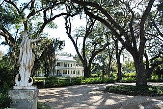
West Feliciana Parish is a civil parish located in the U.S. state of Louisiana. At the 2020 census, the population was 15,310. The parish seat is St. Francisville. The parish was established in 1824.

St. Francisville or Saint Francisville is a city in Lawrence County, Illinois, United States. The population was 697 at the 2010 census.

Godfrey is a village in Madison County, Illinois, United States. The population was 17,825 at the 2020 census. Godfrey is located within the River Bend portion of the Greater St. Louis metropolitan area.

Hartford is a village in Madison County, Illinois, United States, on the Mississippi River near the mouth of the Missouri River. The population was 1,185 at the 2020 census, down from 1,429 in 2010. Lewis and Clark spent the winter of 1803-04 there, near what has been designated the Lewis and Clark State Historic Site.

St. Francisville is a town in and the parish seat of, West Feliciana Parish, Louisiana, United States. The population was 1,557 at the 2020 census. It is part of the Baton Rouge metropolitan statistical area.

Rolla is a city in, and the county seat of, Phelps County, Missouri, United States. Its population in the 2020 United States Census was 19,943. It is approximately midway between St. Louis and Springfield along I-44. Its micropolitan statistical area consists of Phelps County, Missouri.
Bowling Green is a city and the county seat of in Pike County, Missouri, United States. The population was 5,334 at the 2010 census.

Dardenne Prairie is a city in St. Charles County, Missouri, United States. The population was 12,743 at the 2020 census.

Old Jamestown is a census-designated place (CDP) in St. Louis County, Missouri, United States. The population was 19,184 at the 2010 census. Old Jamestown is northwest of the city of St. Louis and borders the Missouri River.
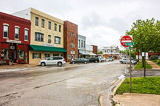
Medill is an unincorporated community and census-designated place in Clark County, in the U.S. state of Missouri. As of the 2020 census, its population was 82.
Marshallville is an unincorporated community and census-designated place (CDP) located in Upper Township, Cape May County, in the U.S. state of New Jersey. It is on the northern edge of the county, bordered to the north, across the Tuckahoe River, by Corbin City in Atlantic County. It is bordered to the east by the unincorporated community of Tuckahoe.
References
- ↑ "ArcGIS REST Services Directory". United States Census Bureau. Retrieved September 5, 2022.
- 1 2 3 U.S. Geological Survey Geographic Names Information System: St. Francisville, Missouri
- ↑ "St. Francisville MO ZIP Code". zipdatamaps.com. 2023. Retrieved June 16, 2023.
- ↑ "2020: DEC Redistricting Data (PL 94-171)". United States Census Bureau . Retrieved November 17, 2021.
- ↑ Missouri Atlas & Gazetteer, DeLorme, First edition, 1998, p. 17 ISBN 0899332242
- ↑ Eaton, David Wolfe (1916). How Missouri Counties, Towns and Streams Were Named. The State Historical Society of Missouri. pp. 276.
- ↑ "Census of Population and Housing". Census.gov. Retrieved June 4, 2016.
Municipalities and communities of Clark County, Missouri, United States | ||
|---|---|---|
| Cities |  | |
| Villages | ||
| Townships | ||
| CDPs | ||
| Other communities | ||
| | This Clark County, Missouri state location article is a stub. You can help Wikipedia by expanding it. |