Wyaconda, Missouri

Last updated

Wyaconda, Missouri
Clark County Missouri Incorporated and Unincorporated areas Wyaconda Highlighted.svg
Location of Wyaconda, Missouri
Coordinates: 40°23′32″N91°55′33″W / 40.39222°N 91.92583°W / 40.39222; -91.92583
Country United States
State Missouri
County Clark
Area
[1]
  Total0.64 sq mi (1.67 km2)
  Land0.64 sq mi (1.66 km2)
  Water0.00 sq mi (0.00 km2)
Elevation
[2]
748 ft (228 m)
Population
 (2020)
  Total214
  Density332.81/sq mi (128.55/km2)
Time zone UTC-6 (Central (CST))
  Summer (DST) UTC-5 (CDT)
ZIP code
63474
Area code 660
FIPS code 29-81142 [3]
GNIS feature ID2397383 [2]

Wyaconda is a city in Clark County, Missouri, United States. As of the 2020 census, its population was 214. [4] The city was organized in 1888 and is named after a Siouan name for God or the Great Spirit. [5] The first land purchased from the Santa Fe and Land Co. was in 1888.

Contents

Wyaconda is part of the Fort MadisonKeokuk, IA-MO Micropolitan Statistical Area.

Geography

Wyaconda is located in western Clark County one mile from the Clark-Scotland county line. The community is at the intersection of Missouri routes A, E and W. Kahoka is approximately eleven miles to the northeast and South Gorin in Scotland County is five miles to the southwest. [6] The Atchison, Topeka and Santa Fe Railroad passes through the community. The South Wyaconda River passes about 1.5 miles to the northeast and the Little Wyaconda River passes about 1.5 miles to the southwest. [7]

According to the United States Census Bureau, the city has a total area of 0.64 square miles (1.66 km2), all land. [8]

Demographics

Historical population
CensusPop.Note
1900 507
1910 480−5.3%
1920 65937.3%
1930 544−17.5%
1940 517−5.0%
1950 483−6.6%
1960 402−16.8%
1970 356−11.4%
1980 3590.8%
1990 347−3.3%
2000 310−10.7%
2010 227−26.8%
2020 214−5.7%
U.S. Decennial Census [9]

2010 census

At the 2010 census, [10] there were 227 people, 108 households and 63 families in the city. The population density was 354.7 inhabitants per square mile (137.0/km2). There were 140 housing units at an average density of 218.8 per square mile (84.5/km2). The racial makeup of the city was 98.2% White and 1.8% from two or more races.

There were 108 households, of which 27.8% had children under the age of 18 living with them, 43.5% were married couples living together, 9.3% had a female householder with no husband present, 5.6% had a male householder with no wife present, and 41.7% were non-families. 38.0% of all households were made up of individuals, and 16.6% had someone living alone who was 65 years of age or older. The average household size was 2.10 and the average family size was 2.76.

The median age was 43.5 years. 24.2% of residents were under the age of 18; 4.7% were between the ages of 18 and 24; 22.1% were from 25 to 44; 30.4% were from 45 to 64; and 18.5% were 65 years of age or older. The population was 49.3% male and 50.7% female.

2000 census

At the 2000 census, [3] there were 310 people, 138 households and 84 families residing in the city. The population density was 479.8 inhabitants per square mile (185.3/km2). There were 171 housing units at an average density of 264.7 per square mile (102.2/km2). The population was 99.68% White, and 0.32% from two or more races.

There were 138 households, of which 23.9% had children under the age of 18 living with them, 47.1% were married couples living together, 10.1% had a female householder with no husband present, and 39.1% were non-families. 34.8% of all households were made up of individuals, and 19.6% had someone living alone who was 65 years of age or older. The average household size was 2.25 and the average family size was 2.87.

22.9% of the population were under the age of 18, 9.0% from 18 to 24, 24.5% from 25 to 44, 22.3% from 45 to 64, and 21.3% who were 65 years of age or older. The median age was 41 years. For every 100 females, there were 84.5 males. For every 100 females age 18 and over, there were 83.8 males.

The median household income was $20,893 and the median family income was $25,000. Males had a median income of $24,107 compared with $15,313 for females. The per capita income was $12,913. About 22.5% of families and 24.1% of the population were below the poverty line, including 43.1% of those under age 18 and 19.2% of those age 65 or over.

Transportation

Amtrak’s Southwest Chief , which operates between Los Angeles and Chicago, passes through the town on BNSF tracks, but makes no stop. The nearest station is located in Fort Madison, 54 miles (87 km) to the northeast.

Related Research Articles

<span class="mw-page-title-main">Rushville, Missouri</span> Village in Missouri, United States

Rushville is a village in western Buchanan County, Missouri, United States. The population was 225 at the 2020 census. It is part of the St. Joseph, MO–KS Metropolitan Statistical Area.

<span class="mw-page-title-main">Luray, Missouri</span> Village in Missouri, United States

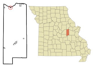
Luray is a village in Clark County, Missouri, United States. As of the 2020 census, its population was 73. It is part of the Fort Madison–Keokuk, IA-MO Micropolitan Statistical Area.

<span class="mw-page-title-main">St. Martins, Missouri</span> City in Missouri, United States

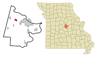
St. Martins or Saint Martins is a city in Cole County, Missouri, United States. The population was 1,191 at the 2020 census. It is part of the Jefferson City, Missouri Metropolitan Statistical Area.

<span class="mw-page-title-main">Gasconade, Missouri</span> City in Missouri, United States

Gasconade is a city in Gasconade County, Missouri. The population is 172 as of the 2020 census.

<span class="mw-page-title-main">Cedar Hill Lakes, Missouri</span> Village in Missouri, United States

Cedar Hill Lakes is a village in Jefferson County, Missouri, United States. The population was 203 at the 2020 census.

<span class="mw-page-title-main">Evergreen, Missouri</span> Village in Missouri, United States

Evergreen is a village in Laclede County, Missouri, United States. The population was 28 at the 2010 census. It was named Twin Bridges at the 2000 census.

<span class="mw-page-title-main">Linneus, Missouri</span> City in Missouri, United States

Linneus is a small city in Linn County, Missouri, United States. The population was 281 at the 2020 census. It is the county seat of Linn County.

<span class="mw-page-title-main">Brumley, Missouri</span> Town in Missouri, United States

Brumley is a town in Miller County, Missouri, United States. The population was 91 at the 2010 census.

<span class="mw-page-title-main">Tracy, Missouri</span> City in Missouri, United States

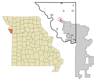
Tracy is a city in Platte County, Missouri within the United States, located along the Platte River. The population was 269 at the 2020 census. The city is part of the Kansas City metropolitan area.

<span class="mw-page-title-main">Flemington, Missouri</span> Village in Missouri, United States

Flemington is a village in Polk County, Missouri, United States. The population was 148 at the 2010 census. It is part of the Springfield, Missouri Metropolitan Statistical Area.

<span class="mw-page-title-main">Miami, Missouri</span> City in Missouri, United States

Miami is a city in Saline County, Missouri, United States. The population was 175 at the 2010 census.

<span class="mw-page-title-main">Nelson, Missouri</span> City in Missouri, United States

Nelson is a city in Saline County, Missouri, United States. The population was 152 at the 2020 census.

<span class="mw-page-title-main">South Gorin, Missouri</span> City in Missouri, United States

South Gorin is a city located in Scotland County, Missouri, United States. As of the 2020 census, its population was 62. The original name of the city was simply "Gorin", and it was changed. The official name for the post office in South Gorin is still Gorin.

<span class="mw-page-title-main">Leadwood, Missouri</span> City in Missouri, United States

Leadwood is a city in St. Francois County, Missouri, United States. The population was 1,282 at the 2010 census.

<span class="mw-page-title-main">Crystal Lake Park, Missouri</span> City in Missouri, United States

Crystal Lake Park is a Missouri Class 4 city in St. Louis County, Missouri, United States. The population was 508 at the 2020 census.

<span class="mw-page-title-main">Grantwood Village, Missouri</span> Town in Missouri, United States

Grantwood Village is a town in St. Louis County, Missouri, United States. The population was 863 at the 2010 census.

<span class="mw-page-title-main">Lakeshire, Missouri</span> City in Missouri, United States

Lakeshire is a city in St. Louis County, Missouri, United States. The population was 1,432 at the 2010 census.

<span class="mw-page-title-main">Pasadena Park, Missouri</span> Village in Missouri, United States

Pasadena Park is a village in St. Louis County, Missouri, United States. The population was 470 at the 2010 census. It is part of the Normandy School District, and is distinct from the city of Pasadena Hills.

<span class="mw-page-title-main">Schell City, Missouri</span> City in Missouri, United States

Schell City is a city in northeast Vernon County, Missouri, United States. The population was 249 at the 2010 census.

<span class="mw-page-title-main">Moline Acres, Missouri</span> City in Missouri, United States

Moline Acres is a city in St. Louis County, Missouri, United States. The population was 2,442 at the 2010 census.

References

  1. "ArcGIS REST Services Directory". United States Census Bureau. Retrieved August 28, 2022.
  2. 1 2 U.S. Geological Survey Geographic Names Information System: Wyaconda, Missouri
  3. 1 2 "U.S. Census website". United States Census Bureau . Retrieved January 31, 2008.
  4. "2020: DEC Redistricting Data (PL 94-171)". United States Census Bureau . Retrieved November 17, 2021.
  5. Eaton, David Wolfe (1916). How Missouri Counties, Towns and Streams Were Named. The State Historical Society of Missouri. pp.  276.
  6. Missouri Atlas & Gazetteer, DeLorme, First edition, 1998, p. 16 ISBN   0899332242
  7. Wyaconda, MO, 7.5 Minute Topographic Quadrangle, USGS, 1951
  8. "US Gazetteer files 2010". United States Census Bureau . Retrieved July 8, 2012.
  9. "Census of Population and Housing". Census.gov. Retrieved June 4, 2015.
  10. "U.S. Census website". United States Census Bureau . Retrieved July 8, 2012.