St George Hanover Square

Last updated

St George Hanover Square
Civil parish
St George's Hanover Square by T Malton. 1787.jpg
The building of the Church of St George's, Hanover Square, prompted the creation of a new parish and select vestry for church and civil purposes
Westminster Civil Parish Map 1870.png
Area
  18511,161 acres (4.70 km2)
  19011,111 acres (4.50 km2)
  19211,110 acres (4.5 km2)
Population
  185173,230
  190176,957
  192167,280
Density
  185163.1/acre
  190169.3/acre
  192160.6/acre
History
  Preceded by St Martin in the Fields
  Origin Commission for Building Fifty New Churches
  Created1724
  Abolished1922
  Succeeded by City of Westminster (parish)
Status Civil parish (1724–1922)
Poor law parish (1834–1870)
GovernmentSt George Hanover Square Vestry (1724–1900)
  Type Vestry
   HQ Vestry Hall, Mount Street, Mayfair
Contained within
  Poor Law UnionSt George's (1870–1913)
City of Westminster (1913–1922)

St George Hanover Square was a civil parish in the metropolitan area of Westminster, Middlesex, later Greater London, England. The creation of the parish accompanied the building of the Church of St George's, Hanover Square, constructed by the Commission for Building Fifty New Churches to meet the demands of the growing population. The parish was formed in 1724 from part of the ancient parish of St Martin in the Fields in the Liberty of Westminster and county of Middlesex. It included some of the most fashionable areas of the West End, including Belgravia and Mayfair. Civil parish administration, known as a select vestry, was dominated by members of the British nobility until the parish adopted the Vestries Act 1831. The vestry was reformed again in 1855 by the Metropolis Management Act. In 1889 the parish became part of the County of London and the vestry was abolished in 1900, replaced by Westminster City Council. The parish continued to have nominal existence until 1922. As created, it was a parish for both church and civil purposes, but the boundaries of the ecclesiastical parish were adjusted in 1830, 1835 and 1865.

Contents

Creation

The New Churches in London and Westminster Act 1710 created the Commission for Building Fifty New Churches with the purpose of building new churches to deal with the increasing population. The commission also chose the boundaries of the new parishes and selected suitable persons to be parish officers and vestrymen. Within the parish were some of the most fashionable areas of the West End of London, with an aristocratic population. The select vestry created by the commission included 100 men. [1] Much of the population of the parish was resident for only part of the year. [2] The parish was created in 1724 from part of the ancient parish of St Martin in the Fields. It was within the Liberty of Westminster [3] [4] and the county of Middlesex. The parish vestry therefore had overlapping jurisdiction with the Westminster Court of Burgesses and the Westminster and Middlesex sessions.

Geography

The northern boundary was Bayswater Road and Oxford Street from Lancaster Gate, past Marble Arch, to Oxford Circus. The western boundary was the River Westbourne. [5] The southern boundary was the River Thames. The parish included the part of Hyde Park northeast of the Serpentine and the Mayfair area. To the south it narrowed, including the Belgravia area, Knightsbridge, Victoria Station and Pimlico. Hanover Square was located near to the northeastern boundary. It included within its boundaries the grounds of Buckingham Palace, although the palace itself was in St Martin in the Fields. [6]

Reform

The parish adopted the Vestries Act 1831, which provided for election of vestrymen by all ratepayers. The aristocratic dominance of the vestry declined. In 1815, 40% of vestrymen had titles and in 1845 it was half that. [7]

In 1855, the parish vestry became a local authority within the area of responsibility of the Metropolitan Board of Works.

Under the Metropolis Management Act 1855 any parish that exceeded 2,000 ratepayers was to be divided into wards; however the parish of St George Hanover Square had already been divided into seven wards by a local act in 1827 - "An Act for better paving, lighting, regulating and improving the parish of Saint George Hanover-square within the liberty of the city of Westminster" (7 Geo. 4). So the incorporated vestry inherited these wards and assigned vestrymen to them: Dover (6), Conduit (9), Grosvenor (12), Brook (15), Curzon (12), Knightsbridge (27) and The Out (27). [8] [9]

Ecclesiastical division

It was initially a parish for both ecclesiastical and civil purposes. However, by 1865 it was divided into eleven ecclesiastical districts. [10]

Poor law

St George was a local act parish and so it did not become part of the New Poor Law system, following the Poor Law Amendment Act 1834. This meant it did not form part of a union and the parish vestry remained in control of poor law functions, instead of a separately elected board of guardians as was typical. Following the Metropolitan Poor Act 1867 (30 & 31 Vict. c. 6), it was joined with St Margaret and St John for this purpose in 1870 as the St George's Union and a board of guardians elected. [11]

Abolition

In 1889 the parish became part of the County of London. The vestry was abolished in 1900 and replaced by Westminster City Council when it became part of the Metropolitan Borough of Westminster. It was abolished as a civil parish in 1922.

Population

Year180118111821183118411851187118811891190119111921
Population [12] 38,44041,68746,38458,20966,55273,23090,02889,57378,36476,95770,10667,280

Notable people

Related Research Articles

<span class="mw-page-title-main">Metropolitan Borough of Camberwell</span> Former Metropolitan Borough in England

Camberwell was a civil parish and metropolitan borough in south London, England. Camberwell was an ancient parish in the county of Surrey, governed by an administrative vestry from 1674. The parish was included in the area of responsibility of the Metropolitan Board of Works in 1855 and became part of the County of London in 1889. The parish of Camberwell became a metropolitan borough in 1900, following the London Government Act 1899, with the parish vestry replaced by a borough council. In 1965 the borough was abolished and its former area became part of the London Borough of Southwark in Greater London.

<span class="mw-page-title-main">Metropolitan Borough of Westminster</span>

The Metropolitan Borough of Westminster was a metropolitan borough in the County of London, England, from 1900 to 1965.

<span class="mw-page-title-main">Metropolitan Borough of Paddington</span> Former borough of London

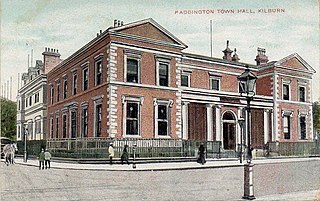
Paddington was a civil parish and metropolitan borough in London, England. It was an ancient parish in the county of Middlesex, governed by an administrative vestry. The parish was included in the area of responsibility of the Metropolitan Board of Works in 1855 and became part of the County of London in 1889. The parish of Paddington became a metropolitan borough in 1900, following the London Government Act 1899, with the parish vestry replaced by a borough council. In 1965 the borough was abolished and its former area became part of the City of Westminster in Greater London.

<span class="mw-page-title-main">Metropolitan Borough of St Marylebone</span> Metropolitan borough of England

The Metropolitan Borough of St Marylebone was a metropolitan borough of the County of London from 1900 to 1965. It was based directly on the previously existing civil parish of St Marylebone, Middlesex, which was incorporated into the Metropolitan Board of Works area in 1855, retaining a parish vestry, and then became part of the County of London in 1889.

<span class="mw-page-title-main">Metropolitan Borough of St Pancras</span> Metropolitan borough of England

St Pancras was a civil parish and metropolitan borough in London, England. It was an ancient parish in the county of Middlesex, governed by an administrative vestry. The parish was included in the area of responsibility of the Metropolitan Board of Works in 1855 and became part of the County of London in 1889. The parish of St Pancras became a metropolitan borough in 1900, following the London Government Act 1899, with the parish vestry replaced by a borough council. In 1965 the borough was abolished and its former area became part of the London Borough of Camden in Greater London.

<span class="mw-page-title-main">Metropolitan Borough of Hampstead</span> Former local authority in London

Hampstead was a civil parish and metropolitan borough in London, England. It was an ancient parish in the county of Middlesex, governed by an administrative vestry. The parish was included in the area of responsibility of the Metropolitan Board of Works in 1855 and became part of the County of London in 1889. The parish of Hampstead became a metropolitan borough in 1900, following the London Government Act 1899, with the parish vestry replaced by a borough council. In 1965 the borough was abolished and its former area became part of the London Borough of Camden in Greater London.

<span class="mw-page-title-main">Metropolitan Borough of Chelsea</span> Former borough of London

The Metropolitan Borough of Chelsea was a metropolitan borough of the County of London between 1900 and 1965. It was created by the London Government Act 1899 from most of the ancient parish of Chelsea. Following the London Government Act 1963, it was amalgamated with the Royal Borough of Kensington in 1965 to form the Royal Borough of Kensington and Chelsea.

<span class="mw-page-title-main">Metropolitan Borough of Bethnal Green</span> Civil parish and metropolitan borough in London, England

Bethnal Green was a civil parish and a metropolitan borough of the County of London between 1899 and 1965, when it was merged with the Metropolitan Borough of Stepney and the Metropolitan Borough of Poplar to form the London Borough of Tower Hamlets.

Shoreditch (St Leonard) was an ancient parish in the county of Middlesex. It was both a civil parish, used for administrative purposes, and an ecclesiastical parish of the Church of England. The parish church is St Leonard's, Shoreditch, often simply called "Shoreditch Church".

<span class="mw-page-title-main">Hackney (parish)</span>

Hackney was a parish in the historic county of Middlesex. The parish church of St John-at-Hackney was built in 1789, replacing the nearby former 16th-century parish church dedicated to St Augustine. The original tower of that church was retained to hold the bells until the new church could be strengthened; the bells were finally removed to the new St John's in 1854. See details of other, more modern, churches within the original parish boundaries below.

Westminster St George's, originally named St George's, Hanover Square, was a parliamentary constituency in Central London. It returned one Member of Parliament (MP) to the House of Commons of the Parliament of the United Kingdom, elected by the first past the post system of election.

Bermondsey was a parish in the metropolitan area of London, England.

<span class="mw-page-title-main">Southwark St George the Martyr</span>

Southwark St George the Martyr was a civil parish in the metropolitan area of London, England and part of the ancient Borough of Southwark. In 1855 the parish vestry became a local authority within the area of responsibility of the Metropolitan Board of Works. It became part of the Metropolitan Borough of Southwark in 1900 and was abolished as a civil parish in 1930.

<span class="mw-page-title-main">Westminster St James</span> United Kingdom legislation

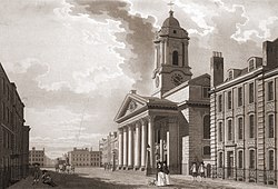
Westminster St James was a civil parish in the metropolitan area of London, England. The creation of the parish followed the building of the Church of St James, Piccadilly, in 1684. After several failed attempts, the parish was formed in 1685 from part of the ancient parish of St Martin in the Fields in the Liberty of Westminster and county of Middlesex. It included part of the West End of London, taking in sections of Soho, Mayfair and St James's. Civil parish administration was in the hands of a select vestry until the parish adopted the Vestries Act 1831. The vestry was reformed again in 1855 by the Metropolis Management Act. In 1889 the parish became part of the County of London and the vestry was abolished in 1900, replaced by Westminster City Council. The parish continued to have nominal existence until 1922.

<span class="mw-page-title-main">St Martin in the Fields (parish)</span>

St Martin in the Fields was a civil parish in the county of Middlesex, later part of the new County of London, England. It took its name from the Church of St Martin-in-the-Fields and was within the Liberty of Westminster. Within its boundaries were the former extra-parochial areas of Buckingham Palace and St James's Palace.

<span class="mw-page-title-main">St Anne Within the Liberty of Westminster</span>

St Anne Within the Liberty of Westminster, also known as St Anne Soho, was a civil parish in the county of Middlesex, later part of the new County of London, England.

<span class="mw-page-title-main">Westminster St Margaret and St John</span>

St Margaret was an ancient parish in the City and Liberty of Westminster and the county of Middlesex. It included the core of modern Westminster, including the Palace of Westminster and the area around, but not including Westminster Abbey. It was divided into St Margaret's and St John's in 1727, to coincide with the building of the Church of St John the Evangelist, constructed by the Commission for Building Fifty New Churches in Smith Square to meet the demands of the growing population, but there continued to be a single vestry for the parishes of St Margaret and St John. This was reformed in 1855 by the Metropolis Management Act, and the two parishes formed the Westminster District until 1887. St Margaret and St John became part of the County of London in 1889. The vestry was abolished in 1900, to be replaced by Westminster City Council, but St Margaret and St John continued to have a nominal existence until 1922.

Hackney was a local government district within the metropolitan area of London, England from 1855 to 1894. It was formed by the Metropolis Management Act 1855 and was governed by the Hackney District Board of Works, which consisted of elected vestrymen. It was in the part of the county of Middlesex that was within the area of the Metropolitan Board of Works. In 1889 it became part of the County of London and the district board functioned as a local authority under the London County Council.

<span class="mw-page-title-main">St George in the East (parish)</span>

St George in the East, historically known as Wapping-Stepney, was an ancient parish, in the London Borough of Tower Hamlets, England. The place name is no longer widely used.

<span class="mw-page-title-main">Vestries Act 1831</span> United Kingdom legislation

The Vestries Act 1831, commonly known as Hobhouse's Vestry Act, was an Act of Parliament in 1831 and was a local government overhaul which also affected the Established Church at a local level. The act gave subsidiarity in that local ratepayers would have to agree by a special majority for the reform to take effect in their local area (parish).

References

  1. "Introduction | The Commissions for building fifty new churches (pp. IX-XXXIII)". British-history.ac.uk. 22 June 2003. Retrieved 11 September 2013.
  2. "St George'S Hanover Square". Stgeorgeshanoversquare.org. Retrieved 11 September 2013.
  3. Youngs, Frederic (1979). Guide to the Local Administrative Units of England. Vol. I: Southern England. London: Royal Historical Society. ISBN   0-901050-67-9.
  4. "Wellcome Collection | A free museum and library exploring health and human experience" (PDF).
  5. London's Lost Rivers, Paul Talling, Random House, 2011
  6. Sir Walter Besant and Geraldine Edith Mitton(1903). The Strand District , The Fascination of London.Adam and Charles Black at Project Gutenberg
  7. Liberalism and Local Government in Early Victorian London, Benjamin Weinstein
  8. The London Gazette Issue: 21802. 20 October 1855. pp. 3875–3876. Retrieved 8 April 2015.
  9. "H.M.S.O. Boundary Commission Report 1885 Westminster Map". Vision of Britain. Retrieved 8 April 2015.
  10. "Background - Westminster". London Lives. Retrieved 11 September 2013.
  11. Peter Higginbotham. "The St George's Union, Middlesex". Workhouses.org.uk. Retrieved 11 September 2013.
  12. "St George Hanover Square CP/Vest through time | Population Statistics | Total Population". Visionofbritain.org.uk. Retrieved 11 September 2013.

51°30′45″N0°8′35″W / 51.51250°N 0.14306°W / 51.51250; -0.14306