Westminster is an area of Central London, part of the wider City of Westminster.

Strand is a major thoroughfare in the City of Westminster, Central London. It runs just over 3⁄4 mile (1,200 m) from Trafalgar Square eastwards to Temple Bar, where the road becomes Fleet Street inside the City of London, and is part of the A4, a main road running west from inner London.

The Metropolitan Borough of Westminster was a metropolitan borough in the County of London, England, from 1900 to 1965.

St Mary le Strand is a Church of England church at the eastern end of the Strand in the City of Westminster, London. It lies within the Deanery of Westminster within the Diocese of London. The church stands on what was until recently a traffic island to the north of Somerset House, King's College London's Strand campus, and south of Bush House. It is the official church of the Women's Royal Naval Service, and has a book of remembrance for members who have died in service. The nearest tube station is Temple, with the now-closed Aldwych station nearly opposite the church. It is known as one of the two 'Island Churches', the other being St Clement Danes.
The Holborn Division was one of four divisions of the Hundred of Ossulstone, in the county of Middlesex, England. The other divisions were named Finsbury, Kensington and Tower.

The City and Liberty of Westminster was a unit of local government in the county of Middlesex, England. It was located immediately to the west of the City of London. Originally under the control of Westminster Abbey, the local authority for the area was the Westminster Court of Burgesses from 1585 to 1900. The area now forms the southern part of the City of Westminster in Greater London.
The Precinct of the Savoy, also known as Savoy St John the Baptist, was a component of the Liberty of the Savoy in the metropolitan area of London, England. It was located between the Strand and the River Thames. Formerly extra-parochial, it was a civil parish between 1866 and 1922. It now forms part of the City of Westminster in Greater London.
The Savoy was a manor and liberty sandwiched between the Liberty of Westminster, on two sides, the Inner and Middle Temple corner of City of London and a steep bank of the Tideway. It was in the county of Middlesex. It was all held by the Duchy of Lancaster, and was also known as the Liberty of the Duchy of Lancaster. The duchy (monarch) has kept some reversionary interests and the Savoy Chapel outright. The manor, enjoying the status of a liberty, comprised the precinct of the Savoy, the southern half and detached south-west of the parish of St Clement Danes and about three quarters of St Mary le Strand as it only, in a tiny part, extended north of the Strand whereas those parishes straddled this ancient road.
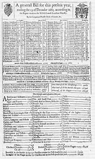
Bills of mortality were the weekly mortality statistics in London, designed to monitor burials from 1592 to 1595 and then continuously from 1603. The responsibility to produce the statistics was chartered in 1611 to the Worshipful Company of Parish Clerks. The bills covered an area that started to expand as London grew from the City of London, before reaching its maximum extent in 1636. New parishes were then only added where ancient parishes within the area were divided. Factors such as the use of suburban cemeteries outside the area, the exemption of extra-parochial places within the area, the wider growth of the metropolis, and that they recorded burials rather than deaths, rendered their data incomplete. Production of the bills went into decline from 1819 as parishes ceased to provide returns, with the last surviving weekly bill dating from 1858. They were superseded by the weekly returns of the Registrar General from 1840, taking in further parishes until 1847. This area became the district of the Metropolitan Board of Works in 1855, the County of London in 1889 and Inner London in 1965.

St. Martin's Le Grand is a former liberty within the City of London, and is the name of a street north of Newgate Street and Cheapside and south of Aldersgate Street. It forms the southernmost section of the A1 road.
The Worshipful Company of Parish Clerks is one of the Guilds of the City of London. It has no livery, because "[i]n the 16th century, the Parish Clerks declined to take the Livery on the grounds that the surplice was older than the Livery and was the proper garb of members of the Company." It is not, therefore, technically a livery company although to all intents and purposes it acts as such. It is one of two such historic companies without livery, the other being the Company of Watermen and Lightermen.
Strand was a local government district within the metropolitan area of London, England, from 1855 to 1900.

St George Hanover Square was a civil parish in the metropolitan area of London, England. The creation of the parish accompanied the building of the St George's Hanover Square Church, constructed by the Commission for Building Fifty New Churches to meet the demands of the growing population. The parish was formed in 1724 from part of the quite early medieval parish of Saint Martin in the Fields in the consequent Liberty of Westminster, hundred of Ossulstone and county of Middlesex. It included some of the most fashionable areas of the West End of London, including Belgravia and Mayfair. Civil parish administration, known as a select vestry, was dominated by members of the British nobility until the parish adopted the Vestries Act 1831. The vestry was reformed again in 1855 by the Metropolis Management Act. In 1889 the parish became part of the County of London and the vestry was abolished in 1900, replaced by Westminster City Council. The parish continued to have nominal existence until 1922. As created, it was a parish for both church and civil purposes, but the boundaries of the ecclesiastical parish were adjusted in 1830, 1835 and 1865.
Westminster St James was a civil parish in the metropolitan area of London, England. The creation of the parish followed the building of the Church of St James, Piccadilly in 1684. After several failed attempts, the parish was formed in 1685 from part of the ancient parish of St Martin in the Fields in the Liberty of Westminster and county of Middlesex. It included part of the West End of London, taking in sections of Soho, Mayfair and St James's. Civil parish administration was in the hands of a select vestry until the parish adopted the Vestries Act 1831. The vestry was reformed again in 1855 by the Metropolis Management Act. In 1889 the parish became part of the County of London and the vestry was abolished in 1900, replaced by Westminster City Council. The parish continued to have nominal existence until 1922.
St Clement Danes was a civil parish in the metropolitan area of London, England; an ecclesiastical version remains. The parish was split between the Liberty of Westminster and the Liberty of the Duchy of Lancaster. The area is colloquially split between Aldwych and Adelphi areas associated with the larger Strand area in the extreme east of the City of Westminster. It includes hotels, restaurants, the Indian and Australian High Commissions and the London School of Economics. To its west is Charing Cross station which faces Trafalgar Square.
St Martin-in-the-Fields was a civil parish in the metropolitan area of London, England. It took its name from the church of St Martin-in-the-Fields and was within the Liberty of Westminster. It included within its boundaries the former extra-parochial areas of Buckingham Palace and St James's Palace.
St Paul Covent Garden was a civil parish in the metropolitan area of London, England. The former area of the parish now corresponds to the Covent Garden market and surrounding streets in the City of Westminster.
St Anne Within the Liberty of Westminster, also known as St Anne Soho, was a civil parish in the metropolitan area of London, England. The creation of the parish accompanied the building of St Anne's Church, Soho to meet the demands of the growing population. The parish was formed in 1687 from part of the ancient parish of St Martin in the Fields in the Liberty of Westminster and county of Middlesex. It included the eastern section of the contemporary districts of Soho to the north of Shaftesbury Avenue and Chinatown to the south of it. Initially controlled by a select vestry, the parish was governed by an open vestry of all inhabitants until 1855, when the vestry was superseded for most purposes by the Strand District Board of Works. In 1889 the parish became part of the County of London and in 1900 the local authority became Westminster City Council. The parish continued to have nominal existence until 1922.

The Cleveland Street Workhouse is a Georgian property in Cleveland Street, Marylebone, built between 1775 and 1778 for the care of the sick and poor of the parish of St Paul Covent Garden under the Old Poor Law. From 1836, it became the workhouse of the Strand Union of parishes. The building remained in operation until 2005 after witnessing the complex evolution of the healthcare system in England. After functioning as a workhouse, the building became a workhouse infirmary before being acquired by the Middlesex Hospital and finally falling under the NHS. In the last century it was known as the Middlesex Hospital Annexe and the Outpatient Department. It closed to the public in 2005 and it has since been vacated. On 14 March 2011 the entire building became Grade II Listed. Development of the site began in 2019 by current owner University College London Hospitals (UCLH) Charity as a mixed-use development including residential, commercial and open space, but construction has been held up by the necessity to remove human remains stemming from the use of the area around the workhouse as a parish burial ground between 1780 and 1853. There has also been controversy about the amount of social housing to be included in the development.