
Interstate 80 (I-80) is an east–west transcontinental freeway that crosses the United States from downtown San Francisco, California, to Teaneck, New Jersey, in the New York metropolitan area. The highway was designated in 1956 as one of the original routes of the Interstate Highway System; its final segment was opened in 1986. The second-longest Interstate Highway in the United States after I-90, it runs through many major cities, including Oakland, Sacramento, Reno, Salt Lake City, Omaha, Des Moines, and Toledo and passes within 10 miles (16 km) of Chicago, Cleveland, and New York City.

Kosciusko County is a county in the U.S. state of Indiana. At the 2020 United States Census, its population was 80,240. The county seat is Warsaw.

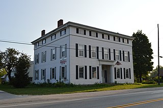
Genoa is a village in Ottawa County, Ohio, United States. The population was 2,232 at the 2020 census. Originally settled as Stony Ridge, it took its present name in 1856 and was incorporated as a village on September 7th, 1868.

The Hoosier National Forest is a property managed by the United States Forest Service in the hills of southern Indiana. Composed of four separate sections, it has a total area of 202,814 acres. Hoosier National Forest's headquarters are located in Bedford, with a regional office in Tell City. Prominent places within the Forest include the Lick Creek Settlement, Potts Creek Rockshelter Archeological Site, and Jacob Rickenbaugh House.

Stony Cove Pike is a fell in the Far Eastern part of the English Lake District. It stands on the other side of the Kirkstone Pass from Red Screes, and is on the end of a ridge coming down from High Street. It is separated from its neighbours by the deep col of Threshthwaite Mouth, so is a Marilyn – the sixteenth highest in the Lake District.

Lake Chicago was a prehistoric proglacial lake that is the ancestor of what is now known as Lake Michigan, one of North America's five Great Lakes. Formed about 13,000 years ago and fed by retreating glaciers, it drained south through the Chicago Outlet River.

State Route 40 is a primary state highway in the southern part of the U.S. state of Virginia. It runs from SR 8 at Woolwine east to SR 10 at Spring Grove, about half the width of Virginia. It is the longest state-numbered route in Virginia.

The A6187 is a secondary route in the Peak District, Derbyshire and South Yorkshire, England. It starts in Castleton, runs in an easterly direction past Fox House Inn where it joins the A625 road. It is 13.6 miles long.
Stony Ridge is a census-designated place (CDP) in northwestern Troy Township, Wood County, Ohio, United States. As of the 2020 census, it had a population of 434. It has a post office with the ZIP code 43463.

Plain Township is one of seventeen townships in Kosciusko County, Indiana. As of the 2010 census, its population was 7,698 and it contained 3,679 housing units.
Fishersburg is an unincorporated community and census-designated place (CDP) in Stony Creek Township, Madison County, Indiana, United States.

Stony Lonesome is an unincorporated community in Harrison Township, Bartholomew County, in the U.S. state of Indiana.
Bloomer is an unincorporated community in Stony Creek Township, Madison County, Indiana.

Plateau Mountain is located in the town of Hunter in Greene County, New York, United States. It is part of the Devil's Path range of the Catskill Mountains. Plateau has a two-mile-long (3.2 km) summit ridge above 3,500 feet (1,100 m). The highest point, at least 3,840 feet (1,170 m), is at the southeast end, facing Sugarloaf Mountain to the east across Mink Hollow Notch. It is the 12th-highest peak in the range Devils Tombstone is located west of Plateau Mountain. The northwest end faces Hunter Mountain to the west across 1,400-foot deep (430 m) Stony Clove Notch.

The Fowler Ridge Wind Farm is a wind farm in Benton County, Indiana, near the city of Fowler, IN about 30 miles (48 km) northwest of Lafayette and 90 miles (140 km) northwest of Indianapolis. Fowler Ridge was originally developed in 2005 and 2006 by Orion Energy, LLC and Vision Energy, LLC and later sold in 2007 to BP and Dominion Resources. The project was constructed beginning in 2008 in two phases and has a nameplate capacity of 600 MW.
Stony Ridge may refer to:
Fire Scale Mountain is a mountain in the North Carolina High Country, near the community of Deep Gap. The majority of the mountain is within the Blue Ridge Parkway. Its elevation reaches 3,845 feet (1,172 m).
Stony Creek is an unincorporated community in LaGrange County, Indiana, in the United States.

Stony Man Mountain, also known as Stony Man, is a mountain in Shenandoah National Park, Virginia and is the most northerly 4,000 foot peak in the Blue Ridge Mountains. Its maximum elevation is 4,011 feet or 1,223 meters above sea level with a clean prominence of 651 feet. The mountain is co-located in Madison and Page counties and is easily accessed from Skyline Drive by hiking trails. Along with Hawksbill Mountain, it is only one of two peaks in the park higher than 4,000 feet. The shortest route to the summit is from the Skyland Resort and gains less than 400 vertical feet in about 1 kilometer. A longer, more challenging, route is from the Skyline Drive trail head at about milepost 39 of the Skyline Drive and gains almost 800 feet. The peak sits just southeast of the Appalachian Trail (AT) but the summit is accessible from the AT by previously mentioned spur trails. On the upper slopes of Stony Man one can see a few red spruce and balsam fir trees which typically grow in more northerly latitudes. The mountain is composed of ancient basalt which was metamorphosed into Greenstone through heat and pressure.


