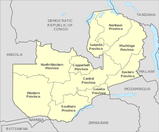
Zambia is divided into ten provinces, [1] each administered by an appointed deputy minister. Each province is divided into several districts with a total of 116 districts. The provinces are:

Zambia is divided into ten provinces, [1] each administered by an appointed deputy minister. Each province is divided into several districts with a total of 116 districts. The provinces are:

The flag of Zambia is the national flag of Zambia. It was adopted upon independence on 24 October 1964, by the first Republican President Dr. Kenneth David Kaunda. Before that, Zambia was the British protectorate of Northern Rhodesia and used a defaced Blue Ensign as its flag.

Zambia is divided into 10 provinces for administrative purposes. Each province is headed by a minister appointed by the President and there are ministries of central government for each province. The administrative head of the province is the Permanent Secretary, appointed by the President. There are Deputy Permanent Secretary, heads of government departments and civil servants at the provincial level.

For administrative purposes, Papua New Guinea is divided into administrative divisions called provinces. There are 22 provincial-level divisions, which include 20 provinces, the Autonomous Region of Bougainville, and the National Capital District of Port Moresby.

Northern Province is one of Zambia's ten provinces. It covers approximately one sixth of Zambia in land area. The provincial capital is Kasama. The province is made up of 12 districts, namely Kasama District, Chilubi District, Kaputa District, Luwingu District, Mbala District, Mporokoso District, Mpulungu District, Mungwi District, Nsama District, Lupososhi District, Lunte District and Senga Hill District. Currently, only Kasama and Mbala have attained municipal council status, while the rest are still district councils. It is widely considered to be the heartland of the Bemba, one of the largest tribes in Zambia.

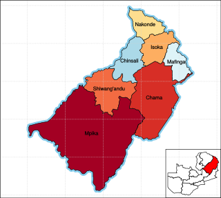
Isoka is a town located in the Muchinga Province of Zambia near the borders with Tanzania and Malawi. It lies on the T2 Road.

Eastern Province is one of Zambia's ten provinces. The province lies between the Luangwa River and borders with Malawi to the east and Mozambique to the south, from Isoka in the northeast to the north of Luangwa in the south. The provincial capital is Chipata. Eastern province has an area of 51,476 km2 (19,875 sq mi), locally shares border with three other provinces of the country and is divided into eleven districts.

Luapula Province is one of Zambia's ten provinces located in the northern part of the country. Luapula Province is named after the Luapula River and its capital is Mansa. As per the 2010 Zambian census, the Province had a population of 991,927, which accounted for 7.57 per cent of the total Zambian population.

Southern Province is one of Zambia's ten provinces, and home to Zambia's premier tourist attraction, Mosi-oa-Tunya, shared with Zimbabwe. The centre of the province, the Southern Plateau, has the largest area of commercial farmland of any Zambian province, and produces most of the maize crop.

The ten provinces of Zambia are divided into a total of 116 districts as of 2018.
For administrative purposes, Papua New Guinea (PNG) is divided into administrative divisions called regions and provinces. Papua New Guinea is divided into four regions and 22 province-level divisions: 20 provinces plus the autonomous region (Bougainville) and the National Capital District.
Zambian Traditional Ceremonies.

The following outline is provided as an overview of and topical guide to Zambia:

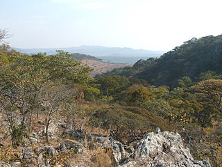
Chitemene, from the ciBemba word meaning “place where branches have been cut for a garden”, is a system of slash and burn agriculture practiced throughout northern Zambia. It involves coppicing or pollarding of standing trees in a primary or secondary growth Miombo woodland, stacking of the cut biomass, and eventual burning of the cut biomass in order to create a thicker layer of ash than would be possible with in situ burning. Crops such as maize, finger millet, sorghum, or cassava are then planted in the burned area.

Chama District with the headquarters at Chama is the largest district of the Eastern Province in Zambia and includes a large wilderness in the Upper Luangwa valley just north-east of the North Luangwa National Park. It is made up of two constituencies, namely Chama North and Chama South.

Chinsali District with headquarters at Chinsali is located in Muchinga Province, Zambia.
The Chess Federation of Zambia is the national organization for chess in Zambia. The headquarters are in Lusaka, capital of the country. The president is Mukubulo Chilufya. The vice president is Leslie Chikuse. The Secretary General is Chanda Nsakanya. The Chess Federation of Zambia is affiliated to the World Chess Federation (FIDE) and to the African Chess Union. It organizes national tournaments such as the National Individual Chess Championships, Zambian Closed Chess Championships and the Zambia Open Chess Championships].

Muchinga Province is one of the ten provinces of Zambia. It is located in the northeast of the country and borders with Tanzania in the north, Malawi in the east, Eastern Province in the south, Central Province in the southwest, Luapula Province in the west, and Northern Province in the northwest. The administrative center of the province is Chinsali.
The Zambian Second Division, also known as Division due to sponsorship reasons, was the second division of the Football Association of Zambia. But the league pyramid was restructured before the season of 2019/20 when they also changed the league calendar to match the CAF calendar. For the new second highest league see Zambia National Division One. The League consisted of 64 teams that are distributed into four zones.

Samar was a province in the Philippines which is coterminous with the island of Samar and its outlying islands.
The 2010 Zambian census was conducted in Zambia in 2010 under the approval of the Government of Zambia, which recorded demographic data from 13 million people and 3.2 million households. The 2010 Census of Population and Housing was conducted between 16 October and 15 November 2010, with all parts of the country covered by 30 November 2010. It was the fifth national population census exercise of Zambia since its independence in 1964, with the previous censuses conducted in 1969, 1980, 1990 and 2000. A total of 3.2 million questionnaires were used for data collection and the processing started in April 2011 by the Central Statistical Office. Optical Mark Reading (OMR) and Intelligent Character Recognition (ICR) technology were used for data capture. The census was funded by United Nations Population Fund (UNFPA), the United Kingdom AID, the United States Agency for International Development (USAID) and the African Development Bank (AfDB), who contributed close to 60 per cent of the total expenditure and rest contributed by the Ministry of Finance of the Government of Zambia.