Sugar Bush, Outagamie County, Wisconsin

Last updated
Sugar Bush, Wisconsin
USA Wisconsin location map.svg
Red pog.svg
Sugar Bush, Wisconsin
Usa edcp location map.svg
Red pog.svg
Sugar Bush, Wisconsin
Coordinates: 44°28′54″N88°44′9″W / 44.48167°N 88.73583°W / 44.48167; -88.73583 Coordinates: 44°28′54″N88°44′9″W / 44.48167°N 88.73583°W / 44.48167; -88.73583
Country Flag of the United States.svg  United States
State Flag of Wisconsin.svg  Wisconsin
County Outagamie
Elevation
250 m (830 ft)
Time zone UTC-6 (Central (CST))
  Summer (DST) UTC-5 (CDT)

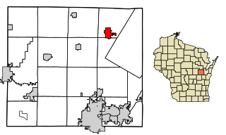
Sugar Bush is an unincorporated community located entirely within the town of Maple Creek in northwest Outagamie County, Wisconsin, United States. [1] Sugar Bush is classified as a Class U6 Community by the USGS, being a populated place located wholly or substantially outside the boundaries of any incorporated place or CDP with a recognized authoritative common name.

Unincorporated area Region of land not governed by own local government

In law, an unincorporated area is a region of land that is not governed by a local municipal corporation; similarly an unincorporated community is a settlement that is not governed by its own local municipal corporation, but rather is administered as part of larger administrative divisions, such as a township, parish, borough, county, city, canton, state, province or country. Occasionally, municipalities dissolve or disincorporate, which may happen if they become fiscally insolvent, and services become the responsibility of a higher administration. Widespread unincorporated communities and areas are a distinguishing feature of the United States and Canada. In most other countries of the world, there are either no unincorporated areas at all, or these are very rare; typically remote, outlying, sparsely populated or uninhabited areas.

Maple Creek, Wisconsin Town in Wisconsin, United States

Maple Creek is a town in Outagamie County, Wisconsin, United States. The population was 687 at the 2000 census. The unincorporated community of Sugar Bush is located in the town.

Outagamie County, Wisconsin County in the United States

Outagamie is a county in the northeast region of the U.S. state of Wisconsin. As of the 2010 census, the population was 176,695. Its county seat is Appleton.

Contents

Sugar Bush is located 6 miles (9.7 km) north of New London, 10 miles (16 km) south of Clintonville and 40 miles (64 km) west of Green Bay.

New London, Wisconsin City in Wisconsin, United States

New London is a city in Outagamie and Waupaca Counties in the U.S. state of Wisconsin. Founded in 1851, the population was 7,295 at the 2010 census. Of this, 5,685 were in Waupaca County, and 1,640 were in Outagamie County. The city has a Saint Patrick's Day Parade, Irish Fest, and week-long festivities, when the city's name is changed to "New Dublin" for the week.

Clintonville, Wisconsin City in Wisconsin, United States

Clintonville is a city in Waupaca County, Wisconsin, United States. The population was 4,559 at the 2010 census. The area that became Clintonville was first settled in March, 1855.

Green Bay, Wisconsin City in Wisconsin, United States

Green Bay is a city in and the county seat of Brown County in the U.S. state of Wisconsin, at the head of Green Bay, a sub-basin of Lake Michigan, at the mouth of the Fox River. It is 581 feet (177 m) above sea level and 112 miles (180 km) north of Milwaukee. The population was 104,057 at the 2010 census. Green Bay is the third-largest city in the state of Wisconsin, after Milwaukee and Madison, and the third-largest city on Lake Michigan's west shore, after Chicago and Milwaukee. Green Bay is home to the National Football League's Green Bay Packers.

Postal service is provided by the New London post office, ZIP code 54961.

History

The Sugar Bush post office operated from 1858 until 1972. [2] The community was named from a grove of sugar maples near the town site. [3]

Geography

Sugar Bush is located at 44°28′54″N88°44′9″W / 44.48167°N 88.73583°W / 44.48167; -88.73583 (44.4816467, -88.7359322), and the elevation is 830 feet (250 m). [1]

Education

The School District of New London operates an elementary school in Sugar Bush.

Transportation

Sugar Bush is located on Outagamie County Highway WW, immediately east of U.S. Highway 45, a major north-south corridor in the State of Wisconsin, and just west of Outagamie County Highway D.

U.S. Route 45 in Wisconsin highway in Wisconsin

U.S. Highway 45 runs north–south through the eastern and northern portions of the state of Wisconsin. Also called Highway 45, it runs from the state line with Illinois near the village of Bristol in Kenosha County to the Michigan state line at the town of Land O' Lakes in Vilas County, a total of about 305 miles (491 km).

Wisconsin A north-central state of the United States of America

Wisconsin is a U.S. state located in the north-central United States, in the Midwest and Great Lakes regions. It is bordered by Minnesota to the west, Iowa to the southwest, Illinois to the south, Lake Michigan to the east, Michigan to the northeast, and Lake Superior to the north. Wisconsin is the 23rd largest state by total area and the 20th most populous. The state capital is Madison, and its largest city is Milwaukee, which is located on the western shore of Lake Michigan. The state is divided into 72 counties.

Related Research Articles

Shawano County, Wisconsin County in the United States

Shawano County is a county located in the U.S. state of Wisconsin. As of the 2010 census, the population was 41,949. Its county seat is Shawano.

Calumet County, Wisconsin County in the United States

Calumet County is a county located in the U.S. state of Wisconsin. As of the 2010 census, the population was 48,971. The county seat is Chilton. The county was created in 1836 and organized in 1850.

Maple Park, Illinois Village in Illinois, United States

Maple Park is a village in DeKalb and Kane counties in the U.S. state of Illinois. The population was 1,310 at the 2010 census, up from 765 in 2000. Maple Park was formerly known as Lodi.

Sugar Grove, Illinois Village in Illinois, United States

Sugar Grove is a village in Kane County, Illinois, United States and a far west suburb of Chicago. The population at the 2010 census was 8,997, and in 2017 the estimated population was 9,830.

Brule, Wisconsin Town in Wisconsin, United States

Brule is a town in Douglas County, Wisconsin, United States. The population was 591 at the 2000 census. The town takes its name from the nearby Bois Brule River, which flows north into Lake Superior. The census-designated place of Brule and unincorporated communities of Bellwood, Waino, and Winneboujou are located in the town of Brule.

Freedom, Outagamie County, Wisconsin Town in Wisconsin, United States

Freedom is a town in Outagamie County, Wisconsin, United States. The population was 5,842 at the 2010 census. The unincorporated communities of Freedom and Murphy Corner are located in the town and the unincorporated community of Five Corners is located partially within the town.

Wrightstown, Wisconsin Village in Wisconsin, United States

Wrightstown is a village in Brown and Outagamie counties in the U.S. state of Wisconsin. The population was 2,827 at the 2010 census. Of this, 2,676 were in Brown County, and 151 were in Outagamie County. The village is surrounded mostly by the westernmost part of the Town of Wrightstown in Brown County. On February 28, 2002, the village annexed a portion of land within the adjacent Town of Kaukauna in Outagamie County.

Black Creek, Wisconsin Village in Wisconsin, United States

Black Creek is a village in north-central Outagamie County, Wisconsin, United States. The population was 1,316 at the 2010 census. The village is located within the Town of Black Creek. Origins of the community trace back to 1862 when it was settled by American Civil War veteran, Thomas J. Burdick and his son, Abraham. Initially, the village had been referred to as Middleburg, due to its geographical proximity to Green Bay, Shawano, and Appleton. However, the name was later changed to reflect the dark-colored creek along the outskirts of the community following village incorporation in 1904. Today, Black Creek hosts a variety of community events including the annual Family Daze celebration.

Seymour, Wisconsin City in Wisconsin, United States

Seymour is a city in Outagamie County, Wisconsin, United States. The population was 3,451 at the 2010 census. The city is located within the Town of Seymour and the Town of Osborn.

Center Valley, Wisconsin Unincorporated community in Wisconsin, United States

Center Valley is a small unincorporated farming community in the town of Center in Outagamie County, Wisconsin, United States. Center Valley lies 5 miles (8.0 km) north of the City of Appleton, and is served by the post office of Black Creek, which has the ZIP code 54106.

Stephensville, Wisconsin Unincorporated community in Wisconsin, United States

Stephensville is a small unincorporated community located entirely within the town of Ellington in west-central Outagamie County, Wisconsin, United States. Stephensville is classified as a Class U6 Community by the USGS, being a populated place located wholly or substantially outside the boundaries of any incorporated place or CDP with a recognized authoritative common name.

Medina, Outagamie County, Wisconsin Unincorporated community in Wisconsin, United States

Medina, originally Young's Corner, is an unincorporated community in the Town of Dale in southwest Outagamie County, Wisconsin, United States. It is located 3.5 miles (5.6 km) south of the village of Hortonville, 11 miles (18 km) west of Appleton, and 20 miles (32 km) northwest of Oshkosh.

Leeman, Wisconsin Unincorporated community in Wisconsin, United States

Leeman is a small unincorporated community located in the Town of Maine in northern Outagamie County, Wisconsin, United States. It is two miles west of Nichols and one mile south of Shawano County. The Wolf River runs through the community. Postal service is provided by the Shiocton post office, ZIP code 54170.

Mountain (CDP), Wisconsin human settlement in Wisconsin, United States of America

Mountain is an unincorporated census-designated place in Oconto County, Wisconsin, United States. The community is located at the intersection of Wisconsin Highway 32 and Wisconsin Highway 64, in the town of Mountain. It is located at latitude 45.185 and longitude -88.474 and elevation 971 feet. The postal code for Mountain is 54149. As of the 2010 census, its population is 363. Mountain has an area of 6.699 square miles (17.35 km2), all of it land.

Freedom (community), Outagamie County, Wisconsin Unincorporated community in Wisconsin, United States

Freedom is an unincorporated community located in the town of Freedom, Outagamie County, Wisconsin, United States. Freedom is located along Wisconsin Highway 55 7.5 miles (12.1 km) north of Kaukauna. Freedom has a post office, located in Kaukauna, which uses ZIP code 54131.

London, Wisconsin Unincorporated community in Wisconsin, United States

London is an unincorporated community located in the counties of Dane and Jefferson in the U.S. state of Wisconsin. The Dane County portion of London is in the town of Deerfield, while the Jefferson County portion is in the town of Lake Mills. London is on Wisconsin Highway 134, 3 miles (4.8 km) north of Cambridge.

Powell, Wisconsin Unincorporated community in Wisconsin, United States

Powell is an unincorporated community located in the town of Sherman, Iron County, Wisconsin, United States. Powell is located near Wisconsin Highway 27 27.5 miles (44.3 km) south-southeast of Hurley.

Howellville, Texas Unincorporated area in Texas, United States

Howellville or Howell is an unincorporated community in Harris County, Texas, United States, which has been absorbed by Greater Houston. The site is located at the intersection of Alief Clodine Road and Sugar Land Howell Road on the west side of Houston, approximately halfway between the original settlements of Clodine and Alief. There are no road signs identifying the place. The community began as a stop on a railroad line that no longer exists.

References

  1. 1 2 "Sugar Bush, Wisconsin". Geographic Names Information System . United States Geological Survey.
  2. "Outagamie County". Jim Forte Postal History. Retrieved 21 March 2015.
  3. Chicago and North Western Railway Company (1908). A History of the Origin of the Place Names Connected with the Chicago & North Western and Chicago, St. Paul, Minneapolis & Omaha Railways. p. 128.