
Winnebago County is a county in the U.S. state of Wisconsin. As of the 2020 census, the population was 171,730. Its county seat is Oshkosh. It was named for the historic Winnebago people, a federally recognized Native American tribe now known as the Ho-Chunk Nation. Chief Oshkosh was a Menominee leader in the area. Winnebago County comprises the Oshkosh-Neenah, WI Metropolitan Statistical Area, which is included in the Appleton-Oshkosh-Neenah, WI Combined Statistical Area.

Shawano County is a county located in the U.S. state of Wisconsin. As of the 2020 census, the population was 40,881. Its county seat is Shawano.

Outagamie County is a county in the Fox Cities region of the U.S. state of Wisconsin, located in the northeast of the state. As of the 2020 Census, the population was 190,705. Its county seat is Appleton.

Calumet County is a county located in the U.S. state of Wisconsin. As of the 2020 census, the population was 52,442. The county seat is Chilton. The county was created in 1836 and organized in 1850.
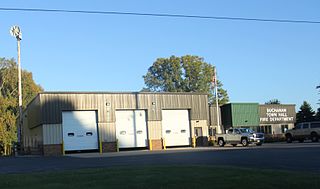
Buchanan is a town in Outagamie County, Wisconsin, United States. The population was 6,755 at the 2010 census. The unincorporated community of Darboy is located in the town.

Grand Chute is a town in Outagamie County, Wisconsin, United States. The population was 23,831 at the 2020 census. The unincorporated community of Apple Creek is partially located in the town. It was the birthplace of U.S. Senator Joseph McCarthy.

Maine is a town in Outagamie County, Wisconsin, United States. The population was 831 at the 2000 census. The unincorporated community of Leeman is located in the town.

Black Creek is a village in north-central Outagamie County, Wisconsin, United States. The population was 1,357 at the 2020 census. The village is located within the Town of Black Creek, but is governed independently. Origins of the community trace back to 1862 when it was settled by American Civil War veteran, Thomas J. Burdick and his son, Abraham. Initially, the village had been referred to as Middleburg, due to its geographical proximity to Green Bay, Shawano, and Appleton. However, the name was later changed to reflect the dark-colored creek along the outskirts of the community following village incorporation in 1904. Today, Black Creek hosts a variety of community events including the annual Family Daze celebration.

Seymour is a city in Outagamie County, Wisconsin, United States. The population was 3,451 at the 2010 census. The city is located within the Town of Seymour and the Town of Osborn.

Mackville is an unincorporated community in Outagamie County, Wisconsin, United States. It is located in the town of Center, three miles north of the City of Appleton. It is a part of the Appleton, Wisconsin Metropolitan Statistical Area, which is a part of the Fox Cities metropolitan area.

State Trunk Highway 168 was a state highway in the U.S. state of Wisconsin. It ran east–west for 5.93 miles (9.54 km) between Nichols and Seymour. Because it paralleled WIS 54 and WIS 156, the road was turned over to Outagamie County control in 2003, and is now designated as County Trunk Highway VV (CTH-VV).
Briarton is an unincorporated community in Shawano County, Wisconsin, United States, in the Town of Lessor, west of Green Bay.

Center Valley is a small unincorporated residential and agricultural community in the town of Center, Outagamie County, Wisconsin, United States. Center Valley lies 5 miles (8.0 km) north of the City of Appleton, and is served by the post office of Black Creek, which has the ZIP code 54106.
Sugar Bush is an unincorporated community located entirely within the town of Maple Creek in northwest Outagamie County, Wisconsin, United States. Sugar Bush is classified as a Class U6 Community by the USGS, being a populated place located wholly or substantially outside the boundaries of any incorporated place or CDP with a recognized authoritative common name.
Stephensville is a small unincorporated community located entirely within the town of Ellington in west-central Outagamie County, Wisconsin, United States. Stephensville is classified as a Class U6 Community by the USGS, being a populated place located wholly or substantially outside the boundaries of any incorporated place or CDP with a recognized authoritative common name.

Medina, originally Young's Corner, is an unincorporated community in the Town of Dale in southwest Outagamie County, Wisconsin, United States. It is located 3.5 miles (5.6 km) south of the village of Hortonville, 11 miles (18 km) west of Appleton, and 20 miles (32 km) northwest of Oshkosh.

Greenville is a former unincorporated community located in the village of Greenville, in Outagamie County, Wisconsin, United States. Greenville is located at the intersection of Wisconsin Highway 76 and Wisconsin Highway 15.
Hamples Corner is an unincorporated community in the town of Center, Outagamie County, Wisconsin, United States. It is situated at the intersection of County Highway O and Hample Road.
Freedom is an unincorporated community located in the town of Freedom, Outagamie County, Wisconsin, United States. Freedom is located along Wisconsin Highway 55 7.5 miles (12.1 km) north of Kaukauna. Freedom has a post office, located in Kaukauna, which uses ZIP code 54131.

Harrison is a village in Calumet and Outagamie Counties, Wisconsin, United States. The village was created on March 8, 2013, from unincorporated areas of the Town of Harrison and a portion of the Town of Buchanan: the right of way along County Trunk Highway KK in Outagamie County. The village is located in what was the northwestern part of the town of Harrison and borders Appleton and Menasha. It has a population of 11,532 and an area of 4.7 square miles (12 km2).


