Winnebago County is a county in the U.S. state of Wisconsin. As of the 2020 census, the population was 171,730. Its county seat is Oshkosh. It was named for the historic Winnebago people, a federally recognized Native American tribe now known as the Ho-Chunk Nation. Chief Oshkosh was a Menominee leader in the area. Winnebago County comprises the Oshkosh-Neenah, WI Metropolitan Statistical Area, which is included in the Appleton-Oshkosh-Neenah, WI Combined Statistical Area.

Waukesha County is a county in the U.S. state of Wisconsin. As of the 2020 United States Census, the population was 406,978, making it the third-most populous county in Wisconsin. Its county seat and largest city is Waukesha.

Itasca is a village in DuPage County, Illinois, United States. Per the 2020 census, the population was 9,543. Located approximately 25 miles northwest of downtown Chicago, Itasca is close to O'Hare International Airport, major expressways and rail transportation. Itasca is home to a country club, a resort and shares a border with Medinah's legendary golf course. The population was 9,725 at the 2020 census. BusinessWeek rated Itasca as the Best Affordable Suburb in the state of Illinois.

Watertown is a city in Dodge and Jefferson counties in the U.S. state of Wisconsin. Most of the city's population is in Jefferson County. Division Street, several blocks north of downtown, marks the county line. The population of Watertown was 22,926 at the 2020 census. Of this, 14,674 were in Jefferson County, and 8,252 were in Dodge County. Watertown is the largest city in the Watertown-Fort Atkinson micropolitan area, which also includes Johnson Creek and Jefferson.

La Crosse is a city in the U.S. state of Wisconsin and the county seat of La Crosse County. Positioned alongside the Mississippi River, La Crosse is the largest city on Wisconsin's western border. La Crosse's population as of the 2020 census was 52,680. The city forms the core of and is the principal city in the La Crosse–Onalaska Metropolitan Area, which includes all of La Crosse County and Houston County, Minnesota, with a population of 139,627.

Menomonee Falls is a village in Waukesha County, Wisconsin, United States, and is part of the Greater Milwaukee area. The population was 35,626 at the 2010 census, making it the most populous village in Wisconsin. It is the fourth largest community in Waukesha County.

Appleton is a city in Outagamie, Calumet, and Winnebago counties in the U.S. state of Wisconsin. One of the Fox Cities, it is situated on the Fox River, 30 miles (48 km) southwest of Green Bay and 100 miles (160 km) north of Milwaukee. Appleton is the county seat of Outagamie County. As of the 2020 Census it had a population of 75,644, making it the sixth largest city in Wisconsin. Appleton is a part of the Fox Cities metropolitan area, the third largest in the state behind Milwaukee and Madison.

Columbus is a city in Columbia (mostly) and Dodge Counties in the south-central part of the U.S. state of Wisconsin. The population was 5,540 at the 2020 census. All of this population resided in the Columbia County portion of the city. Columbus is located about 28 miles (45 km) northeast of Madison on the Crawfish River. The Columbia County portion of the city lies within the Madison Metropolitan Statistical Area while the Dodge County portion is a part of the Milwaukee-Waukesha-Racine CSA. Nearly all of the city is located within the town of Columbus in Columbia County, though a small portion lies within the town of Elba in Dodge County.

Platteville is the largest city in Grant County in southwestern Wisconsin. The population was 11,836 at the 2020 census, up from 11,224 at the 2010 census. Much of this growth is likely due to the enrollment increase of the University of Wisconsin–Platteville. It is the principal city of the Platteville Micropolitan Statistical area, which has an estimated population of 49,681. Platteville is located atop the greater Platte River valley in the southern Driftless Region of Wisconsin, an area known for its karst topography and rolling hills.

Burlington is a city in Racine and Walworth counties in the U.S. state of Wisconsin, with the majority of the city located in Racine County. The population of the city was 11,047 as of the 2020 census.

Oconomowoc is a city in Waukesha County, Wisconsin, United States. The name was derived from Coo-no-mo-wauk, the Potawatomi term for "waterfall." The population was 15,712 at the 2010 census. The city is partially adjacent to the Town of Oconomowoc and near the village of Oconomowoc Lake, Wisconsin.
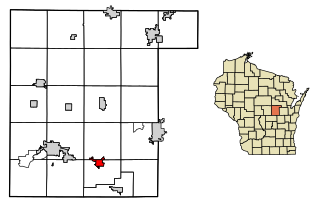
Weyauwega is a city in Waupaca County, Wisconsin, United States. The population was 1,900 at the 2010 census. The city is located mostly within the Town of Weyauwega, though it is politically independent of the town. Small portions extend north into the adjacent Town of Royalton. The city is commonly referred to as "Wega" by local residents. The name "Weyauwega" means "Here we rest" because the town's origin was a stopping/resting point between two rivers when Native Americans had to portage their canoes. A fur trader built a small building at the location, from which the town later grew.
The Fox Cities of Northeastern Wisconsin are the cities, towns and villages along the Fox River as it flows from Lake Winnebago northward into Green Bay.
Darboy is an unincorporated community in Outagamie County in the Fox Cities area of the U.S. state of Wisconsin. Located in the town of Buchanan, Darboy extends from the Calumet County line on the south, Highway CE on the north, State Park Road on the east, and Highway 441 on the west. Prior to 2013, Darboy extended south in Calumet County to Manitowoc Road in the town of Harrison; however, this part of Darboy became part of the village of Harrison upon its incorporation.

The Sheboygan Press is a daily newspaper based in Sheboygan, Wisconsin, United States. It is one of a number of newspapers in the state of Wisconsin owned by Gannett, including the Milwaukee Journal Sentinel, Green Bay Press-Gazette and Appleton's The Post-Crescent, along with the nearby Herald Times Reporter of Manitowoc. The Sheboygan Press is primarily distributed in Sheboygan County.

U.S. Highway 41 (US 41) is a north–south highway United States Numbered Highway in eastern Wisconsin. It runs from Pleasant Prairie on the Illinois border north to Marinette on the Michigan border. Most of the route is concurrent with Interstate 41 in the state, with the exception of the portion between Howard, a suburb of Green Bay, and Marinette.

WHBY is a commercial radio station licensed to Kimberly, Wisconsin, that serves the Green Bay and Appleton-Oshkosh areas. The station is owned by Woodward Communications and it airs a news/talk radio format. WHBY's studios and microwave transmitter are located on East College Avenue in Appleton.

Medina, originally Young's Corner, is an unincorporated community in the Town of Dale in southwest Outagamie County, Wisconsin, United States. It is located 3.5 miles (5.6 km) south of the village of Hortonville, 11 miles (18 km) west of Appleton, and 20 miles (32 km) northwest of Oshkosh.
Readfield is an unincorporated community in Waupaca County, Wisconsin, United States. Readfield is located on Wisconsin Highway 96 east of Fremont, in the town of Caledonia. Waupaca County Trunk Highways H and W pass through Readfield.
Fox Crossing is a village in Winnebago County, Wisconsin, United States. It was incorporated from the former Town of Menasha in 2016. The population as of the 2020 census was 18,974.