Superior, Iowa

Last updated
Superior, Iowa
Dickinson County Iowa Incorporated and Unincorporated areas Superior Highlighted.svg
Location of Superior, Iowa
Coordinates: 43°25′56″N94°56′44″W / 43.43222°N 94.94556°W / 43.43222; -94.94556 Coordinates: 43°25′56″N94°56′44″W / 43.43222°N 94.94556°W / 43.43222; -94.94556
Country Flag of the United States.svg  United States
State Flag of Iowa.svg  Iowa
County Dickinson
Area
[1]
  Total0.43 sq mi (1.11 km2)
  Land0.43 sq mi (1.11 km2)
  Water0.00 sq mi (0.00 km2)
Elevation
1,499 ft (457 m)
Population
 (2020)
  Total132
  Density307.69/sq mi (118.77/km2)
Time zone UTC-6 (Central (CST))
  Summer (DST) UTC-5 (CDT)
ZIP code
51363
Area code 712
FIPS code 19-76440
GNIS feature ID0462121

Superior is a city in Dickinson County, Iowa, United States. The population was 132 at the time of the 2020 census. [2]

Contents

History

Superior began its historic existence in 1882 when the railroad was built through the neighborhood. [3]

Geography

Superior is located at 43°25′56″N94°56′44″W / 43.43222°N 94.94556°W / 43.43222; -94.94556 (43.432156, -94.945692). [4]

According to the United States Census Bureau, the city has a total area of 0.41 square miles (1.06 km2), all land. [5]

Demographics

Historical populations
YearPop.±%
1900 187    
1910 154−17.6%
1920 200+29.9%
1930 168−16.0%
1940 230+36.9%
1950 240+4.3%
1960 190−20.8%
1970 139−26.8%
1980 188+35.3%
1990 128−31.9%
2000 142+10.9%
2010 130−8.5%
2020 132+1.5%
Source: "U.S. Census website". United States Census Bureau . Retrieved 2020-03-29. and Iowa Data Center
Source:
U.S. Decennial Census [6] [2]

2010 census

As of the census [7] of 2010, there were 130 people, 52 households, and 34 families living in the city. The population density was 317.1 inhabitants per square mile (122.4/km2). There were 60 housing units at an average density of 146.3 per square mile (56.5/km2). The racial makeup of the city was 99.2% White and 0.8% from two or more races. Hispanic or Latino of any race were 1.5% of the population.

There were 52 households, of which 26.9% had children under the age of 18 living with them, 50.0% were married couples living together, 7.7% had a female householder with no husband present, 7.7% had a male householder with no wife present, and 34.6% were non-families. 28.8% of all households were made up of individuals, and 9.6% had someone living alone who was 65 years of age or older. The average household size was 2.50 and the average family size was 2.97.

The median age in the city was 44.5 years. 22.3% of residents were under the age of 18; 6.9% were between the ages of 18 and 24; 21.5% were from 25 to 44; 33.1% were from 45 to 64; and 16.2% were 65 years of age or older. The gender makeup of the city was 53.1% male and 46.9% female.

2000 census

As of the census [8] of 2000, there were 142 people, 57 households, and 40 families living in the city. The population density was 336.0 inhabitants per square mile (129.7/km2). There were 64 housing units at an average density of 151.4 per square mile (58.5/km2). The racial makeup of the city was 99.30% White and 0.70% Asian. Hispanic or Latino of any race were 2.11% of the population.

There were 57 households, out of which 28.1% had children under the age of 18 living with them, 61.4% were married couples living together, 3.5% had a female householder with no husband present, and 29.8% were non-families. 24.6% of all households were made up of individuals, and 15.8% had someone living alone who was 65 years of age or older. The average household size was 2.49 and the average family size was 3.03.

In the city, the population was spread out, with 26.1% under the age of 18, 7.0% from 18 to 24, 26.1% from 25 to 44, 26.8% from 45 to 64, and 14.1% who were 65 years of age or older. The median age was 40 years. For every 100 females, there were 118.5 males. For every 100 females age 18 and over, there were 105.9 males.

The median income for a household in the city was $35,000, and the median income for a family was $39,250. Males had a median income of $28,333 versus $21,250 for females. The per capita income for the city was $25,486. There were none of the families and 3.3% of the population living below the poverty line, including no under eighteens and none of those over 64.

Education

Estherville–Lincoln Central Community School District operates area public schools. [9] It was established on July 1, 1997, by the merger of the Estherville and Lincoln Central school districts. [10] The northwest portion of town is served by Spirit Lake Community School District. [11]

Related Research Articles

<span class="mw-page-title-main">Emmet County, Iowa</span> County in Iowa, United States

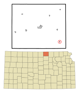
Emmet County is a county located in the U.S. state of Iowa. As of the 2020 census, the population was 9,388. The county seat is Estherville.

<span class="mw-page-title-main">St. Olaf, Iowa</span> City in Iowa, United States

St. Olaf is a city in Clayton County, Iowa, United States. The population was 106 at the time of the 2020 census, down from 136 in 2000. Swiss Valley has a large cheese packaging plant in St. Olaf.

<span class="mw-page-title-main">Dolliver, Iowa</span> City in Iowa, United States

Dolliver is a city in Emmet County, Iowa, United States. The population was 65 at the 2020 census.

<span class="mw-page-title-main">Estherville, Iowa</span> City in Iowa, United States

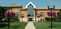
Estherville is a city in Emmet County, Iowa, United States. The population was 5,904 in the 2020 census, a decline from 6,656 at the 2000 census. It is the county seat of Emmet County. Estherville is home to the main campus of Iowa Lakes Community College.

<span class="mw-page-title-main">Gruver, Iowa</span> City in Iowa, United States

Gruver is a city in Emmet County, Iowa, United States. The population was 63 at the time of the 2020 census.

<span class="mw-page-title-main">Wallingford, Iowa</span> City in Iowa, United States

Wallingford is a city in Emmet County, Iowa, United States. The population was 197 at the 2010 census.

<span class="mw-page-title-main">Maynard, Iowa</span> City in Iowa, United States

Maynard is a city in Fayette County, Iowa, United States. The population was 476 at the time of the 2020 census.

<span class="mw-page-title-main">Radcliffe, Iowa</span> City in Iowa, United States

Radcliffe is a city in Hardin County, Iowa, United States. The population was 555 at the time of the 2020 census.

<span class="mw-page-title-main">Little Sioux, Iowa</span> City in Iowa, United States

Little Sioux is a city in Harrison County, Iowa, United States. The population was 166 at the time of the 2020 census. The city is most known for Little Sioux Scout Ranch of the Boy Scouts of America.

<span class="mw-page-title-main">Runnells, Iowa</span> City in Iowa, United States

Runnells is a city in the southeastern corner of Polk County, Iowa, United States. The population was 457 at the time of the 2020 census. It is part of the Des Moines–West Des Moines Metropolitan Statistical Area.

<span class="mw-page-title-main">Minden, Iowa</span> City in Iowa, United States

Minden is a city in Pottawattamie County, Iowa, United States. The population was 600 at the time of the 2020 census. It has possessed a post office since 1875.

<span class="mw-page-title-main">Brooklyn, Iowa</span> City in Iowa, United States

Brooklyn is a city in Poweshiek County, Iowa, United States. The population was 1,502 at the 2020 census. It is located just off U.S. Route 6 and a few miles north of Interstate 80. Near the center of town, Brooklyn boasts a large display of flags from each of the fifty states, the four branches of the military, and a smattering of other sources. The city bills itself as "Brooklyn: Community of Flags."

<span class="mw-page-title-main">Dixon, Iowa</span> City in Iowa, USA

Dixon is a city in Scott County, Iowa, United States. The population was 202 at the time of the 2020 census.

<span class="mw-page-title-main">Donahue, Iowa</span> City in Iowa, United States

Donahue is a city in Scott County, Iowa, United States. The population was 335 at the 2020 census. The city has a mayor-council form of government.

<span class="mw-page-title-main">Maysville, Iowa</span> City in Iowa, USA

Maysville is a city in Scott County, Iowa, United States. The population was 156 at the time of the 2020 census.

<span class="mw-page-title-main">New Liberty, Iowa</span> City in Iowa, USA

New Liberty is a city in Scott County, Iowa, United States. The population was 138 at the time of the 2020 census.

<span class="mw-page-title-main">Agenda, Kansas</span> City in Republic County, Kansas

Agenda is a city in Republic County, Kansas, United States. As of the 2020 census, the population of the city was 47.

<span class="mw-page-title-main">Crystal Lake Park, Missouri</span> City in Missouri, United States

Crystal Lake Park is a Missouri Class 4 city in St. Louis County, Missouri, United States. The population was 508 at the 2020 census.

<span class="mw-page-title-main">Polk, Ohio</span> Village in Ohio, United States

Polk is a village in Ashland County, Ohio, United States. The population was 336 at the 2010 census.

<span class="mw-page-title-main">Richmond, Ohio</span> Village in Ohio, United States

Richmond is a village in central Jefferson County, Ohio, United States. The population was 412 at the 2020 census. It is part of the Weirton–Steubenville metropolitan area.

References

  1. "2020 U.S. Gazetteer Files". United States Census Bureau. Retrieved March 16, 2022.
  2. 1 2 "2020 Census State Redistricting Data". census.gov. United states Census Bureau. Retrieved 12 August 2021.
  3. History of Emmet County and Dickinson County, Iowa. Pioneer Publishing Company. 1917. p.  353.
  4. "US Gazetteer files: 2010, 2000, and 1990". United States Census Bureau. 2011-02-12. Retrieved 2011-04-23.
  5. "US Gazetteer files 2010". United States Census Bureau. Archived from the original on 2012-01-25. Retrieved 2012-05-11.
  6. "Census of Population and Housing". Census.gov. Retrieved June 4, 2015.
  7. "U.S. Census website". United States Census Bureau . Retrieved 2012-05-11.
  8. "U.S. Census website". United States Census Bureau . Retrieved 2008-01-31.
  9. "Estherville-Lincoln Central" (PDF). Iowa Department of Education . Retrieved 2020-03-27.
  10. "REORGANIZATION & DISSOLUTION ACTIONS SINCE 1965-66" (PDF). Iowa Department of Education. Archived from the original (PDF) on 2019-02-09. Retrieved 2019-08-01.
  11. "SPIRIT LAKE" (PDF). Iowa department of Education . Retrieved 2020-09-15.