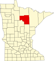
Swan River, Itasca County, Minnesota

Last updated
Swan River
USA Minnesota location map.svg
Red pog.svg
Swan River
Location of the community of Swan River
within Itasca County
Usa edcp location map.svg
Red pog.svg
Swan River
Swan River (the United States)
Coordinates: 47°05′12″N93°11′42″W / 47.08667°N 93.19500°W / 47.08667; -93.19500 Coordinates: 47°05′12″N93°11′42″W / 47.08667°N 93.19500°W / 47.08667; -93.19500
Country United States
State Minnesota
County Itasca
Elevation
1,289 ft (393 m)
Time zone UTC-6 (Central (CST))
  Summer (DST) UTC-5 (CDT)
ZIP code
55784
Area code(s) 218
GNIS feature ID652908 [1]

Swan River is an unincorporated community in southeast Itasca County, Minnesota, United States.

Contents

The community is located between Grand Rapids and Floodwood at the junction of U.S. Highway 2 (U.S. 2) and State Highway 65 (MN 65).

History

A post office called Swan River was established in 1890 and remained in operation until 1995. [2] The community took its name from the nearby Swan River. [3]

Geography

Bruce Creek flows through the community. Swan River is located along the boundary line between Sago Township and Wawina Township. The BNSF Railway passes through the community.

Nearby places include Warba, Wawina, Jacobson and Goodland. The boundary line between Itasca, Saint Louis and Aitkin counties is near Swan River.

Swan River is located 19 miles southeast of Grand Rapids, 17 miles northwest of Floodwood and 57 miles northwest of Duluth.

ZIP codes 55784 (Swan River), 55793 (Warba), and 55736 (Floodwood) all meet near Swan River.

Related Research Articles

Cedar Valley Township, St. Louis County, Minnesota Township in Minnesota, United States

Cedar Valley Township is a township in Saint Louis County, Minnesota, United States. Cedar Valley Township was named for the white cedar in the valley of the Floodwood River. The population was 195 at the 2010 census.

Floodwood Township, St. Louis County, Minnesota Township in Minnesota, United States

Floodwood Township is a township in Saint Louis County, Minnesota, United States. The population was 280 at the 2010 census. The township took its name from the Floodwood River.

Minnesota State Highway 200 (MN 200) is a 201.203-mile-long (323.805 km) highway in northwest and northeast Minnesota, which runs from North Dakota Highway 200 at the North Dakota state line near Halstad, and continues east to its eastern terminus at its intersection with U.S. Highway 2 in Northeast Aitkin County, 9-miles west of Floodwood.

Togo, Minnesota Unincorporated community in Minnesota, United States

Togo is an unincorporated community in Carpenter Township, Itasca County, Minnesota, United States.

Pengilly, Minnesota Unincorporated community in Minnesota, United States

Pengilly is an unincorporated community in eastern Itasca County, Minnesota, United States.

Goodland, Minnesota Unincorporated community in Minnesota, United States

Goodland is an unincorporated community in Goodland Township, Itasca County, Minnesota, United States.

Max, Minnesota Unincorporated community in Minnesota, United States

Max is an unincorporated community in Max Township, Itasca County, Minnesota, United States; located within the Chippewa National Forest and the Leech Lake Indian Reservation.

Mack, Minnesota Unincorporated community in Minnesota, United States

Mack is an unincorporated community in Itasca County, Minnesota, United States, located within the Chippewa National Forest. The community is located between Deer River and Talmoon, at the junction of State Highway 6 and Mac Road.

Wawina, Minnesota Unincorporated community in Minnesota, United States

Wawina is an unincorporated community in Wawina Township, Itasca County, Minnesota, United States.

Blackberry, Minnesota Unincorporated community in Minnesota, United States

Blackberry is an unincorporated community in Blackberry Township, Itasca County, Minnesota, United States.

Bergville, Minnesota Unincorporated community in Minnesota, United States

Bergville is an unincorporated community in Ardenhurst Township, Itasca County, Minnesota, United States; located within the Chippewa National Forest.

Rauch, Minnesota Unincorporated community in Minnesota, United States

Rauch is an unincorporated community in Koochiching County, Minnesota, United States.

Bramble, Minnesota Unincorporated community in Minnesota, United States

Bramble is an unincorporated community in Koochiching County, Minnesota, United States; located in the southeast corner of the county.

Dunbar, Minnesota Unincorporated community in Minnesota, United States

Dunbar is an unincorporated community in Good Hope Township, Itasca County, Minnesota, United States. The community is located northwest of Squaw Lake at the junction of Itasca County Roads 32 and 149. State Highway 46 is nearby.

Dora Lake, Minnesota Unincorporated community in Minnesota, United States

Dora Lake is an unincorporated community in Kinghurst Township, Itasca County, Minnesota, United States; located within the Chippewa National Forest. The community is located near Wirt at the junction of Itasca County Roads 29 and 145.

Grattan, Minnesota Unincorporated community in Minnesota, United States

Grattan is an unincorporated community in Grattan Township, Itasca County, Minnesota, United States.

Houpt, Minnesota Unincorporated community in Minnesota, United States

Houpt is an unincorporated community in Nore Township, Itasca County, Minnesota, United States, located in the northwest corner of the county.

Orth, Minnesota Unincorporated community in Minnesota, United States

Orth is an unincorporated community in Nore Township, Itasca County, Minnesota, United States, located in the northwestern corner of the county.

Pomroy, Minnesota Unincorporated community in Minnesota, United States

Pomroy is an unincorporated community in Pomroy Township, Itasca County, Minnesota, United States.

Martin, Minnesota Unincorporated community in Minnesota, United States

Martin is an unincorporated community in Balsam Township, Itasca County, Minnesota, United States.

References

  1. "Swan River, Minnesota". Geographic Names Information System . United States Geological Survey.
  2. "Itasca County". Jim Forte Postal History. Retrieved 12 July 2015.
  3. Upham, Warren (1920). Minnesota Geographic Names: Their Origin and Historic Significance. Minnesota Historical Society. p.  256.