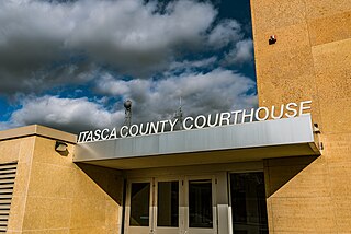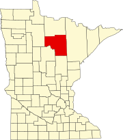
Itasca County is a county located in the Iron Range region of the U.S. state of Minnesota. As of the 2020 census, the population was 45,014. Its county seat is Grand Rapids. The county is named after Lake Itasca, which is in turn a shortened version of the Latin words veritas caput, meaning 'truth' and 'head', a reference to the source of the Mississippi River. Portions of the Bois Forte and Leech Lake Indian reservations are in the county.

Grand Rapids is a city in Itasca County, Minnesota, United States, and it is the county seat. The population was 11,126 at the 2020 census. The city is named for the 3.5-mile (5.6 km) long rapids in the Mississippi River which was the uppermost limit of practical steamboat travel during the late 19th century. Today the rapids are hidden below the dam of UPM Paper Company.
Bowstring is an unincorporated community in Bowstring Township, Itasca County, Minnesota, United States.
Makinen is an unincorporated community in St. Louis County, Minnesota, United States.
Saginaw is an unincorporated area in Saint Louis County, Minnesota, United States. Although unincorporated, Saginaw has a post office with the ZIP code 55779.
Britt is an unincorporated area in Saint Louis County, Minnesota, United States.
Silica is an unincorporated community in Saint Louis County, Minnesota, United States.
Side Lake is an unincorporated community in French Township, Saint Louis County, Minnesota, United States.
Bear River is an unincorporated community in Itasca and Saint Louis counties in the U.S. state of Minnesota.
Florenton is an unincorporated community in Wuori Township, Saint Louis County, Minnesota, United States; located near Britt.
Talmoon is an unincorporated community in Itasca County, Minnesota, United States.

U.S. Highway 169 (U.S. 169) is a major north–south highway in the U.S. state of Minnesota, connecting the Minnesota River valley with the Twin Cities and the Iron Range. Much of the route is built to expressway or freeway standards.
Soudan is an unincorporated community and census-designated place (CDP) in Breitung Township, Saint Louis County, Minnesota, United States. As of the 2010 census, its population was 446.
Swan River is an unincorporated community in southeast Itasca County, Minnesota, United States.
Goodland is an unincorporated community in Goodland Township, Itasca County, Minnesota, United States.
Max is an unincorporated community in Max Township, Itasca County, Minnesota, United States; located within the Chippewa National Forest and the Leech Lake Indian Reservation.
Wawina is an unincorporated community in Wawina Township, Itasca County, Minnesota, United States.
Blackberry is an unincorporated community in Blackberry Township, Itasca County, Minnesota, United States.
Bergville is an unincorporated community in Ardenhurst Township, Itasca County, Minnesota, United States; located within the Chippewa National Forest.


