Related Research Articles

Hillcrest is an unincorporated place in central Warren County, Ohio, United States on U.S. Route 42 about halfway between Mason, 4 miles to the southwest, and Lebanon, 3 mi (5 km) to the northeast. The community straddles the township line between Turtlecreek and Union Townships. The former Cincinnati, Lebanon and Northern Railway runs just east of the community and once had a stop here called "Turtlecreek". It is in the Lebanon City School District and is served by the Lebanon telephone exchange and post office.
Liberty is an unincorporated community in Montgomery County, in the U.S. state of Ohio.

Reno is a census-designated place in southern Marietta Township, Washington County, Ohio, United States. Although it is unincorporated, it has a post office, with the ZIP code of 45773. It is located on the Ohio River a short distance above the county seat of Marietta. State Route 7 forms its main street.

Fairhaven is an unincorporated community in eastern Israel Township, Preble County, Ohio, United States. It lies along State Route 177 at its intersection with Israel-Somers Road. Four Mile Creek, which feeds into Acton Lake in southern Preble County, runs on the western edge of Fairhaven. It is located 10½ miles southwest of Eaton, the county seat of Preble County. The community is part of the Dayton Metropolitan Statistical Area. Fairhaven Church and Fairhaven Community Church are both located in Fairhaven along State Route 177. Fairhaven Community Church hosts a free annual Dinner Drama for the community. Fairhaven is home to the historic Bunker Hill house, a stop along the Underground Railroad.

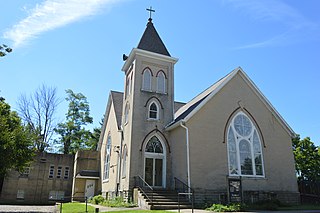
Pyrmont is an unincorporated community in northwestern Perry Township, Montgomery County, Ohio, United States. It centers at the intersection of Brookville–Pyrmont Pike and Sulphur Springs Road, extending to the intersection of Brookville–Pyrmont Pike and Providence Pike. Located in the far west of the county, it lies several miles from the city of Dayton; the nearest city is Brookville, 3 miles to the northeast. Pyrmont is a part of the Brookville Local School District. Pyrmont, which was on a stagecoach route, was a busy town before Interstate 70 was built near Brookville.

Royalton is an unincorporated community in northern Amanda Township, Fairfield County, Ohio, United States.
Melbern is a small unincorporated community in western Center Township, Williams County, Ohio, United States. It is situated on County Road 9 south of County Road D.
Sebastian is an unincorporated community in northern Marion Township, Mercer County, Ohio, United States. Its elevation is 932 feet (284 m), and it is located at 40°26′39″N84°31′0″W. Located at the intersection of Sebastian Road and County Road 716-A, the community lies south of the city of Celina, the county seat of Mercer County, and nearly 2 miles (3.2 km) northwest of the village of Chickasaw.
Little York is an unincorporated community in Butler Township, Montgomery County, Ohio, United States. It is located on the east bank of the Stillwater River, at the intersection of Little York Road and Meeker Road, not far from the intersection of I-70 and Ohio State Route 48.
Columbia Center is a historic neighborhood of the city of Pataskala in Licking County, Ohio, United States. It lies slightly more than 1 mile (1.6 km) west of Pataskala's downtown.
Rochester is an unincorporated community in Noble County, in the U.S. state of Ohio.
Airhill is an unincorporated community in Montgomery County, in the U.S. state of Ohio.
Amity is an unincorporated community in Montgomery County, in the U.S. state of Ohio.
Bachman is an unincorporated community in Montgomery County, in the U.S. state of Ohio.
Dodson is an unincorporated community in Montgomery County, in the U.S. state of Ohio.
Harries is a historic community in Montgomery County, in the U.S. state of Ohio.
Kinsey is a historic community in Montgomery County, in the U.S. state of Ohio; its location, 39°51′14″N84°17′34″W, makes it a neighborhood of Englewood.
Spanker is an unincorporated community in Montgomery County, in the U.S. state of Ohio.
Tadmor is an extinct town in Montgomery County, in the U.S. state of Ohio. Its location, 39°53′45″N84°9′55″W, is now within the Vandalia city limits.
Arlington is an unincorporated community in Montgomery County, in the U.S. state of Ohio.
References
- ↑ DeLorme. Ohio Atlas & Gazetteer. 7th ed. Yarmouth: DeLorme, 2004, 65. ISBN 0-89933-281-1.
- ↑ "Montgomery County". Jim Forte Postal History. Retrieved 23 January 2016.
- ↑ Drury, Augustus Waldo (1909). History of the City of Dayton and Montgomery County, Ohio, Volume 1. S. J. Clarke Publishing Company. p. 921.
Municipalities and communities of Montgomery County, Ohio, United States | ||
|---|---|---|
| Cities |  | |
| Villages | ||
| Townships | ||
| CDPs | ||
| Unincorporated communities | ||
| Ghost towns | ||
| Footnotes | ‡This populated place also has portions in an adjacent county or counties | |
Coordinates: 39°49′51″N84°17′34″W / 39.83083°N 84.29278°W
| This Montgomery County, Ohio state location article is a stub. You can help Wikipedia by expanding it. |