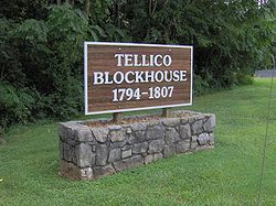
The Tellico Blockhouse was an early American outpost located along the Little Tennessee River in what developed as Vonore, Monroe County, Tennessee. Completed in 1794, the blockhouse was a US military outpost that operated until 1807; the garrison was intended to keep peace between the nearby Overhill Cherokee towns and encroaching early Euro-American pioneers in the area in the wake of the Cherokee–American wars.
The Tellico Blockhouse was the site where several treaties were negotiated between the United States and the Cherokee, by which the latter ceded large portions of land in present-day Tennessee and Georgia in order to try to gain peace. The US provided various financial incentives for these actions. During this period, the blockhouse was the site of official liaisons between the United States government and the Cherokee.
It was designated as the Tellico Blockhouse State Historic Area and listed in 1975 on the National Register of Historic Places. It is administered by staff of the nearby Fort Loudoun State Historic Area.
Geographic setting
The Tellico Blockhouse site is located at the junction of Nine Mile Creek and the Little Tennessee River (now Tellico Lake), between Maryville and Vonore. U.S. Route 411 passes nearby. Fort Loudoun was located just across the river to the west, but it was in ruins by the time the blockhouse was built. The Tellico Blockhouse originally stood on a high bluff overlooking the Little Tennessee valley.[1]
The Overhill towns of Chota and Great Tellico were within a day's journey to the south. The river town of Morganton (then known as "Portville") was within walking distance. Knoxville was thirty miles downstream on the Little Tennessee River and then upstream on the Tennessee River to the north. As there were no bridges built to span the Little Tennessee until the late 19th century, blockhouse officials crossed at Niles Ferry.[1]
This ferry site was later used for the ends of the modern US-411 bridge. In 1979 the Tellico Dam was completed on the Little Tennessee River. The impoundment of the river, creating Tellico Lake, pushed the present shoreline to within a few meters of the blockhouse site.
Historically, the Tellico Blockhouse was the starting point of the Old Federal Road, which connected Knoxville to Cherokee settlements in Georgia.[1] It was also the start of the Unicoi Turnpike, a Cherokee trading path that connected to North Carolina and north Georgia.[2]
History
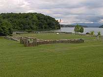
The Tellico Blockhouse site, at the confluence of Nine Mile Creek (left) and the Little Tennessee River (right)
During the second half of the 18th century, the number of Anglo-European settlers into East Tennessee rapidly increased. They came into conflict with the Cherokee, whose territory this had been for centuries. Armed confrontations developed, as the Cherokee raided the settlements and sometimes killed settlers, conducting ritual scalpings. The settlers formed independent militias and carried out reprisal attacks. This violence reached a climax in 1793, when the Cherokee attacked Henry's Station in Blount County. The pioneers responded by crossing Chilhowee Mountain and sacking the Cherokee village of Tallassee.[3] Even as the Cherokee chief Hanging Maw was meeting with Governor William Blount to discuss bringing peace to the area, the chief's delegation was attacked by a band of settlers, who killed several Cherokee headmen.[4]
Hanging Maw convinced Blount to construct a fort in the vicinity of the Overhill towns in order to suppress violence. The chief donated the land.[4] The Tellico Blockhouse was completed and garrisoned by federal troops from Knoxville in 1794. John McKee, a surveyor in the area, was appointed as the first Tellico Indian Agent.[5] He was to act as the official liaison between the United States government and the Cherokee Nation.
The blockhouse was a crude fort built from earthworks and timber.[6] Sawed planking was shipped upstream from Knoxville.[7]
According to historian J. G. M. Ramsey in his history originally published in 1853, it was:
...a strong work, of considerable size, with a projection on each square, furnished with port-holes, and calculated to stand a siege by an enemy provided with small arms only.[8]
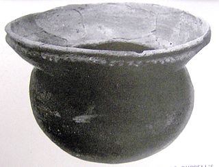
Plate uncovered during excavations at the Tellico Blockhouse site
The original blockhouse was approximately 120x100 feet, enclosed by a defensive palisade approximately 16 feet high. The gate was on the north wall, with the captain's quarters and guardhouse just inside the gate. The original enclosure contained two barracks, a well, and parade grounds. A watchtower stood at the northeast corner.[9]
In 1795, Congress passed the Factory Act, which sought to improve relations with American Indians by setting up official trading posts and teaching the natives agricultural and mechanical techniques. To implement this, McKee's successor, Silas Dinsmoor, expanded the Tellico Blockhouse to nearly double its original size to incorporate a civilian half. This new section, separated by a wall from the military section, contained lodging areas for travelers and delegates and a two-story building known as the Tellico Factory. Along with a trading post where European-American tools and finished goods were traded for Native American furs and raw materials, the factory included a section where members of the new Cherokee Nation could learn mechanical arts, and spinning and weaving cloth.[9][10]
In April 1797, the exposure of the so-called "Blount Conspiracy"—in which Senator William Blount attempted to convince Britain to attack and capture the Spanish-controlled port of New Orleans—began at the Tellico Blockhouse. James Carey, a merchant whom Blount had attempted to recruit, gave a letter from Blount detailing the conspiracy to James Byers, a government trader at the Blockhouse. Byers turned the letter over to Colonel David Henley (a foe of Blount) in Knoxville, and Henley delivered it to Secretary of State Timothy Pickering.[11] Blount was eventually expelled from the Senate based in part on this letter.[12]
In December 1797, one of the first recorded Christmas celebrations in Tennessee occurred among the garrison at the Tellico Blockhouse to celebrate the Little Tennessee River freezing over. On the night of December 25, Dinsmoor and the federal garrison held a dinner party on the ice.
This was later described by Ramsey from a contemporary news article:
On the 25th, a Christmas dinner was given upon the ice, by the Federal officers, at Tellico Block-house, to a large company of gentlemen and ladies. "Contiguous to the place of entertainment, two quarters of a bear were barbecued, where the ice was found to be, in thickness, sufficient to bare fire enough to have roasted an ox, without being materially weakened by the heat."[13]
Foundation of the Tellico Factory
The Tellico Blockhouse likely had its peak of activity around 1799, due to its location along the Old Federal Road. That same year, Louis-Philippe, Duke of Orleans and later king of France, paid a visit to the blockhouse.[14] In 1800, several Cherokee leaders convened at the blockhouse to debate whether or not to allow missionaries into Cherokee towns. The Cherokee hoped the missionaries would provide educational services to their children.[15]
In the early 19th century, the Cherokee slowly migrated south to the Hiwassee River and deeper into Georgia, trying to escape the encroachment of European Americans. As the Overhill towns along the Little Tennessee River began to disperse, the Tellico Blockhouse's influence started to wane.[5] In 1801, Colonel Return J. Meigs took over as Cherokee agent. This appointment effectively moved the agency to Fort Southwest Point (modern Kingston, Tennessee), where Meigs was based. In 1805, the last Tellico treaty called for the removal of the blockhouse garrison south to the Hiwassee River area.[16]
When archeologists from the University of Tennessee conducted excavations at the Tellico Blockhouse site in the 1970s, they located the fort's foundations and a number of artifacts. Due to a lack of records, officials concluded they would not attempt a reconstruction of the blockhouse. They directed the reinforcement of foundations with authentic fill material so visitors can see the fort's layout.[14] Short posts were erected to show the position of the blockhouse walls, and interpretive signs were placed at the site to explain the fort's brief history.
The site is preserved as a State Historic Area, listed on the National Register of Historic Places, and managed by staff of the Fort Loudoun State Historic Area. Some of the artifacts recovered during the excavation are displayed at the nearby Fort Loudoun museum and the Frank H. McClung Museum in Knoxville.
Several treaties between the United States and the Cherokee Nation were negotiated at the Tellico Blockhouse:
A treaty signed on November 8, 1794 marked the end of the Cherokee–American wars. Cherokee chiefs Hanging Maw (representing the Upper Cherokee) and Colonel John Watt (representing the Lower Cherokee, or "Chickamauga") met with Governor William Blount to negotiate this. All sides agreed to recognize boundaries set forth in previous treaties.[17]
The 'First Treaty of Tellico', also known as the Treaty with the Cherokee, negotiated in 1797 and signed on October 2, 1798, was intended to compensate the Cherokee for land to be ceded to illegal settlers ("squatters"). In exchange for ceding land, the Cherokee received various financial incentives and a guarantee of the right of the Cherokee Nation to "exist forever."[18] The U.S. negotiators, acting on instructions from Governor John Sevier, included James Robertson, Lachlan McIntosh, Thomas Butler, and James White.[19]
The 'Second Treaty of Tellico', signed on October 24, 1804, brought the Wafford settlements in northern Georgia under U.S. dominion. The Cherokee received various financial incentives to cede these lands to the US. Colonel Return J. Meigs negotiated the treaty for the United States.[20]
The 'Third Treaty of Tellico', signed on October 25, 1805, and the 'Fourth Treaty of Tellico', signed two days later on October 27, brought the land between the Cumberland River and Duck River (i.e., most of the Cumberland Plateau) under U.S. dominion by Cherokee cessions. The goal of the U.S. was to connect East Tennessee with Nashville. Both treaties were negotiated for the United States by Colonel Return J. Meigs. Two of the Cherokee negotiators, Doublehead and Tollunteeskee, were later criticized for including "secret articles" that allowed for personal incentives.[20]
Monroe County is a county located on the eastern border of the U.S. state of Tennessee. As of the 2020 census, the population was 46,250. Its county seat is Madisonville, and its largest city is Sweetwater.
Vonore is a town in Monroe County, Tennessee, which is located on the southeast border of the state. The population was 1,574 as of the 2020 census. The city hall, library, community center, police department, and fire department are located on Church Street.
The Little Tennessee River is a 135-mile (217 km) tributary of the Tennessee River that flows through the Blue Ridge Mountains from Georgia, into North Carolina, and then into Tennessee, in the southeastern United States. It drains portions of three national forests— Chattahoochee, Nantahala, and Cherokee— and provides the southwestern boundary of the Great Smoky Mountains National Park.
Tuskegee was an Overhill Cherokee town located along the lower Little Tennessee River in what is now Monroe County, Tennessee, United States. The town developed in the late 1750s alongside Fort Loudoun, and was inhabited until the late 1770s. It was forcibly evacuated and probably burned during the Cherokee–American wars.
Chota is a historic Overhill Cherokee town site in Monroe County, Tennessee, in the southeastern United States. Developing after nearby Tanasi, Chota was the most important of the Overhill towns from the late 1740s until 1788. It replaced Tanasi as the de facto capital, or 'mother town' of the Cherokee people.
Fort Loudoun was a British fort located in what is now Monroe County, Tennessee. Constructed from 1756 until 1757 to help garner Cherokee support for the British at the outset of the French and Indian War, the fort was one of the first significant British outposts west of the Appalachian Mountains. The fort was designed by John William Gerard de Brahm, while its construction was supervised by Captain Raymond Demeré; the fort's garrison was commanded by Demeré's brother, Paul Demeré. It was named for the Earl of Loudoun, the commander of British forces in North America at the time.
The Anglo-Cherokee War, was also known from the Anglo-European perspective as the Cherokee War, the Cherokee Uprising, or the Cherokee Rebellion. The war was a conflict between British forces in North America and Cherokee bands during the French and Indian War.
Icehouse Bottom is a prehistoric Native American site in Monroe County, Tennessee, located on the Little Tennessee River in the southeastern United States. Native Americans were using the site as a semi-permanent hunting camp as early as 7500 BC, making it one of the oldest-known habitation areas in Tennessee. Analysis of the site's Woodland period artifacts shows evidence of an extensive trade network that reached to indigenous peoples in Georgia, North Carolina, and Ohio. This was later an area of known Cherokee settlements, the people encountered by Anglo-European settlers in the 18th and 19th centuries.
The Cherokee–American wars, also known as the Chickamauga Wars, were a series of raids, campaigns, ambushes, minor skirmishes, and several full-scale frontier battles in the Old Southwest from 1776 to 1794 between the Cherokee and American settlers on the frontier. Most of the events took place in the Upper South region. While the fighting stretched across the entire period, there were extended periods with little or no action.
Morganton was a community that developed on the Little Tennessee River in Loudon County, Tennessee, in the southeastern United States. It was located 13.7 miles (22.0 km) above the mouth of the river at its confluence with Bakers Creek, flowing westward from Maryville. During its heyday in the 19th century, Morganton thrived as a flatboat port and regional business center. An important ferry operated at Morganton for nearly 170 years providing service across the river. The abandoned townsite was submerged in the late 20th century by creation of Tellico Lake, part of the Tellico Dam hydroelectric project completed in 1979 by the Tennessee Valley Authority (TVA).
Overhill Cherokee was the term for the Cherokee people located in their historic settlements in what is now the U.S. state of Tennessee in the Southeastern United States, on the western side of the Appalachian Mountains. This name was used by 18th-century European traders and explorers from British colonies along the Atlantic coast, as they had to cross the mountains to reach these settlements.
Toqua was a prehistoric and historic Native American site in Monroe County, Tennessee, located in the Southeastern Woodlands. Toqua was the site of a substantial ancestral town that thrived during the Mississippian period. Toqua had a large earthwork 25-foot (7.6 m) platform mound built by the town's Mississippian-era inhabitants, in addition to a second, smaller mound. The site's Mississippian occupation may have been recorded by the Spanish as the village of Tali, which was documented in 1540 by the Hernando de Soto expedition. It was later known as the Overhill Cherokee town Toqua, and this name was applied to the archeological site.
Tomotley is a prehistoric and historic Native American site along the lower Little Tennessee River in Monroe County, Tennessee, in the southeastern United States. Occupied as early as the Archaic period, the Tomotley site was occupied particularly during the Mississippian period, which was likely when its earthwork platform mounds were built. It was also occupied during the eighteenth century as a Cherokee town. It revealed an unexpected style: an octagonal townhouse and square or rectangular residences. In the Overhill period, Cherokee townhouses found in the Carolinas in the same period were circular in design, with,
Fort Southwest Point was a federal frontier outpost at what is now Kingston, Tennessee, in the Southeastern United States. Constructed in 1797 and garrisoned by federal soldiers until 1811, the fort served as a major point of interaction between the Cherokee and the United States government as well as a way station for early migrants travelling between Knoxville and Nashville.
Citico is a prehistoric and historic Native American site in Monroe County, Tennessee, in the southeastern United States. The site's namesake Cherokee village was the largest of the Overhill towns, housing an estimated Indian population of 1,000 by the mid-18th century. The Mississippian village that preceded the site's Cherokee occupation is believed to have been the village of "Satapo" visited by the Juan Pardo expedition in 1567.
Chilhowee was a prehistoric and historic Native American site in present-day Blount and Monroe counties in Tennessee, in what were the Southeastern Woodlands. Although now submerged by the Chilhowee Lake impoundment of the Little Tennessee River, the Chilhowee site was home to a substantial 18th-century Overhill Cherokee town. It may have been the site of the older Creek village "Chalahume" visited by Spanish explorer Juan Pardo in 1567. The Cherokee later pushed the Muscogee Creek out of this area.
Tallassee is a prehistoric and historic Native American site in present-day Blount and Monroe counties, Tennessee in the southeastern United States. Tallassee was the southernmost of a string of Overhill Cherokee towns that existed along the lower Little Tennessee River on the west side of the Appalachian Mountains in the 18th century. Although Tallassee receives scant attention in primary historical accounts, it is one of the few Overhill towns to be shown on every major 18th-century map of the Little Tennessee Valley.
Doublehead (1744–1807) or Incalatanga, was one of the most feared warriors of the Cherokee during the Cherokee–American wars. Following the peace treaty at the Tellico Blockhouse in 1794, he served as one of the leaders of the Chickamauga Cherokee, and he was chosen as the leader of Chickamauga in 1802.
John Watts, also known as Young Tassel, was one of the leaders of the Chickamauga Cherokee during the Cherokee–American wars. Watts became particularly active in the fighting after frontiersmen murdered his uncle, Old Tassel Carpenter (1708–1788), in 1788, while he traveled with Cherokee delegates to a peace conference.
Bussell Island, formerly Lenoir Island, is an island located at the mouth of the Little Tennessee River, at its confluence with the Tennessee River in Loudon County, near the U.S. city of Lenoir City, Tennessee. The island was inhabited by various Native American cultures for thousands of years before the arrival of early European explorers. The Tellico Dam and a recreational area occupy part of the island. Part of the island was added in 1978 to the National Register of Historic Places for its archaeological potential.
References
1 2 3 Brewer, Alberta; Carson Brewer (1975). Valley so Wild: A Folk History. Knoxville: East Tennessee Historical Society. p.96. OCLC2048478.
1 2 Rozema, Vicki (1995). Footsteps of the Cherokees: A Guide to the Eastern Homelands of the Cherokee Nation. Winston-Salem: John F. Blair. p.130. ISBN0-89587-133-5.
↑ Smith, Gerald L. (2006). "Early Settlement Shelters and Forts". In Rudy Abramson and Jean Haskell (ed.). Encyclopedia of Appalachia. Knoxville: University of Tennessee Press. ISBN1-57233-456-8.
↑ Smith, Gerald L. & Solomon K., "Lumber Settlements" in Encyclopedia of Appalachia.
↑ Ramsey, J.G.M. (1999). The Annals of Tennessee to the End of the Eighteenth Century (reprint). Johnson City: Overmountain Press. p.564. ISBN1-57072-091-6.
1 2 Interpretive signs at the Tellico Blockhouse State Historic Site, November 2006.
↑ Rozema, Footsteps of the Cherokees, pp. 36–37, 130.
↑ Mooney, James (1972). Myths of the Cherokee and Sacred Formulas of the Cherokees (first published in two volumes, in 1900 and 1891, respectively). Nashville: C. Elder-Bookseller. p.84. OCLC393753.
↑ Van West, Carroll (1998). "The Tellico Blockhouse". The Tennessee Encyclopedia of History and Culture. Retrieved 2007-06-25.
This page is based on this Wikipedia article Text is available under the CC BY-SA 4.0 license; additional terms may apply. Images, videos and audio are available under their respective licenses.