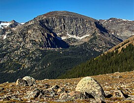
Rocky Mountain National Park is an American national park located approximately 55 mi (89 km) northwest of Denver in north-central Colorado, within the Front Range of the Rocky Mountains. The park is situated between the towns of Estes Park to the east and Grand Lake to the west. The eastern and western slopes of the Continental Divide run directly through the center of the park with the headwaters of the Colorado River located in the park's northwestern region. The main features of the park include mountains, alpine lakes and a wide variety of wildlife within various climates and environments, from wooded forests to mountain tundra.
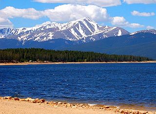
Mount Elbert is the highest summit of the Rocky Mountains, the highest point in the U.S. state of Colorado, and the second-highest summit in the contiguous United States. The ultra-prominent 14,440-foot (4401.2 m) fourteener is the highest peak in the Sawatch Range, as well as the highest point in the entire Mississippi River drainage basin. Mount Elbert is located in San Isabel National Forest, 12.1 miles (19.4 km) southwest of the City of Leadville in Lake County, Colorado.

White Mountain Peak, at 14,252-foot (4,344 m), is the highest peak in the White Mountains of California, the highest peak in Mono County, and the third highest peak in the state after Mount Whitney and Mount Williamson.

Capitol Peak is a high and prominent mountain summit in the Elk Mountains range of the Rocky Mountains of North America. It is the 52nd highest mountain in North America. The 14,137-foot (4,309 m) fourteener is located in the Maroon Bells-Snowmass Wilderness of White River National Forest, 8.7 miles (14.0 km) east by south of the community of Redstone in Pitkin County, Colorado, United States.

Arizona is a landlocked state situated in the southwestern region of the United States of America. It has a vast and diverse geography famous for its deep canyons, high- and low-elevation deserts, numerous natural rock formations, and volcanic mountain ranges. Arizona shares land borders with Utah to the north, the Mexican state of Sonora to the south, New Mexico to the east, and Nevada to the northwest, as well as water borders with California and the Mexican state of Baja California to the southwest along the Colorado River. Arizona is also one of the Four Corners states and is diagonally adjacent to Colorado.

Sugarite Canyon State Park is a state park of New Mexico, United States, featuring a historic early-20th century coal-mining camp and natural scenery at the border of the Rocky Mountains and the Great Plains. The park is located on the Colorado–New Mexico state line 6 miles (9.7 km) northeast of Raton, New Mexico.
Meridian Peak is a mountain summit in the Gore Range of the Rocky Mountains of North America. The 12,432-foot (3,789 m) peak is located in the Eagles Nest Wilderness, 9.0 miles (14.5 km) north by west of the Town of Vail, Colorado, United States, on the drainage divide separating White River National Forest and Eagle County from Arapaho National Forest and Summit County.

Red and White Mountain is a remote 12,816-foot-elevation mountain summit located on the crest of the Sierra Nevada mountain range in northern California, United States. It is situated in the John Muir Wilderness on the shared boundary of Sierra National Forest with Inyo National Forest, and along the common border of Fresno County with Mono County. It is eight miles northeast of Lake Thomas A Edison, and approximately 13 miles (21 km) southeast of the community of Mammoth Lakes. The nearest higher neighbor is Red Slate Mountain, 2 miles (3.2 km) to the north-northwest.

Mount Garfield is a 13,074-foot-elevation (3,985-meter) mountain summit located in San Juan County, Colorado, United States. It is situated eight miles south of the community of Silverton, in the Weminuche Wilderness, on land managed by San Juan National Forest. It is part of the San Juan Mountains range which is a subset of the Rocky Mountains of North America. Precipitation runoff from the mountain drains into tributaries of the Animas River. The peak can be seen from U.S. Route 550 and the Durango and Silverton Narrow Gauge Railroad. Topographic relief is significant as the west aspect rises over 4,300 feet above the river and railway in approximately one mile. It is set six miles west of the Continental Divide, one mile west of Electric Peak, and three miles east-southeast of Snowdon Peak.

Snowdon Peak is a 13,077-foot-elevation (3,986-meter) mountain summit located in San Juan County, Colorado, United States. It is situated seven miles south of the community of Silverton, in the Weminuche Wilderness, on land managed by San Juan National Forest. It is part of the San Juan Mountains range which is a subset of the Rocky Mountains of North America, and is set nine miles west of the Continental Divide. Topographic relief is significant as the east aspect rises 4,300 feet above the Animas River in approximately 1.5 mile. Neighbors include Mount Garfield three miles to the east-southeast, and Twilight Peak, which is the nearest higher peak, 3.7 miles to the south-southwest. This mountain can be seen from U.S. Route 550. The mountain is named after Snowdon, the highest mountain in Wales.

Electric Peak is a 13,292-foot-elevation (4,051-meter) mountain summit located in San Juan County, Colorado, United States. It is situated eight miles south of the community of Silverton, in the Weminuche Wilderness, on land managed by San Juan National Forest. It is part of the Needle Mountains which are a subset of the San Juan Mountains, which in turn is a subset of the Rocky Mountains. Precipitation runoff from the mountain drains into tributaries of the Animas River. The peak can be seen from U.S. Route 550 and the Durango and Silverton Narrow Gauge Railroad. Topographic relief is significant as the west aspect rises over 4,500 feet above the river and railway in approximately two miles. It is set five miles west of the Continental Divide, and one mile east of Mount Garfield. The mountain's name, which has been officially adopted by the United States Board on Geographic Names, was in use before 1906 when Henry Gannett published it in the Gazetteer of Colorado.

Mount Emma is a 13,581-foot-elevation (4,139-meter) mountain summit located in San Miguel County of Colorado, United States. It is situated three miles north of the community of Telluride, on the south side of Yankee Boy Basin, in the Uncompahgre National Forest. It is part of the Sneffels Range which is a subset of the San Juan Mountains, which in turn is part of the Rocky Mountains. Mount Emma is situated west of the Continental Divide, two miles south of Mount Sneffels, and 0.8 mile south of Gilpin Peak, the nearest higher neighbor. Emma ranks as the 197th-highest peak in Colorado, and the 10th-highest in the Sneffels Range. Topographic relief is significant as the south aspect rises 4,830 feet above Telluride in approximately three miles. An ascent of Mt. Emma is a difficult climb with 2,180 feet of elevation gain covering three miles from Yankee Boy Basin, or 4,836 feet of elevation gain from Telluride. This mountain's name was officially adopted by the U.S. Board on Geographic Names.
Coxcomb Peak is a 13,656-foot-elevation (4,162-meter) mountain summit located on the common boundary of Hinsdale County and Ouray County, in Colorado, United States. It is situated nine miles northeast of the community of Ouray, in the Uncompahgre Wilderness, on land managed by Uncompahgre National Forest. It is part of the San Juan Mountains which are a subset of the Rocky Mountains, and is situated west of the Continental Divide. Coxcomb ranks as the 171st-highest peak in Colorado, and topographic relief is significant as the south aspect rises 2,000 feet above Wetterhorn Basin in approximately one mile, and 4,400 feet above Cow Creek in three miles. Neighbors include Precipice Peak 2.7 miles to the north, Redcliff one-half mile north, Matterhorn Peak 2.3 miles to the east-southeast, and nearest higher neighbor Wetterhorn Peak 1.8 mile to the southeast. The mountain's descriptive name, which has been officially adopted by the United States Board on Geographic Names, was in use since at least 1906 when Henry Gannett published it in the Gazetteer of Colorado.
Engineer Mountain is a 12,968-foot-elevation (3,953-meter) mountain summit located in San Juan County, Colorado, United States. It is part of the San Juan Mountains range which is a subset of the Rocky Mountains, and is west of the Continental Divide. Engineer Mountain is a prominent landmark set 1.5 mile immediately west of Coal Bank Pass, and is visible from multiple viewpoints along Highway 550, making it one of the most photographed mountains in the San Juans. It is situated 11 miles southwest of the community of Silverton, on land managed by San Juan National Forest. Topographic relief is significant as the southwest aspect rises 3,800 feet above Cascade Creek in approximately two miles. Neighbors include Snowdon Peak seven miles to the east, and Twilight Peak, five miles to the southeast.

Ajax Peak is a 12,785-foot-elevation (3,897-meter) mountain summit located in San Miguel County of southwest Colorado, United States. It is situated on land managed by Uncompahgre National Forest, and is the iconic landmark visible three miles east of the community of Telluride. Ajax is set immediately south of Savage Basin and the ghost town of Tomboy, one mile southwest of Chicago Peak, and one mile west of Telluride Peak. It is also immediately northeast of Bridal Veil Falls, Colorado's highest waterfall at 365-feet high. It is part of the San Juan Mountains which are a subset of the Rocky Mountains. Topographic relief is significant as the west aspect rises 3,800 feet above the box canyon in approximately one mile. The old mill town of Pandora at the base of Ajax Peak was hit by snow slides each winter, and one particularly bad event in 1884 came over the Ajax Mine and wrecked the mills.

Pilot Knob is a 13,738-foot-elevation (4,187-meter) mountain summit located on the shared boundary of San Juan County with San Miguel County, in southwest Colorado, United States. It is situated nine miles west of the community of Silverton, on land managed by San Juan National Forest and Uncompahgre National Forest. Pilot Knob is part of the San Juan Mountains which are a subset of the Rocky Mountains, and is west of the Continental Divide. It ranks as the 132nd-highest peak in Colorado, and topographic relief is significant as the west aspect rises 4,000 feet above Trout Lake in three miles. Neighbors include Ulysses S Grant Peak 1.5 mile to the northeast, and Golden Horn one-half mile to the southeast. The mountain's name, which has been officially adopted by the United States Board on Geographic Names, was listed by Henry Gannett when he published A Gazetteer of Colorado in 1906. The peak is considered one of the most difficult to climb in Colorado because of its poor quality volcanic rock.

Mount Chapin is a 12,454-foot-elevation (3,796-meter) mountain summit located in Rocky Mountain National Park, in Larimer County, of Colorado, United States. It is situated 11 miles west-northwest of the community of Estes Park, one mile east of Chapin Pass, and six miles east of the Continental Divide. Mount Chapin is part of the Mummy Range which is a subset of the Rocky Mountains. Topographic relief is significant as the south aspect rises 2,700 feet above Fall River in less than one mile. Neighbors include Mount Chiquita and Ypsilon Mountain to the immediate northeast, and the park's Alpine Visitor Center is three miles to the west.

Hayden Spire is a 12,480+ foot elevation (3,800 meter) pillar located in Rocky Mountain National Park, in Larimer County, Colorado, United States. It is situated 12 miles west of the community of Estes Park in Hayden Gorge, along a short spur on the Continental Divide. Hayden Spire is part of the Front Range which is a subset of the Rocky Mountains. It is the highest tower in a cluster of spires which can be viewed from Forest Canyon Overlook along the Trail Ridge Road. Topographic relief is significant as the north aspect rises 2,100 feet above Hayden Gulch in one-half mile. Neighbors include Terra Tomah Mountain two miles to the north, and Mount Julian 1.8 mile to the northwest.

Kettle Peak is a mountain with a summit elevation of 11,010 feet (3,356 m) located in the Sierra Nevada mountain range, in Mono County of northern California, United States. The summit is set in the Hoover Wilderness on land managed by Humboldt–Toiyabe National Forest, and is less than one-half mile outside the boundary of Yosemite National Park. The peak is situated approximately three miles southwest of Twin Lakes, three miles south of Victoria Peak, 2.9 miles northeast of Crown Point, and 3.1 miles northwest of Matterhorn Peak. Topographic relief is significant as the west aspect rises over 2,600 feet (792 meters) above Robinson Creek in one mile.