Texas State Highway 154

Last updated

Texas 154.svg

State Highway 154

Texas State Highway 154
SH 154 highlighted in red
Route information
Maintained by TxDOT
Length104.59 mi [1] [lower-alpha 1]  (168.32 km)
Existedby 1931–present
Major junctions
Northwest endTexas 24.svg SH 24 in Cooper
Major intersections
Southeast endTexas Loop 390.svg Loop 390 in Marshall
Location
Country United States
State Texas
Highway system
Texas 153.svg SH 153 Texas 155.svg SH 155
SH 154 as Tyler Street in Gilmer Gilmer September 2018 20 (W Tyler Street).jpg
SH 154 as Tyler Street in Gilmer

State Highway 154 (SH 154) is a state highway that runs from Cooper to Marshall in northeast Texas.

Contents

History

The route was designated originally on March 19, 1930 between Cooper and Quitman as a renumbering of SH 37A. A proposed extension west to Ladonia was added on February 8, 1933. [2] On July 15, 1935, the extension was cancelled. [3] On December 22, 1936, the extension of SH 154 to Ladonia was restored. [4] On August 4, 1937, this section to Cooper was renumbered as new SH 247, and SH 154 was rerouted north over old SH 247 to northeast of Cooper. [5] On November 16, 1937, SH 154 was extended to Gilmer. [6] On September 26, 1939, it was extended southeast from Gilmer to Marshall along its current route. This extension replaced part of SH 155. [7] On August 24, 1960, the section north of Sulphur Springs was transferred to SH 19. On August 28, 1961, SH 154 was extended north and west to Cooper, replacing part of FM 64. [8] On January 31, 1969, SH 154 was extended southeast from US 80 to SH 43, concurrent with SH 43 to US 59, east to FM 31 and southeast concurrent with FM 31 to I-20. On November 16, 1987, SH 154 was rerouted through Sulphur Springs. On January 28, 2005, the section of SH 154 from US 59 to FM 31 was cancelled as it was never built, and the concurrent portions were removed, with the section of SH 154 south of Loop 390 to SH 43 becoming part of Loop 390. [9]

Junction list

CountyLocationmikmDestinationsNotes
Delta Cooper 0.00.0Texas 24.svg SH 24  Commerce, Paris
0.40.64West plate.svg
Texas FM 64.svg
FM 64 west Antioch
1.11.8Texas FM 1528.svg FM 1528  Jim Chapman Lake
2.54.0Texas FM 1529.svg FM 1529  Jim Chapman Lake
DeltaHopkins
county line
5.99.5North plate.svg
Texas 19.svg
SH 19 north Paris
West end of SH 19 overlap
Hopkins Tira 9.114.6East plate.svg
Texas FM 1536.svg
FM 1536 east Tira
12.720.4Texas FM 71.svg FM 71  Sulphur Bluff, Commerce
18.029.0East plate.svg
Texas FM 1537.svg
FM 1537 east
Sulphur Springs 19.431.2South plate.svg
Texas 19.svg
South plate.svg
Texas Loop 301.svg
To plate blue.svg
I-30.svg
SH 19 south (Hillcrest Drive) / Loop 301 south to I-30  Emory
East end of SH 19 overlap
20.833.5North plate.svg
Texas FM 2285.svg
FM 2285 north (Airport Road)
22.035.4North plate.svg
Business plate.svg
US 67.svg
Bus. US 67 north (Jefferson Street)
West end of Bus. US 67 overlap
22.135.6South plate.svg
Business plate.svg
US 67.svg
Bus. US 67 south (Main Street)
East end of Bus. 67 overlap
23.638.0I-30.svgUS 67.svg I-30  / US 67  Texarkana, Dallas I-30 exit 124
24.238.9Texas 11.svg SH 11  Winnsboro, Commerce
31.951.3East plate.svg
Texas FM 1567.svg
FM 1567 east
West end of FM 1567 overlap
Seymore 32.552.3West plate.svg
Texas FM 1567.svg
FM 1567 west Arbala
East end of FM 1567 overlap
Wood Yantis 36.959.4South plate.svg
Texas FM 17.svg
South plate.svg
Texas FM 2966.svg
FM 17 south / FM 2966 south Point, Lake Fork Reservoir, Lake Quitman
39.463.4Texas FM 515.svg FM 515  Emory, Lake Fork Reservoir
43.970.7South plate.svg
Texas FM 288.svg
FM 288 south
47.676.6West plate.svg
Texas 182.svg
SH 182 west Point
Quitman 49.179.0South plate.svg
Texas 37.svg
SH 37 south Mineola
West end of SH 37 overlap
49.279.2North plate.svg
Texas FM 2966.svg
FM 2966 north Lake Quitman
49.579.7North plate.svg
Texas 37.svg
SH 37 north Winnsboro
East end of SH 37 overlap
55.589.3Texas FM 14.svg FM 14  Hawkins
60.697.5Texas FM 312.svg FM 312  Winnsboro
64.9104.4Texas FM 2869.svg FM 2869  Winnsboro, Holly Lake Ranch
Upshur Rhonesboro 67.7109.0Texas FM 1002.svg FM 1002
77.8125.2North plate.svg
Texas FM 852.svg
FM 852 north Winnsboro, Lake Gilmer
Gilmer 78.3126.0West plate.svg
Texas FM 49.svg
FM 49 west Enoch
79.5127.9US 271.svgTexas 155.svg US 271  / SH 155  Pittsburg, Gladewater, Linden, Big Sandy
81.5131.2North plate.svg
Texas FM 555.svg
FM 555 north
83.7134.7East plate.svg
Texas FM 1650.svg
FM 1650 east
87.2140.3South plate.svg
Texas FM 726.svg
FM 726 south
West end of FM 726 overlap
88.1141.8North plate.svg
Texas FM 726.svg
FM 726 north Lake O' the Pines
East end of FM 726 overlap
Diana 91.1146.6US 259.svg US 259  Daingerfield, Longview
93.3150.2West plate.svg
Texas FM 3245.svg
FM 3245 west
97.0156.1South plate.svg
Texas FM 2879.svg
FM 2879 south Longview
Harrison 102.3164.6North plate.svg
Texas FM 450.svg
FM 450 north Ore City
West end of FM 450 overlap
Harleton 102.6165.1South plate.svg
Texas FM 450.svg
FM 450 south Hallsville
East end of FM 450 overlap
104.0167.4Texas FM 2208.svg FM 2208  Jefferson
Marshall 116.4187.3Texas Loop 390.svgTo plate.svg
North plate.svg
US 59.svg
Loop 390 to US 59 north Marshall
1.000 mi = 1.609 km; 1.000 km = 0.621 mi

Notes

  1. The certified mileage given is shorter than the actual mileage as TxDOT considers SH 154 to be discontinuous at rather than concurrent with SH 19 and SH 37.

Related Research Articles

<span class="mw-page-title-main">Texas State Highway 8</span> Highway in Texas

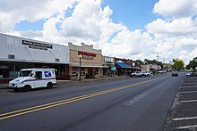
State Highway 8 is a north–south state highway in the U.S. state of Texas that runs from the Red River, which serves as the boundary between Texas and Arkansas, north of New Boston to SH 155 at Linden.

<span class="mw-page-title-main">Texas State Highway 11</span> State highway in Texas

State Highway 11 is a highway that runs from US 59 in Linden to SH 56 in Sherman in northeast Texas.

<span class="mw-page-title-main">Texas State Highway 46</span> State highway in Texas

State Highway 46 is a 71.4-mile (114.9 km) state highway in the U.S. state of Texas that runs from SH 16 east of Bandera to the intersection of SH 123 and SH 123 Business just south of Seguin.

<span class="mw-page-title-main">Texas State Highway 19</span> State highway in Texas

State Highway 19 is a state highway in Texas runs from Huntsville to Paris in east Texas.

<span class="mw-page-title-main">Texas State Highway 21</span> State highway in Texas

State Highway 21 runs from the Texas-Louisiana boundary east of San Augustine to San Marcos in east and central Texas. SH 21 mostly follows the alignment of the Old San Antonio Road and the El Camino Real, except for the portion between Midway and Bryan, where the Old San Antonio Road took a more northerly route, and SH 21 follows a more direct route. That section of the Old San Antonio Road is served by Texas State Highway OSR.

<span class="mw-page-title-main">Texas State Highway 24</span> State highway in Texas

State Highway 24 runs from Campbell to Paris in north Texas. It is a portion of the main route, along with Interstate 30, from Paris to the Dallas–Fort Worth metroplex.

<span class="mw-page-title-main">Texas State Highway 114</span> State highway in Texas, United States

State Highway 114 is a state highway that runs from the Dallas-Fort Worth Metroplex westward across Texas to the New Mexico state line, where it becomes New Mexico State Road 114, which eventually ends at Elida, New Mexico at US 70 / NM 330.

<span class="mw-page-title-main">Texas State Highway 64</span> State highway in Texas

State Highway 64 is a Texas state highway that runs from Wills Point via Tyler to Henderson.

<span class="mw-page-title-main">Texas State Highway 37</span> State highway in Wood, Franklin, and Red River counties in Texas, United States

State Highway 37 is a state highway that runs from the Oklahoma state line near Albion to Mineola in the northeast corner of the state.

<span class="mw-page-title-main">Texas State Highway 43</span> State highway in Texas

State Highway 43 is a Texas state highway that runs from Henderson to Atlanta.

<span class="mw-page-title-main">Texas State Highway 44</span> State highway in Texas

State Highway 44 (SH 44) is a Texas state highway that runs from west of Encinal to Corpus Christi, Texas. This highway is also known as the Cesar Chavez Memorial Highway outside the city limits of Robstown, Banquete, Agua Dulce, Alice, and Corpus Christi in Nueces and Jim Hogg counties.

<span class="mw-page-title-main">Texas State Highway 50</span> State highway in Texas

State Highway 50 (SH 50) is a 11.679-mile-long (18.796 km) state highway in the northeastern part of the U.S. state of Texas. Its southern terminus is at SH 24 and SH 224 near Commerce. Its northern terminus is at SH 34 in Ladonia. It previously extended northward from Ladonia to Honey Grove, concurrent with SH 34, and southward to Interstate 30 (I-30), concurrent with SH 24. The duplications of these highways were removed in 2003 and 2009, respectively.

<span class="mw-page-title-main">Texas State Highway 70</span> State highway in Texas

State Highway 70 is a state highway in Texas. The route runs approximately 315 miles (507 km) from US 277 near Blackwell to US 83 south of Perryton.

<span class="mw-page-title-main">Texas State Highway 72</span> State highway in Texas

State Highway 72 is a Texas state highway that runs approximately 111 miles (179 km) from near Fowlerton to Cuero in South Texas.

<span class="mw-page-title-main">Texas State Highway 158</span>

State Highway 158 is a state highway running from near Goldsmith, Texas eastward to Ballinger, Texas.

<span class="mw-page-title-main">Texas State Highway 110</span>

State Highway 110 is a state highway in the U.S. state of Texas that runs from Grand Saline to Rusk.

<span class="mw-page-title-main">Texas State Highway 149</span>

State Highway 149 is a state highway that runs from Carthage to Longview in east Texas.

<span class="mw-page-title-main">Texas State Highway 173</span>

State Highway 173 (SH 173) is a state highway that runs for 97.9 miles (157.6 km) from Jourdanton to Kerrville in south Texas, traversing through the Texas Hill Country.

<span class="mw-page-title-main">Texas State Highway 214</span>

State Highway 214 (SH 214) is a Texas state highway that runs from Adrian to Seminole.

References

  1. Transportation Planning and Programming Division (n.d.). "State Highway No. 154". Highway Designation Files. Texas Department of Transportation . Retrieved 2010-06-15.
  2. "Minutes" (PDF). publicdocs.txdot.gov. Texas Department of Transportation. February 8, 1933. Archived (PDF) from the original on February 3, 2018. Retrieved 4 May 2023.
  3. "Minutes" (PDF). publicdocs.txdot.gov. Texas Department of Transportation. July 15, 1935. Archived (PDF) from the original on October 20, 2017. Retrieved 4 May 2023.
  4. "Minutes" (PDF). publicdocs.txdot.gov. Texas Department of Transportation. December 21, 1936. Archived (PDF) from the original on October 19, 2017. Retrieved 4 May 2023.
  5. "Minutes" (PDF). publicdocs.txdot.gov. Texas Department of Transportation. July 31, 1937. Archived (PDF) from the original on October 21, 2017. Retrieved 4 May 2023.
  6. "Minutes" (PDF). publicdocs.txdot.gov. Texas Department of Transportation. November 15, 1937. Archived (PDF) from the original on February 19, 2018. Retrieved 4 May 2023.
  7. "Marshall-Gilmer Highway Number Changed to 154". The Marshall News Messenger. March 8, 1940. p. 8. Retrieved September 17, 2017 via Newspapers.com. Open Access logo PLoS transparent.svg
  8. Transportation Planning and Programming Division (n.d.). "Farm to Market Road No. 64". Highway Designation Files. Texas Department of Transportation . Retrieved November 6, 2017.
  9. Transportation Planning and Programming Division (n.d.). "State Highway Loop No. 390". Highway Designation Files. Texas Department of Transportation . Retrieved November 6, 2017.