Thompson, Ohio

Last updated

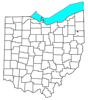
Thompson is an unincorporated community in Thompson Township, Geauga County, in the U.S. state of Ohio at an elevation of 1270 ft (287 m). [1] The Thompson Ledges, an important geologic and topographic feature of northeast Ohio, are located nearby. [2] [3]

Thompson Township, Geauga County, Ohio Township in Ohio, United States

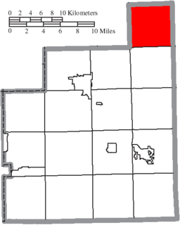
Thompson Township is one of the sixteen townships of Geauga County, Ohio, United States. As of the 2010 census the population was 2,269.

Geauga County, Ohio County in the United States

Geauga County is a county in the U.S. state of Ohio. As of the 2010 census, the population was 93,389. The county seat is Chardon. The county is named for a Onondaga or Seneca language word meaning 'raccoon', originally the name of the Grand River.

U.S. state constituent political entity of the United States

In the United States, a state is a constituent political entity, of which there are currently 50. Bound together in a political union, each state holds governmental jurisdiction over a separate and defined geographic territory and shares its sovereignty with the federal government. Due to this shared sovereignty, Americans are citizens both of the federal republic and of the state in which they reside. State citizenship and residency are flexible, and no government approval is required to move between states, except for persons restricted by certain types of court orders. Four states use the term commonwealth rather than state in their full official names.

Contents

History

A post office called Thompson has been in operation since 1825. [4] The community has the name of Matthew Thompson, a pioneer settler. [5]

Education

Public education in Thompson is administered by the Berkshire Local Schools district. [6] Thompson has a public library, a branch of the Geauga County Public Library. [7]

Geauga County Public Library, founded in 1848, is the main library system for Geauga County, Ohio.

Related Research Articles

Chesterland, Ohio Census-designated place in Ohio, United States

Chesterland is a census-designated place (CDP) in Geauga County, Ohio, United States. As of the 2010 census, the CDP had a population of 2,521.

Aurora, Ohio City in Ohio, United States

Aurora is a city in Portage County, Ohio, United States. It is co-extant with, and formed from, the former township of Aurora, which was formed from the Connecticut Western Reserve. The population was 15,548 at the 2010 census. It is part of the Akron metropolitan area.

Bainbridge, Geauga County, Ohio Census-designated place in Ohio, United States

Bainbridge is a census-designated place (CDP) in Bainbridge Township, Geauga County, Ohio, United States. As of the 2010 census, the CDP had a population of 3,267.

Tinker's Creek, in Cuyahoga, Summit and Portage counties, is the largest tributary of the Cuyahoga River, providing about a third of its flow into Lake Erie.

North Jackson, Ohio human settlement in United States of America

North Jackson is an unincorporated community in central Jackson Township, Mahoning County, Ohio, United States. Although it is unincorporated, it has a post office, with the ZIP code of 44451. It lies along State Route 45 between Salem and Warren. The community is part of the Youngstown-Warren-Boardman, OH-PA Metropolitan Statistical Area.

Little Mountain is a hill in the northeastern region of the U.S. state of Ohio, located on the border between Chardon Township in Geauga County and Concord Township in Lake County, with an elevation of 1,220 feet (370 m). Along with nearby Gildersleeve Mountain, Brown Mountain, and Thompson Ledges, it is located along the northern ridge of an extension of the Allegheny Plateau.

Cobbs Corners is a former settlement in Portage County, in the U.S. state of Ohio. It was located in Mantua Township.

Bostwick is an unincorporated community in Geauga County, in the U.S. state of Ohio.

Bundysburg is an unincorporated community in Geauga County, in the U.S. state of Ohio.

Fowlers Mill is an unincorporated community in Geauga County, in the U.S. state of Ohio.

Fullertown is an unincorporated community in Geauga County, in the U.S. state of Ohio.

Hampden is an unincorporated community in Geauga County, in the U.S. state of Ohio.

Huntsburg is an unincorporated community in Huntsburg Township, Geauga County, in the U.S. state of Ohio.

Newbury Center is an unincorporated community in Geauga County, in the U.S. state of Ohio.

Russell Center is an unincorporated community in Geauga County, in the U.S. state of Ohio.

South Newbury is an unincorporated community in Geauga County, in the U.S. state of Ohio.

South Thompson is an unincorporated community in Geauga County, in the U.S. state of Ohio.

Popes Corners is an unincorporated community in Geauga County, in the U.S. state of Ohio.

References

  1. U.S. Geological Survey Geographic Names Information System: Thompson
  2. "Marker #6-28 Thompson Ledges / Thompson Ledges Park". Remarkable Ohio: Marking Ohio's History. Ohio Historical Society. Retrieved 9 June 2016.
  3. "USGS Place Name: Thompson". MyTopo. Retrieved 9 June 2016.
  4. "Geauga County". Jim Forte Postal History. Retrieved 26 January 2016.
  5. "Miscellaneous bits of Thompson History". Thompson Township, OH. Retrieved 26 January 2016.
  6. "School districts". County of Geauga, Ohio. Retrieved 25 February 2018.
  7. "Locations". Geauga County Public Library. Retrieved 25 February 2018.

Coordinates: 41°41′24″N81°03′05″W / 41.69000°N 81.05139°W / 41.69000; -81.05139

Geographic coordinate system Coordinate system

A geographic coordinate system is a coordinate system that enables every location on Earth to be specified by a set of numbers, letters or symbols. The coordinates are often chosen such that one of the numbers represents a vertical position and two or three of the numbers represent a horizontal position; alternatively, a geographic position may be expressed in a combined three-dimensional Cartesian vector. A common choice of coordinates is latitude, longitude and elevation. To specify a location on a plane requires a map projection.