
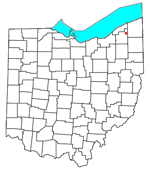
Geauga County is a county in the U.S. state of Ohio. As of the 2020 census, the population was 95,397. The county seat and largest city is Chardon.

U.S. Route 322 is a 494-mile-long (795.0 km), east–west United States Highway, traversing Ohio, Pennsylvania, and New Jersey. The road is a spur of US 22 and one of the original highways from 1926. A portion of it at one time was concurrent with the Lakes-to-Sea Highway.

Montville Township is one of the sixteen townships of Geauga County, Ohio, United States. As of the 2020 census the population was 1,938.

Munson Township is one of the sixteen townships of Geauga County, Ohio, United States. As of the 2020 census the population was 7,087.

Lees Creek, also known as Centerville, is an unincorporated community in central Wayne Township, Clinton County, Ohio, United States. It lies at the intersection of State Route 729 with Cox Road, 6 miles south of Sabina and 12 miles (19 km) southeast of Wilmington, the county seat of Clinton County. It lies between the headwaters of the Middle Fork of Lees Creek, to the southeast, and the Anderson Fork of Caesar Creek. it had a post office, with the ZIP code 45138. The Post Office closed in 2012 and the town, including East Clinton High School, now carries a Sabina mailing address.

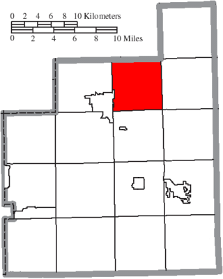
Claridon Township is one of the sixteen townships of Geauga County, Ohio, United States. As of the 2020 census the population was 3,103, of whom 2,865 lived in the unincorporated portions of the township.
Hambden Township is one of the sixteen townships of Geauga County, Ohio, United States. As of the 2020 census the population was 4,676, up from 4,024 at the 2000 census.

Williamstown is an unincorporated community in southern Madison Township, Hancock County, Ohio, United States. Although it is unincorporated, it has its own zip code of 45897. It lies at the intersection of U.S. Routes 30 and 68.
Montville is an unincorporated community in central Montville Township, Geauga County, Ohio, United States. It has a post office with the ZIP code 44064. It lies at the intersection of U.S. Route 6 with State Route 528.

Cuba is an unincorporated community in western Washington Township, Clinton County, Ohio, United States. It has a post office with the ZIP code 45114. It lies at the intersection of U.S. Route 68 with State Route 350. In addition to the post office, the community is home to the Cuba Friends Meeting, a part of the Wilmington Yearly Meeting of the Society of Friends.

Marathon is an unincorporated community and Census-designated place in northeastern Jackson Township, Clermont County, Ohio, United States. Although it is unincorporated, it had a post office, with the ZIP code 45145. The current ZIP code is 45118. It lies along U.S. Route 50.

Rosewood is an unincorporated community and census-designated place (CDP) in northwestern Adams Township, Champaign County, Ohio, United States. As of the 2020 census it had a population of 224. It has a post office with the ZIP code 43070. It lies along State Route 29, an east–west highway.

Mount Liberty is an unincorporated community on the border between the Milford and Liberty Townships of Knox County, Ohio, United States. It has a post office with the ZIP code 43048. It lies along the concurrent U.S. Route 36 and State Route 3.

Ellsworth is an unincorporated community in central Ellsworth Township, Ohio, United States. It is part of the Youngstown–Warren metropolitan area. It lies at the intersection of U.S. Route 224 and State Route 45, and has a post office with the ZIP code 44416.
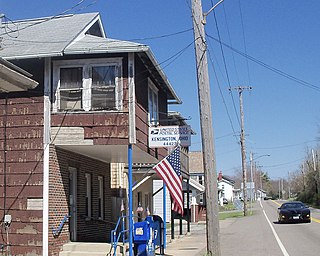
Kensington is an unincorporated community in southwestern Hanover Township, Columbiana County, Ohio, United States. Lying along U.S. Route 30 at its intersection with Ohio State Routes 9 and 644, it has a post office with the ZIP code 44427. Kensington is a part of the Salem micropolitan area, 23 miles (37 km) miles east of Canton and 30 miles (48 km) southwest of Youngstown.

East Rochester is an unincorporated community and census-designated place (CDP) in southern West Township, Columbiana County, Ohio, United States. The population was 224 as of the 2020 census. It lies along U.S. Route 30, and has a post office with the ZIP code 44625. It is a part of the Salem micropolitan area, about 20 miles (32 km) east of Canton.

Williamsfield is an unincorporated community in central Williamsfield Township, Ashtabula County, Ohio, United States. It has a post office with the ZIP code 44093. It lies at the intersection of U.S. Route 322 with State Route 7. In 2014, it was named the most stressed community in the United States.
Robertsville is an unincorporated community and census-designated place in western Paris Township, Stark County, Ohio, United States. It has a post office with the ZIP code 44670. It lies along U.S. Route 30 between East Canton and Minerva and is in the Minerva Local School District. The community is part of the Canton–Massillon Metropolitan Statistical Area. The population was 293 at the 2020 census.
Claridon is an unincorporated community in Claridon Township, Geauga County, Ohio, United States. It is located on U.S. Route 322 southeast of Chardon and to the west of East Claridon.

Claridon is an unincorporated community in Marion County, Ohio, United States. Claridon is located on Ohio State Route 95, 7 miles (11 km) east of Marion, between Marion and Mt. Gilead. The community is served by River Valley Local School District.

