Timnath, Colorado | |
---|---|
Coordinates: 40°31′45″N104°59′07″W / 40.52917°N 104.98528°W | |
Country | United States |
State | Colorado |
County [1] | Larimer |
Settled | 1869 |
Established | 1882 |
Incorporated | July 6, 1920 [2] |
Named for | Biblical city of Timnath |
Government | |
• Type | Home Rule Town [1] |
• Mayor | Mark Soukup |
Area | |
• Total | 7.345 sq mi (19.023 km2) |
• Land | 7.308 sq mi (18.928 km2) |
• Water | 0.037 sq mi (0.095 km2) |
Elevation | 4,869 ft (1,484 m) |
Population | |
• Total | 6,487 |
• Estimate (2023) [6] | 9,991 |
• Density | 1,279.0/sq mi (493.7/km2) |
Time zone | UTC–7 (Mountain (MST)) |
• Summer (DST) | UTC–6 (MDT) |
ZIP Codes [7] | 80547 |
Area code | 970 |
FIPS code | 08-77510 |
GNIS feature ID | 0180510 [4] |
Sales tax | 6.7% [8] |
Website | timnath.org |
The Town of Timnath is a Statutory Town located in Larimer County, Colorado, United States. Founded in 1882, Timnath is a small agricultural/farming community located southeast of Fort Collins, Colorado, approximately one-half mile east of the Harmony Road/Interstate 25 interchange, on a small bluff east of the Cache la Poudre River. The surrounding farmlands have been used primarily for potatoes, alfalfa, sugar beets, and cattle. Although the town has remained virtually unchanged in recent decades, the encroaching growth of both Fort Collins to the west and Windsor to the south have placed the town in an area considered favorable to development. The population was 6,487 at the 2020 census. [5] Timnath has been one of the fastest-growing communities in Colorado since 2020, and in 2022 had an estimated population of 9,344.
Other structures lining Main Street (a section of County Road 5) include elementary school (in the Poudre School District), a one-story modern post-office, and several other historic buildings. Most residences are single-family homes. There is another elementary school (Bethke Elementary) 2.8 miles away from the one lining Main Street.
The area was first homesteaded by settlers in 1869. The first schoolhouse was constructed that year, approximately one-half mile west of the current town, and was named "Fairview". By 1880, the community had outgrown the schoolhouse, and new "Fairview" school was built just north of the current town. The school also served as an early meeting place for the Presbyterian Church. The turning point in the early history of the community was in 1882, with the arrival of the Greeley, Salt Lake and Pacific Railroad (controlled by the Union Pacific) linking Greeley and Fort Collins. The following year, the Presbyterian Church, petitioned by local residents, sent a missionary to found a congregation. The current structure along Main Street dates from that year.
A post office was established in 1884, headed by Reverend Charles A. Taylor, the local Presbyterian minister. When the post office was formed, Taylor bestowed the current name of the town from the 14th chapter of the Book of Judges, as the place where Samson went to obtain a Philistine wife. In 1900 the second school became outdated and a new one was built, dropping the name "Fairview" permanently. This structure currently stands as an out-building to the current elementary school. A larger school was built in 1918 (which burned in 1935 and was rebuilt the following year). The school district was consolidated with that of Fort Collins in 1960.
During World War II, the Empire of Japan launched Fu-Go balloon bombs that floated across the Pacific to the U.S. One of these bombs dropped and exploded in a field in Timnath. [9]
Timnath is located at 40° 31' 44.94" N, 104° 59' 6.91" W (40.5291491, -104.9852533).
According to the United States Census Bureau, the town has a total area of 7.345 square miles (19.02 km2), of which 7.308 square miles (18.93 km2) is land and 0.037 square miles (0.10 km2) is water. [3]
The historical downtown lies along County Road Five, which runs north–south parallel to Interstate 25 half a mile to the east. Since the 2000 census, the town of Timnath has annexed several square miles of land to the east and southeast; the town has experienced significant commercial development along the east–west corridor of County Road 38 (Harmony Road). The majority of the six mile (north-south) by three mile (east-west) block of land that lies within Timnath's growth management area is low-density residential or agricultural, and is designated to remain so, with open space and parkland filling the remainder of the area, particularly near the Poudre River and Timnath Reservoir.
Timnath is a Home Rule Town, governed by a Town Council, which consists of five elected officials - one Mayor and four Council Members, all positions are elected "at large," meaning that candidates come from all areas of the town. Elected officials serve 4 year terms.
Council meetings are open, public meetings where the Council makes town decisions and creates local laws and policies. The Council holds regular meetings on the second and fourth Tuesday of each month at 6 p.m. Unless otherwise noted, all meetings are held at the Town Administration Building at 4800 Goodman Street.
The Town Council appoints the Town Manager who is responsible for the administration and daily operations of the Town.
Police services are provided by the Timnath Police Department and the Larimer County Sheriff's Department. Fire protection is provided by Poudre Fire Authority.
Census | Pop. | Note | %± |
---|---|---|---|
1930 | 169 | — | |
1940 | 147 | −13.0% | |
1950 | 177 | 20.4% | |
1960 | 150 | −15.3% | |
1970 | 177 | 18.0% | |
1980 | 185 | 4.5% | |
1990 | 190 | 2.7% | |
2000 | 223 | 17.4% | |
2010 | 625 | 180.3% | |
2020 | 6,487 | 937.9% | |
2023 (est.) | 9,991 | [6] | 54.0% |
U.S. Decennial Census [10] 2020 Census [5] |
Race | Number | Percent |
---|---|---|
White (NH) | 5,271 | 81.3% |
Black or African American (NH) | 39 | 0.6% |
Native American or Alaska Native (NH) | 12 | 0.2% |
Asian (NH) | 299 | 4.6% |
Pacific Islander (NH) | 1 | 0.0% |
Some Other Race (NH) | 38 | 0.6% |
Mixed/Multi-Racial (NH) | 288 | 4.4% |
Hispanic or Latino | 539 | 8.3% |
Total | 6,487 | 100.00% |
As of the 2020 census, there were 6,487 people, 2,002 households, and 1,814 families residing in the town. [12] The population density was 988.1 inhabitants per square mile (381.5/km2). There were 2,213 housing units. The racial makeup of the town was 83.8% White, 0.6% African American, 0.3% Native American, 4.7% Asian, 0.0% Pacific Islander, 1.6% from some other races and 9.0% from two or more races. Hispanic or Latino of any race were 8.3% of the population. [13] 33.2% of residents were under the age of 18, 6.8% were under 5 years of age, and 14.5% were 65 and older.
As of the 2010 census, there were 625 people, 214 households, and 179 families residing in the town. The population density was 129.4 inhabitants per square mile (50.0/km2). There were 243 housing units. The racial makeup of the town was 94.4% White, 0.6% African American, 0.0% Native American, 1.1% Asian, 0.3% Pacific Islander, 1.4% from other races, and 2.1% from two or more races. 6.1% of the population were Hispanic or Latino of any race.
There were 214 households, out of which 46.7% had children under the age of 18 living with them, 72.0% were married couples living together, 7.9% had a female householder with no husband present, 3.7% had a male householder with no wife present, and 16.4% were non-families. 14.0% of all households were made up of individuals, and 1.4% had someone living alone who was 65 years of age or older. The average household size was 2.92 and the average family size was 3.23.
In the town, the population was spread out, with 32.3% under the age of 18, 5.5% from 18 to 24, 27.7% from 25 to 44, 27.1% from 45 to 64, and 7.4% who were 65 years of age or older. The median age was 35.4 years. For every 100 females, there were 98.4 males.
In the 2009-2013 American Community Survey, the median income for a household in the town was $113,144, and the median income for a family was $114,318. The per capita income for the town was $40,889. 1.5% of the population and 1.1% of families were below the poverty line. 1.0% of those under the age of 18 and 0.0% of those 65 and older were living below the poverty line.
Timnath has experienced significant population growth in recent years and was the fastest growing town in Colorado in 2022 (19.2%) and the fastest growing town in Colorado since the start of the decade (44.0%).
Tallapoosa County is located in the east-central portion of the U.S. state of Alabama. As of the 2020 census, the population was 41,311. Its county seat is Dadeville. Its largest city is Alexander City.
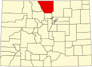
Larimer County is a county located in the U.S. state of Colorado. As of the 2020 census, the population was 359,066. The county seat and most populous city is Fort Collins. The county was named for William Larimer, Jr., the founder of Denver.
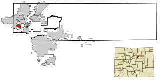
Sherrelwood is an unincorporated community and a census-designated place (CDP) located in and governed by Adams County, Colorado, United States. The CDP is a part of the Denver–Aurora–Lakewood, CO Metropolitan Statistical Area. The population was 19,228 at the 2020 census.
Fairview Shores is a census-designated place and an unincorporated area in Orange County, Florida, United States. The population was 10,239 at the 2010 census. It is part of the Orlando–Kissimmee–Sanford, Florida Metropolitan Statistical Area.
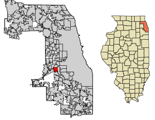
Justice is a village in Cook County, Illinois, United States, established in 1911. Per the 2020 census, the population was 12,600.
Fairview Heights is a city in St. Clair County, Illinois, United States within Greater St. Louis. It is an eastern suburb of St. Louis. The population was 17,078 at the 2010 census. Fairview Heights is a dominant shopping center for Greater St. Louis and Southern Illinois and includes numerous shopping plazas and St. Clair Square mall.
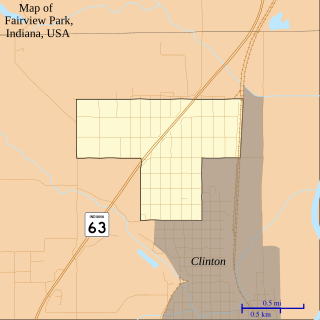
Fairview Park is a town in Clinton Township, Vermillion County, in the U.S. state of Indiana. The population was 1,386 at the 2010 census.
Garnett is a city in and the county seat of Anderson County, Kansas, United States. As of the 2020 census, the population of the city was 3,242.
Kiowa is a city in Barber County, Kansas, United States. As of the 2020 census, the population of the city was 902. It is located 1 mile north of the Kansas / Oklahoma state border.
Fairview is a city in Brown County, Kansas, United States. As of the 2020 census, the population of the city was 240.
Howard is a city in and the county seat of Elk County, Kansas, United States. As of the 2020 census, the population of the city was 570.
Nortonville is a city in Jefferson County, Kansas, United States. As of the 2020 census, the population of the city was 601.
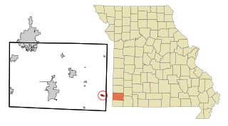
Fairview is a city in southeastern Newton County, Missouri, United States. The population was 383 at the 2010 census. It is part of the Joplin, Missouri Metropolitan Statistical Area.
Fairview is a town in Richland County, Montana, United States. The population was 896 at the 2020 census. The town is directly on the North Dakota border. Fairview incorporated in 1913.
Fairview is an unincorporated community and census-designated place (CDP) located within Middletown Township, in Monmouth County, in the U.S. state of New Jersey. As of the 2010 United States Census, the CDP's population was 3,806.
Fairview is a hamlet and a census-designated place (CDP) located in the town of Greenburgh, Westchester County, New York, United States. The population was 3,099 at the 2010 census. As of 2000, Fairview had the fourth-highest percentage of African-Americans in New York.
Fairview is a city in Major County, Oklahoma, United States. The population was 2,740 at the time of the 2020 Census. It is the county seat of Major County.
Fairview Township is a township in Butler County, Pennsylvania, United States. The population was 1,942 at the 2020 census.
Fairview is a town in Marion County, West Virginia, United States. The population was 374 at the 2020 census.
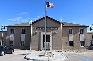
Box Elder is a city in Pennington and Meade counties in the State of South Dakota. The population was 11,746 at the 2020 census, making it the 10th most populous city in South Dakota. Ellsworth Air Force Base lies on the northeast side of the city.