Wellington, Colorado

Last updated

Town of Wellington, Colorado
Wellington, Colorado.JPG
Looking west on Cleveland Avenue in Wellington.
Nickname: 
Colorado's Northern Gateway
Larimer County Colorado Incorporated and Unincorporated areas Wellington Highlighted 0883230.svg
Location of Wellington in Larimer County, Colorado.
Coordinates: 40°42′8″N105°0′2″W / 40.70222°N 105.00056°W / 40.70222; -105.00056
Country Flag of the United States.svg  United States
State Flag of Colorado.svg  Colorado
County [1] Larimer County
Founded1902
Incorporated November 10, 1905 [2]
Named for C. L. Wellington
Government
  Type Statutory Town [1]
   Mayor Calar Chaussee
Area
[3]
  Total3.63 sq mi (9.41 km2)
  Land3.63 sq mi (9.40 km2)
  Water0.00 sq mi (0.01 km2)  0.0%
Elevation
5,200 ft (1,585 m)
Population
 (2020)
  Total11,047
  Estimate 
(2021) [3]
11,722
  Density3,000/sq mi (1,200/km2)
  [3]
Time zone UTC-7 (MST)
  Summer (DST) UTC-6 (MDT)
ZIP code [4]
80549
Area code 970
FIPS code 08-83230
GNIS feature ID 0202441
Website Town of Wellington

Wellington is a statutory town in Larimer County, Colorado, United States. The population was 11,047 at the 2020 census. [3] Wellington is situated in the northern part of Colorado, and it is part of the Fort Collins-Loveland Metropolitan Statistical Area.[ citation needed ]

Contents

Geography

Wellington is located at 40°42′8″N105°0′20″W / 40.70222°N 105.00556°W / 40.70222; -105.00556 (40.702324, -105.005497). [5]

According to the United States Census Bureau, the town has a total area of 1.8 square miles (4.7 km2), all of it land.

Wellington is I-25's northernmost Colorado town.

Demographics

Historical population
CensusPop.Note
1910 459
1920 439−4.4%
1930 53321.4%
1940 465−12.8%
1950 54116.3%
1960 532−1.7%
1970 69129.9%
1980 1,21575.8%
1990 1,34010.3%
2000 2,67299.4%
2010 6,289135.4%
2020 11,04775.7%
2021 (est.)11,722 [3] 6.1%
U.S. Decennial Census [6] [ failed verification ] 2020 [3]

As of the census [7] of 2000, there were 2,672 people, 932 households, and 693 families residing in the town. The population density was 1,509.7 inhabitants per square mile (582.9/km2). There were 963 housing units at an average density of 544.1 per square mile (210.1/km2). The racial makeup of the town was 87.39% White, 0.26% African American, 1.05% Native American, 0.67% Asian, 0.07% Pacific Islander, 8.23% from other races, and 2.32% from two or more races. Hispanic or Latino of any race were 12.13% of the population.

There were 932 households, out of which 46.4% had children under the age of 18 living with them, 61.1% were married couples living together, 8.8% had a female householder with no husband present, and 25.6% were non-families. 17.5% of all households were made up of individuals, and 4.2% had someone living alone who was 65 years of age or older. The average household size was 2.86 and the average family size was 3.27.

In the town, the population was spread out, with 32.7% under the age of 18, 7.6% from 18 to 24, 38.2% from 25 to 44, 16.5% from 45 to 64, and 5.1% who were 65 years of age or older. The median age was 30 years. For every 100 females, there were 99.7 males. For every 100 females age 18 and over, there were 101.0 males.

The median income for a household in the town was $47,917, and the median income for a family was $48,214. Males had a median income of $34,107 versus $25,991 for females. The per capita income for the town was $17,783. About 5.1% of families and 7.3% of the population were below the poverty line, including 8.4% of those under age 18 and 13.4% of those age 65 or over.

As of 2013, 6,725 people live in Wellington. [8]

Law and government

Wellington is a statutory town regulated by the state statutes listed in the Colorado Revised Statutes. The board of trustees may approve ordinances that pertain to local issues.

The legislative authority of the town shall be vested in a board of trustees, consisting of 1 mayor and 6 trustees. The members of the board of trustees are elected for 4-year terms and are elected at large. The mayor is elected separately.

PositionName
MayorCalar Chaussee
TrusteeShirrell M. Tietz
TrusteeJon Gaiter
TrusteeDave Wiegand
TrusteeAshley MacDonald (Mayor Pro Tem)
TrusteeBrian Mason
State RepresentativeMike Lynch
State SenatorJanice Marchman
Federal RepresentativeKen Buck
Federal SenatorMichael Bennet
Federal SenatorJohn Hickenlooper

History

Founded in 1902, incorporated in 1905, and named for C. L. Wellington (an employee of the Colorado and Southern Railroad). U.S. Supreme Court Justice Byron White lived in Wellington as a child. He made a point of returning to Wellington on an annual basis for his high school reunions up until 1999 when his physical health worsened significantly.

In the early 20th century, especially during the years of prohibition, Wellington doubled as a place to drink and a service town for drivers commuting from Cheyenne to Fort Collins and vice versa. The town, more or less, sustained a population of 500 throughout the century which proceeded to build homes, restaurants, churches, and various other elements of small-town life.

In 2000, woolly mammoth remains were discovered by a construction crew while digging home foundations. Colorado State University sent a team to carefully excavate and preserve the bones of the extinct animals; Wellington residents watched attentively. Unfortunately, upon hoisting the remains out of the excavation site the tusks crumbled inside of the protective forms that were previously built around them. Rear molars and parts of the skull of the mammoth are housed at CSU after being donated by the Burrus family (the developers of the project), who also kept molars of the animal. The subdivision where the bones were found named one of its streets in remembrance of the excitement.

Though population remained steady throughout the 20th century, Wellington experienced moderate growth in the 1990s and 2000s, rendering it a sort of bedroom community for the city of Fort Collins, which lies 10 miles to the south.

Education

Wellington is home to three schools: Rice Elementary, Eyestone Elementary and Wellington Middle-High School, all part of Poudre School District. The former Wellington Middle School was honored with many national and state awards [9] including:

See also

Related Research Articles

<span class="mw-page-title-main">Fort Collins, Colorado</span> City in Colorado, United States

Fort Collins is a home rule municipality that is the county seat and the most populous municipality of Larimer County, Colorado, United States. The city population was 169,810 at the 2020 census, an increase of 17.94% since 2010. Fort Collins is the principal city of the Fort Collins, CO Metropolitan Statistical Area and is a major city of the Front Range Urban Corridor. The city is the fourth most populous city in Colorado. Situated on the Cache La Poudre River along the Colorado Front Range, Fort Collins is located 56 mi (90 km) north of the Colorado State Capitol in Denver. Fort Collins is a midsize college town, home to Colorado State University and Front Range Community College's Larimer campus.

<span class="mw-page-title-main">Morgan County, Colorado</span> County in Colorado, United States

Morgan County is a county located in the U.S. state of Colorado. As of the 2020 census, the population was 29,111. The county seat is Fort Morgan. The county was named after old Fort Morgan, which in turn was named in honor of Colonel Christopher A. Morgan.

<span class="mw-page-title-main">Larimer County, Colorado</span> County in Colorado, United States

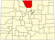
Larimer County is a county located in the U.S. state of Colorado. As of the 2020 census, the population was 359,066. The county seat and most populous city is Fort Collins. The county was named for William Larimer, Jr., the founder of Denver.

<span class="mw-page-title-main">Jackson County, Colorado</span> County in Colorado, United States

Jackson County is a county located in the U.S. state of Colorado. As of the 2020 census, the population was 1,379, and it was the fourth least populated in the state. The county is named after the United States President Andrew Jackson. The county seat and only municipality in the county is Walden.

<span class="mw-page-title-main">Grand County, Colorado</span> County in Colorado, United States

Grand County is a county located in the U.S. state of Colorado. As of the 2020 census, the population was 15,717. The county seat is Hot Sulphur Springs.

<span class="mw-page-title-main">Clear Creek County, Colorado</span> County in Colorado, United States

Clear Creek County is a county located in the U.S. state of Colorado. As of the 2020 census, the population was 9,397. The county seat is Georgetown.

<span class="mw-page-title-main">Springfield, Colorado</span> Town in Colorado, United States

Springfield is a Statutory Town which is also the county seat and most populous town in Baca County, Colorado, United States. The population was 1,325 at the 2020 census.

<span class="mw-page-title-main">Berthoud, Colorado</span> Town in Colorado, United States

Berthoud is a statutory town located in Larimer and Weld counties, Colorado, United States. The town population was 10,332 at the 2020 United States Census with 10,071 residing in Larimer County and 261 residing in Weld County. Berthoud is situated north of the Little Thompson River, 21 miles (34 km) south of Fort Collins and 43 miles (69 km) north of Denver in the Front Range Urban Corridor.

<span class="mw-page-title-main">Loveland, Colorado</span> City in Colorado, United States

Loveland is the home rule municipality that is the second most populous municipality in Larimer County, Colorado, United States. Loveland is situated 46 miles (74 km) north of the Colorado State Capitol in Denver and is the 14th most populous city in Colorado. As of the 2020 census the population of Loveland was 76,378. The city forms part of the Fort Collins-Loveland Metropolitan Statistical Area and the Front Range Urban Corridor. The city's public schools are part of the Thompson R2-J School District.

<span class="mw-page-title-main">Timnath, Colorado</span> Town in Colorado, United States

The Town of Timnath is a Statutory Town located in Larimer County, Colorado, United States. Founded in 1882, Timnath is a small agricultural/farming community located southeast of Fort Collins, Colorado, approximately one-half mile east of the Harmony Road/Interstate 25 interchange, on a small bluff east of the Cache la Poudre River. The surrounding farmlands have been used primarily for potatoes, alfalfa, sugar beets, and cattle. Although the town has remained virtually unchanged in recent decades, the encroaching growth of both Fort Collins to the west and Windsor to the south have placed the town in an area considered favorable to development. The population was 6,487 at the 2020 census. Timnath has been one of the fastest-growing communities in Colorado since 2020, and in 2021 had an estimated population of 7,839.

<span class="mw-page-title-main">Branson, Colorado</span> Town in Colorado, United States

Branson is a Statutory Town located in Las Animas County, Colorado, United States. The town population was 57 at the 2020 United States Census. Branson is the southernmost town in the State of Colorado, located just 0.3 miles (0.48 km) from the New Mexico border.

<span class="mw-page-title-main">Brush, Colorado</span> City in Colorado, United States

Brush is a Statutory City located in Morgan County, Colorado, United States. The city population was 5,339 at the 2020 United States Census. Brush is a part of the Fort Morgan, CO Micropolitan Statistical Area.

<span class="mw-page-title-main">Ault, Colorado</span> Town in Colorado, United States

Ault is a statutory town located in Weld County, Colorado, United States. The town population was 1,887 at the 2020 United States Census, a +24.23% increase since the 2010 United States Census. Ault is a part of the Greeley, CO Metropolitan Statistical Area and the Front Range Urban Corridor.

<span class="mw-page-title-main">Johnstown, Colorado</span> Town in Weld and Larimer counties in Colorado, United States

Johnstown is a home rule municipality in Weld and Larimer counties in the U.S. state of Colorado. The population was 17,303 at the 2020 United States Census.

<span class="mw-page-title-main">Marceline, Missouri</span> City in Missouri, United States

Marceline is a city in Chariton and Linn counties in the U.S. state of Missouri. The population was 2,123 at the 2020 census.

<span class="mw-page-title-main">Brownville (village), New York</span> Village in New York, United States

Brownville is a village in Jefferson County, New York, United States. The population was 1,119 at the 2010 census, up from 1,022 in 2000. The village is named after Jacob Brown, an early settler and developer.

<span class="mw-page-title-main">Colorado's 2nd congressional district</span> U.S. House district for Colorado

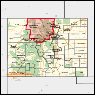
Colorado's 2nd congressional district is a congressional district in the U.S. state of Colorado. The district is located in the north-central part of the state and encompasses the northwestern suburbs of Denver including Boulder and Fort Collins. The district also includes the mountain towns of Vail, Granby, Steamboat Springs, and Idaho Springs. Redistricting in 2011 moved Larimer County, including the cities of Fort Collins and Loveland, to the 2nd from the 4th district. Meanwhile, redistricting in 2021 moved Loveland back to the 4th district and Broomfield and western Jefferson County to the 7th district.

<span class="mw-page-title-main">Fort Collins – Loveland Metropolitan Statistical Area</span> Metropolitan Statistical Area in Colorado, United States

The Fort Collins – Loveland Metropolitan Statistical Area is a United States Office of Management and Budget (OMB) defined Metropolitan Statistical Area (MSA) located in the Fort Collins and Loveland area in the North Central region of the U.S. state of Colorado. The Fort Collins–Loveland MSA is defined as Larimer County, Colorado. The Census Bureau estimates that the population was 362,533 in 2021. The Fort Collins–Loveland MSA is the 150th most populous MSA in the United States.

<span class="mw-page-title-main">North Central Colorado Urban Area</span> Metropolitan area of Colorado

The North Central Colorado Urban Area comprises the four contiguous metropolitan statistical areas in the north central region of the State of Colorado: the Denver–Aurora Metropolitan Statistical Area, the Boulder Metropolitan Statistical Area, the Fort Collins-Loveland Metropolitan Statistical Area, and the Greeley Metropolitan Statistical Area. With the exception of southeastern Elbert County, southeastern Park County, and tiny portions of southern Douglas County, the entire North Central Colorado Urban Area is drained by the South Platte River and its tributaries. The North Central Colorado Urban Area is the central, and the most populous, of the three primary subregions of the Front Range Urban Corridor.

<span class="mw-page-title-main">Green Mountain Falls, Colorado</span> Town in Colorado, United States

The Town of Green Mountain Falls is a Statutory Town located in El Paso and Teller counties of the U.S. of State of Colorado. The town population was 646 at the 2020 United States Census with 622 residents in El Paso County and 24 residents in Teller County. Green Mountain Falls is a part of the Colorado Springs, CO Metropolitan Statistical Area and the Front Range Urban Corridor.

References

  1. 1 2 "Active Colorado Municipalities". State of Colorado, Department of Local Affairs. Retrieved September 1, 2007.
  2. "Colorado Municipal Incorporations". State of Colorado, Department of Personnel & Administration, Colorado State Archives. December 1, 2004. Retrieved September 2, 2007.
  3. 1 2 3 4 5 6 "United States Census Bureau QuickFacts Wellington town, Colorado Files". census.gov. United States Census Bureau. Retrieved November 13, 2022.
  4. "ZIP Code Lookup" (JavaScript/HTML). United States Postal Service . Retrieved January 8, 2008.
  5. "US Gazetteer files: 2010, 2000, and 1990". United States Census Bureau. February 12, 2011. Retrieved April 23, 2011.
  6. "Census of Population and Housing". Census.gov. Retrieved June 4, 2015.
  7. "U.S. Census website". United States Census Bureau . Retrieved January 31, 2008.
  8. "Wellington, Colorado (CO 80549) profile: Population, maps, real estate, averages, homes, statistics, relocation, travel, jobs, hospitals, schools, crime, moving, houses, news, sex offenders".
  9. "About Our School | Wellington Middle School". wel.psdschools.org. Archived from the original on August 23, 2013.