
Tsing Ma Bridge is a bridge in Hong Kong. It is the world's 16th-longest span suspension bridge, and was the second longest at the time of its completion. The bridge was named after the two islands it connects, namely Tsing Yi and Ma Wan. It has two decks and carries both road and rail traffic, which also makes it the largest suspension bridge of this type. The bridge has a main span of 1,377 metres (4,518 ft) and a height of 206 metres (676 ft). The span is the longest of all bridges in the world carrying rail traffic.

Kwai Tsing is one of the 18 districts of Hong Kong. It consists of two parts - Kwai Chung and Tsing Yi Island. Kwai Tsing is part of the New Territories. It had a population of 520,572 in 2016. The district has the third least educated residents and their income is below average.

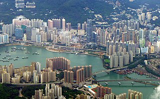
Tsing Yi, sometimes referred to as Tsing Yi Island, is an island in the urban area of Hong Kong, to the northwest of Hong Kong Island and south of Tsuen Wan. With an area of 10.69 km2 (4.13 sq mi), the island has been extended drastically by reclamation along almost all its natural shore and the annexation of Nga Ying Chau (牙鷹洲) and Chau Tsai. Three major bays or harbours, Tsing Yi Lagoon, Mun Tsai Tong and Tsing Yi Bay (青衣灣) in the northeast, have been completely reclaimed for new towns.
Tsuen Wan District is one of the 18 districts of Hong Kong. It is located in the New Territories and is served by the Tsuen Wan line of the MTR metro system. Its area is 60.7 km2. Its residents, who mostly live in Tsuen Wan Town, enjoy the highest income in the New Territories.
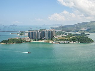
Ma Wan is an island of Hong Kong, located between Lantau Island and Tsing Yi Island, with an area of 0.97 square kilometres. Administratively, it is part of Tsuen Wan District.

Route 8 of Hong Kong is a dual 3-lane carriageway motorway that links Lantau Island, Tsing Yi Island, Cheung Sha Wan in West Kowloon, and Sha Tin in the southeast New Territories of Hong Kong. It is a combination of many sections.

Tuen Mun Road is a major expressway in Hong Kong which connects Tuen Mun with Tsuen Wan, within the New Territories. It is part of Hong Kong's Route 9, which circumnavigates the New Territories. Opened in 1978, it was once the major trunk route linking the northwest New Territories to urban Kowloon and is known for its frequent traffic jams and road accidents owing to its early design and heavy usage. As a result, speed limits have been enforced to 70–80 km/h (45–50 mph) due to geometric constraints.
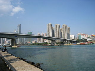
Tsing Yi North Bridge, also called Tsing Tsuen Bridge (青荃橋), connects the Tam Kon Shan Interchange on Tsing Yi Island to the Tsuen Tsing Interchange in Tsuen Wan, spanning the Rambler Channel. Inaugurated on 10 December 1987, the bridge was designed to improve access to Tsing Yi, which at that time was connected to Kwai Chung by only one fixed link, the heavily congested Tsing Yi Bridge.

Route 3 is a series of expressways in Hong Kong that runs from Sai Ying Pun on Hong Kong Island to Yuen Long in the New Territories, linking West Kowloon, Kwai Chung and Tsing Yi. It was built as part of the Airport Core Programme to provide access to Hong Kong International Airport from the city, and to relieve congestion in the New Territories. The Western Harbour Crossing and Tai Lam Tunnel that form part of the route are tollways.

Kwai Chung Road is a throughway in Kwai Chung of the New Territories in Hong Kong. It is one of the busiest roads in Hong Kong. The Transport Department has classified it as a trunk road.

Tsing Yi Peak, also known as Sam Chi Heung, is a hill with three peaks occupying the southern half of the Tsing Yi Island, Hong Kong. The hill is situated on the western half of Victoria Harbour. Its peaks are good locations to observe the harbour and the channels among harbour islands. While situated in the south, a short hill Liu To Shan occupies the northwest of the island.
Cheung Shue Tau is a place at the north shore of Tsing Yi Island, Hong Kong. The place is with many ship repairing factories that were relocated from Cheung Sha Wan. It is reachable by Tam Kon Shan Road. An expressway Tsing Yi North Coastal Road has been built on the hill above it and a viaduct connecting to Tam Kon Shan Road.

North Lantau Highway is an expressway forming part of Hong Kong's Route 8, linking Hong Kong International Airport and Lantau Island with the rest of the territory. The road has three lanes in each direction for its entire length with full-width hard shoulders for emergencies and breakdowns. The speed limit is 110 kilometres per hour (68 mph) for most of its length, the highest of any road in Hong Kong.

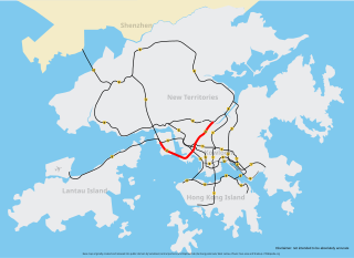
The Hong Kong Strategic Route and Exit Number System is a system adopted by the Transport Department of the Hong Kong Government to organise the major roads in the territory into routes 1 to 10 for the convenience of drivers. When the system was implemented in 2004, the government promoted it with a major public campaign, including the slogan "Remember the Numbers; Make Driving Easier".
Articles related to Hong Kong include:

The Hong Kong government started developing new towns in the 1950s to accommodate Hong Kong's booming population. During the first phase of development, the newly developed towns were called "satellite towns", a concept borrowed from the United Kingdom, of which Hong Kong was a colony. Kwun Tong, located in eastern Kowloon, and Tsuen Wan, located in the south-west of the New Territories, were designated as the first satellite towns, when the urban area in Hong Kong was still relatively small, restricted to the central and western parts of Kowloon Peninsula and the northern side of Hong Kong Island. Wah Fu Estate was also built in a remote corner on the southern side of Hong Kong Island, with similar concepts but at a smaller scale.
Tsing Sha Highway is a major expressway in Hong Kong, which links the island of Tsing Yi to Sha Tin. The road is part of Route 8, which starts in Sha Tin and terminates in Tung Chung. It was opened in March 2008 and extended in December 2009.
Tsing Lung Bridge (青龍大橋) is a proposed suspension bridge in Hong Kong, from North Lantau to Tsing Lung Tau, in the western New Territories, between Tsuen Wan and Tuen Mun, forming part of the Route 10 North Lantau to Yuen Long Highway. The bridge and highway have not been constructed. At the time of its announcement in 2002, it would have been the world's 4th-longest suspension bridge, with a main span of 1,418 metres (4,652 ft) - 41 metres longer than the Tsing Ma Bridge. Detailed planning was then complete and construction was due to commence in 2003 and be open to traffic in 2008.


