
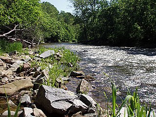
Tulpehocken Creek is a 39.5-mile-long (63.6 km) tributary of the Schuylkill River in southeastern Pennsylvania in the United States, and during the American Canal Age, once provided nearly half the length of the Union Canal linking the port of Philadelphia, the largest American city and the other communities of Delaware Valley with the Susquehanna basin and the Pennsylvania Canal System connecting the Eastern seaboard to Lake Erie and the new settlements of the Northwest Territory via the Allegheny}, Monongahela. and Ohio Rivers at Pittsburgh.

The Conestoga River, also referred to as Conestoga Creek, is a 61.6-mile-long (99.1 km) tributary of the Susquehanna River flowing through the center of Lancaster County, Pennsylvania, United States.
Pequea Creek is a tributary of the Susquehanna River that runs for 49.2 miles (79.2 km) from the eastern border of Lancaster County and Berks County, Pennsylvania to the village of Pequea, about 5 miles (8 km) above the hydroelectric dam at Holtwood along the Susquehanna River in Lancaster County.

Larrys Creek is a 22.9-mile-long (36.9 km) tributary of the West Branch Susquehanna River in Lycoming County in the U.S. state of Pennsylvania. A part of the Chesapeake Bay drainage basin, its watershed drains 89.1 square miles (231 km2) in six townships and a borough. The creek flows south from the dissected Allegheny Plateau to the Ridge-and-valley Appalachians through sandstone, limestone, and shale from the Devonian, Mississippian, and Pennsylvanian periods.

Loyalsock Creek is a 64-mile-long (103 km) tributary of the West Branch Susquehanna River located chiefly in Sullivan and Lycoming counties in Pennsylvania in the United States. As the crow flies, Lycoming County is about 130 miles (209 km) northwest of Philadelphia and 165 miles (266 km) east-northeast of Pittsburgh.
Stony Creek is a 23.0-mile-long (37.0 km) tributary of the Susquehanna River in Dauphin County, Pennsylvania, in the United States.

Anderson Creek is a 23.6-mile-long (38.0 km) tributary of the West Branch Susquehanna River in Clearfield County, Pennsylvania, in the United States.

Yellow Breeches Creek, also known as Callapatscink Creek, Callapatschink Creek or Shawnee Creek is a 56.1-mile-long (90.3 km) tributary of the Susquehanna River in central Pennsylvania, USA. There is no agreed upon explanation for the name Yellow Breeches Creek, which it is found in land warrants as early as 1736.

The Mason-Dixon Trail is a 195.9-mile (315.3 km), blue-blazed footpath that connects the Appalachian Trail with the Brandywine Trail, passing through Gifford Pinchot State Park and White Clay Creek Preserve in Pennsylvania and White Clay Creek State Park in Delaware. About 30 per cent of the "trail" is a route marked along public roads; the remainder is actual trail.

Octoraro Creek is a 22.1-mile-long (35.6 km) tributary of the Susquehanna River, joining it 9 miles (14 km) above the Susquehanna's mouth at Chesapeake Bay. The Octoraro rises as an East and West Branch in Pennsylvania. The East Branch and Octoraro Creek form the southern half of the border between Lancaster and Chester counties until the creek crosses the Mason-Dixon line. It winds through northwestern Cecil County, Maryland before joining the Susquehanna.
Codorus Creek is a 42.4-mile-long (68.2 km) tributary of the Susquehanna River in York County, Pennsylvania in the United States.

Black Creek is a long source tributary of Nescopeck Creek so part of the Susquehanna River drainage basin. It is also the second & longer stream of the same name recognized by the USGS GNIS system in Luzerne County, Pennsylvania, in the United States—compared to the Black Creek beyond the ridgeline of the drainage divide, so in the Lehigh River valley and Carbon County. The headwaters of both Black Creeks in Luzerne county are only a few miles apart, and both valleys were traversed by the Lausanne-Nescopeck Turnpike in the first half of the 19th-century.
Pennsylvania Scenic Rivers are rivers that are designated "scenic" according to the criteria of the Pennsylvania Scenic Rivers Act. The scenic rivers are managed by a variety of State agencies and local conservancies. For the purposes of the act, "river" is defined as "...a flowing body of water or estuary or a section, portion, or tributary thereof, including rivers, streams, creeks, runs, kills, rills, and small lakes."

Lehigh Gorge State Park is a 4,548 acres (1,841 ha) Pennsylvania state park in Luzerne and Carbon Counties, Pennsylvania in the United States. The park encompasses the Lehigh Gorge, which stretches along the Lehigh River from a U.S. Army Corps of Engineers flood control dam in Luzerne County to Jim Thorpe in Carbon County. The primary recreational activity at Lehigh Gorge State Park is white water rafting.
Deer Creek is a 52.9-mile-long (85.1 km) river in Maryland that flows through the scenic areas of Harford County and empties into the Susquehanna River, roughly halfway between the Interstate 95 bridge and Conowingo Dam. Its watershed area is 171 square miles (440 km2). Its watershed area in MD is 145 square miles (380 km2), with 3% impervious surface in 1994. It serves as a divider between the agricultural and urban/suburban areas of Harford County.
Muddy Creek is a tributary of the Susquehanna River in York County, Pennsylvania, in the United States.

The Old Loggers Path (OLP) is a 27.1 mi (43.6 km) loop hiking trail in Lycoming County in north-central Pennsylvania in the United States. Marked with international orange blazes, the Old Loggers Path is located entirely within the Loyalsock State Forest. Most hikers take two and a half to three days and two nights to complete the Old Loggers Path, making it popular for weekend hikes. Highlights of the trail include waterfalls, several scenic streams and creeks, and panoramic vistas.
The Conestoga Trail System is an orange-blazed hiking trail that stretches 63 miles (101 km) through Lancaster County, Pennsylvania. The trail begins in the Furnace Hills about 16 miles (26 km) north of the city of Lancaster, where it intersects the Horse-Shoe Trail. It then winds its way south along various creeks through central Lancaster and County Central Park. From there it turns southwest to pass through the scenic and rather challenging river hills before crossing the Susquehanna River to reach the Mason-Dixon Trail in York County.
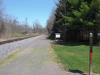
The Susquehanna Warrior Trail is a 9.4-mile (15.1 km) rail trail for bicyclists and pedestrians that runs along the west bank of the Susquehanna River in Luzerne County, Pennsylvania. The trail was created in 2005, and opened to the public in 2007. The Susquehanna Warrior Trail has not yet been dedicated. The trail is part of a plan to create a trail network covering all of Luzerne County.

Kinney Run, also known as Kinney's Run, is a tributary of the Susquehanna River in Scott Township and Bloomsburg, Columbia County, Pennsylvania, in the United States. It is approximately 3.1 miles (5.0 km) long. Some of the first settlers to the Kinney Run area arrived in 1769. There are a number of wetlands and one bog, which is called the Espy Bog, in the stream's watershed.


