Fort Necessity National Battlefield

Last updated

Fort Necessity National Battlefield
Fort Necessity 101114.jpg
The reconstructed Fort Necessity
USA Pennsylvania location map.svg
Red pog.svg
Location of Fort Necessity National Battlefield in Pennsylvania
Usa edcp location map.svg
Red pog.svg
Fort Necessity National Battlefield (the United States)
Location Wharton Township, Fayette, Pennsylvania, United States
Coordinates 39°48′55″N79°35′22″W / 39.81528°N 79.58944°W / 39.81528; -79.58944
Area902.8 acres (365.4 ha) [2]
Elevation1,955 ft (596 m)
EstablishedMarch 4, 1931 [2]
Website Fort Necessity National Battlefield
Fort Necessity National Battlefield
Nearest cityUniontown
NRHP reference No. 66000664 [3]
Added to NRHPOctober 15, 1966

Fort Necessity National Battlefield is a National Battlefield in Fayette County, Pennsylvania, United States, which preserves the site of the Battle of Fort Necessity. The battle, which took place on July 3, 1754, was an early battle of the French and Indian War, and resulted in the surrender of British colonial forces under Colonel George Washington, to the French and Indians, under Louis Coulon de Villiers.

Contents

The site also includes the Mount Washington Tavern, once one of the inns along the National Road, and in two separate units the grave of British General Edward Braddock, killed in 1755, and the site of the Battle of Jumonville Glen.

Battle of Fort Necessity (1754)

An engraving depicting the evening council of George Washington at Fort Necessity. The Night Council At Fort Necessity from the Darlington Collection of Engravings.PNG
An engraving depicting the evening council of George Washington at Fort Necessity.
Diorama depicting the Battle of Fort Necessity, on display at the Fort Pitt Museum. NPS Diorama Fort Necessity battle.jpg
Diorama depicting the Battle of Fort Necessity, on display at the Fort Pitt Museum.

After returning to the great meadows in northwestern Virginia, and what is now Fayette County, Pennsylvania, George Washington decided it prudent to reinforce his position. Supposedly named by Washington as Fort Necessity or Fort of Necessity, the structure protected a storehouse for supplies such as gunpowder, rum, and flour. The crude palisade they erected was built more to defend supplies in the fort's storehouse from Washington's own men, whom he described as "loose and idle", than as a planned defense against a hostile enemy. The sutler of Washington's force was John Fraser, who earlier had been second-in-command at Fort Prince George. Later he served as chief scout to General Edward Braddock and then chief teamster to the Forbes Expedition.

By June 13, 1754, Washington had under his command 295 colonials and the nominal command of 100 additional regular British army troops from South Carolina. Washington spent the remainder of June 1754 extending the wilderness road further west and down the western slopes of the Allegheny range into the valley of the Monongahela River. He wanted to create a river crossing point roughly 41 mi (66 km) away, near Redstone Creek and Redstone Old Fort.

This was a prehistoric Native American earthwork mound on a bluff overlooking the river crossing. The aboriginal mound structure may have once been part of a fortification. Five years later in the war, Fort Burd was constructed at Redstone Old Fort. The area eventually became the site of Nemacolin Castle and Brownsville, Pennsylvania an important western jumping-off point for travelers crossing the Alleghenies in the late 18th and early 19th centuries.

To reach the Ohio River basins' navigable waters as soon as possible on the Monongahela River, Washington chose to follow Nemacolin's Trail, a Native American trail which had been somewhat improved by colonists, with Nemacolin's help. He preferred this to following the ridge-hopping, high-altitude path traversed by the western part of the route that was later chosen for Braddock's Road. It jogged to the north near the fort and passed over another notch near Confluence, Pennsylvania, into the valley and drainage basin of the Youghiogheny River. The Redstone destination at the terminus of Nemacolin's Trail was a natural choice for an advanced base. The location was one of the few known good crossing points where both sides of the wide deep river had low accessible banks; steep sides were characteristic of the Monongahela River valley.

Late in the day on July 3, Washington did not know the French situation. Believing his situation was impossible, he accepted surrender terms which allowed the peaceful withdrawal of his forces, which he completed on July 4, 1754. [4] The French subsequently occupied the fort and then burned it. Washington did not speak French, and stated later that if he had known that he was confessing to the "assassination" of Joseph Coulon de Jumonville, he would not have signed the surrender document.

Park formation and structure

During the Great Depression of the 20th century, attempts to preserve the location of Fort Necessity were undertaken. On March 4, 1931, Congress declared the location a National Battlefield Site under management of the War Department. Transferred to the National Park Service in 1933, the park was redesignated a National Battlefield on August 10, 1961. As with all historic sites administered by the National Park Service, the battlefield was listed on the National Register of Historic Places on October 15, 1966.

Subsequent archaeological research helped to uncover the majority of the original fort position, shape and design. A replica of the fort was constructed on site in the 1970s. A new visitor center, which also is home to a National Road interpretive center, opened on October 8, 2005. The battlefield and fort are currently being improved; the battlefield itself has seen much vegetation growth, and the general public are asked to stay out of the battlefield grounds. As the remains of the casualties of the battle were never truly recovered, the battlefield is treated as hallowed ground.

Mount Washington Tavern

On a hillside adjacent to the battlefield and within the boundaries of the park is Mount Washington Tavern, a classic example of the many inns once lining the National Road, the United States' first federally funded highway.

The land on which the tavern was built was originally owned by George Washington. In 1770 he purchased the site on which he had commanded his first battle. Around the 1830s, Judge Nathanial Ewing of Uniontown constructed the tavern. James Sampey acquired the tavern in 1840. It was operated by his family until the railroad construction boom caused the National Road to decline in popularity, rendering the inn unprofitable.

In 1855, it was sold to the Fazenbaker family. They used it as a private home for the next 75 years, until the Commonwealth Of Pennsylvania purchased the property in 1932. In 1961 the National Park Service purchased the property from the state, making the building a part of Fort Necessity. The Mount Washington Tavern demonstrates the standard features of an early American tavern, including a simple barroom that served as a gathering place, a more refined parlor that was used for relaxation, and bedrooms in which numerous people would crowd to catch up on sleep.

General Braddock's grave site

The grave of General Edward Braddock. Braddock's Grave.jpg
The grave of General Edward Braddock.
Dedication Plaque BraddocksPlaque.jpg
Dedication Plaque

In a separate unit of the park, lying about one mile (1.6 km) northwest of the battlefield, is the grave of General Edward Braddock. The British commander led a major expedition to the area in 1755 which included the construction of Braddock's Road, a useful but inadequate wilderness road through western Pennsylvania. Braddock was severely wounded in the Battle of the Monongahela as the British advanced toward Fort Duquesne.

He and his forces fled along the wilderness road to a site near Great Meadows. Braddock died on July 13, 1755, and was buried in an elaborate ceremony officiated by George Washington. He was buried under the road in order to hide the location of his grave from the enemy French and Indians. [5] In 1804 Braddock's remains were discovered by men making repairs to the wilderness road.[ citation needed ] A marker was erected in 1913.

See also

Related Research Articles

<span class="mw-page-title-main">Fort Duquesne</span> Colonial fort at the confluence of the Allegheny and Monongahela rivers

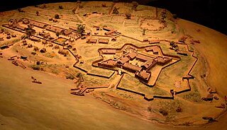
Fort Duquesne was a fort established by the French in 1754, at the confluence of the Allegheny and Monongahela rivers. It was later taken over by the British, and later the Americans, and developed as Pittsburgh in the U.S. state of Pennsylvania. Fort Duquesne was destroyed by the French before its British conquest during the Seven Years' War, known as the French and Indian War on the North American front. The British replaced it, building Fort Pitt between 1759 and 1761. The site of both forts is now occupied by Point State Park, where the outlines of the two forts have been laid in brick.

<span class="mw-page-title-main">Fayette County, Pennsylvania</span> County in Pennsylvania, United States

Fayette County is a county in the Commonwealth of Pennsylvania. It is located in southwestern Pennsylvania, adjacent to Maryland and West Virginia. As of the 2020 census, the population was 128,804. Its county seat is Uniontown. The county was created on September 26, 1783, from part of Westmoreland County and named after the Marquis de Lafayette. The county is part of the Southwest Pennsylvania region of the state.

<span class="mw-page-title-main">Brownsville, Pennsylvania</span> Borough in Pennsylvania, United States

Brownsville is a borough in Fayette County, Pennsylvania, United States, first settled in 1785 as the site of a trading post a few years after the defeat of the Iroquois enabled a resumption of westward migration after the Revolutionary War. The trading post soon became a tavern and inn and was receiving emigrants heading west, as it was located above the cut bank overlooking the first ford that could be reached to those descending from the Allegheny Mountains. Brownsville is located 40 miles (64 km) south of Pittsburgh along the east bank of the Monongahela River.

<span class="mw-page-title-main">Braddock Expedition</span> Military expedition during French and Indian War

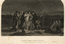
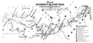
The Braddock expedition, also called Braddock's campaign or Braddock's Defeat, was a British military expedition which attempted to capture Fort Duquesne from the French in the summer of 1755, during the French and Indian War of 1754 to 1763. The British troops suffered defeat at the Battle of the Monongahela on July 9, 1755, and the survivors retreated. The expedition takes its name from General Edward Braddock (1695–1755), who led the British forces and died in the effort. Braddock's defeat was a major setback for the British in the early stages of the war with France; John Mack Faragher characterises it as one of the most disastrous defeats for the British in the 18th century.

<span class="mw-page-title-main">Battle of Fort Necessity</span> Early battle in the French and Indian War

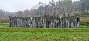
The Battle of Fort Necessity, also known as the Battle of the Great Meadows, took place on July 3, 1754, in present-day Farmington in Fayette County, Pennsylvania. The engagement, along with a May 28 skirmish known as the Battle of Jumonville Glen, was the first military combat experience for George Washington, who was later selected as commander of the Continental Army during the American Revolutionary War by the Second Continental Congress in Philadelphia.

<span class="mw-page-title-main">Joseph Coulon de Jumonville</span>

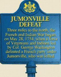
Joseph Coulon de Villiers, Sieur de Jumonville was a French Canadian military officer. His last rank was second ensign. Jumonville's defeat and killing at the Battle of Jumonville Glen by forces led by George Washington was one of the sparks that ignited the Seven Years' War, also known as the French and Indian War in the United States.

<span class="mw-page-title-main">Battle of the Monongahela</span> 1755 battle of the French and Indian War

The Battle of the Monongahela took place on July 9, 1755, at the beginning of the French and Indian War at Braddock's Field in present-day Braddock, Pennsylvania, 10 miles (16 km) east of Pittsburgh. A British force under General Edward Braddock, moving to take Fort Duquesne, was defeated by a force of French and Canadian troops under Captain Daniel Liénard de Beaujeu with its American Indian allies.

Redstone Old Fort — or Redstone Fort or Fort Burd — on the Nemacolin Trail, was the name of the French and Indian War-era wooden fort built in 1759 by Pennsylvania militia colonel James Burd to guard the ancient Indian trail's river ford on a mound overlooking the eastern shore of the Monongahela River in what is now Fayette County, Pennsylvania, near, or on the banks of Dunlap's Creek at the confluence. The site is unlikely to be the same as an earlier fort the French document as Hangard dated to 1754 and which was confusedly, likely located on the nearby stream called Redstone Creek. Red sandstones predominate the deposited rock column of the entire region.

<span class="mw-page-title-main">Battle of Jumonville Glen</span> Opening battle of the French and Indian War

The Battle of Jumonville Glen, also known as the Jumonville affair, was the opening battle of the French and Indian War, fought on May 28, 1754, near present-day Hopwood and Uniontown in Fayette County, Pennsylvania. A company of provincial troops from Virginia under the command of Lieutenant Colonel George Washington, and a small number of Mingo warriors led by the chieftain Tanacharison, ambushed a force of 35 French Canadians under the command of Joseph Coulon de Jumonville.

<span class="mw-page-title-main">Fort Cumberland (Maryland)</span> 18th-century frontier fort at the current site of Cumberland, Maryland

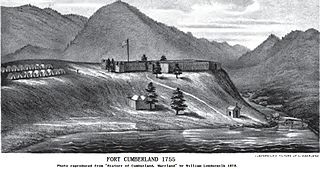
Fort Cumberland was an 18th-century frontier fort at the current site of Cumberland, Maryland, USA. It was an important military and economic center during the French and Indian War (1754–63) and figured significantly in the early career of George Washington.

William Trent was an American fur trader and merchant based in colonial Pennsylvania. He was commissioned as a captain of the Virginia Regiment in the early stages of the French and Indian War, when he served on the western frontier with the young Lt. Colonel George Washington. Trent led an advance group who built forts and improved roads for troop access and defense of the western territory. He was later promoted to the rank of major.

<span class="mw-page-title-main">George Washington in the French and Indian War</span>

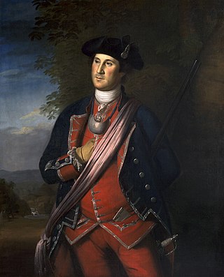
George Washington's military experience began in the French and Indian War with a commission as a major in the militia of the British Province of Virginia. In 1753 Washington was sent as an ambassador from the British crown to the French officials and Indians as far north as present-day Erie, Pennsylvania. The following year he led another expedition to the area to assist in the construction of a fort at present-day Pittsburgh, Pennsylvania. Before reaching that point, he and some of his men, along with Mingo allies led by Tanacharison, ambushed a French scouting party. Its leader was killed, although the exact circumstances of his death were disputed. This peacetime act of aggression is seen as one of the first military steps leading to the global Seven Years' War. The French responded by attacking fortifications Washington erected following the ambush, forcing his surrender. Released on parole, Washington and his troops returned to Virginia.

Braddock's Field is a historic battlefield on the banks of the Monongahela River, at Braddock, Pennsylvania, near the junction of Turtle Creek, about nine miles southeast of the "Forks of the Ohio" in Pittsburgh, Pennsylvania. In 1755, the Battle of the Monongahela was fought on Braddock's Field, which ended the Braddock Expedition.

<span class="mw-page-title-main">Nemacolin's Path</span> Ancient Native American trail

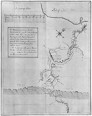
Nemacolin's Trail, or less often Nemacolin's Path, was an ancient Native American trail that crossed the great barrier of the Allegheny Mountains via the Cumberland Narrows Mountain pass, connecting the watersheds of the Potomac River and the Monongahela River in the present-day United States of America. Nemacolin's Trail connected what are now Cumberland, Maryland and Brownsville, Pennsylvania.

<span class="mw-page-title-main">Virginia Regiment</span> Military unit

The Virginia Regiment was formed in 1754 by the Colony of Virginia's Royal Governor Robert Dinwiddie, as a provincial corps. The regiment served in the French and Indian War, with members participating in actions at Jumonville Glen and Fort Necessity in 1754, the Braddock expedition in 1755, and the Forbes expedition in 1758. Small detachments of the regiment were involved in numerous minor actions along Virginia's extensive wilderness frontier.

<span class="mw-page-title-main">Forbes Expedition</span> Military operation during the French and Indian War

The Forbes Expedition was a British military campaign to capture Fort Duquesne, led by Brigadier-General John Forbes in 1758, during the French and Indian War. While advancing to the fort, the expedition built the Forbes Road. The Treaty of Easton served to cause a loss of Native American support for the French, resulting in the French destroying the fort before the expedition could arrive on November 24.

Redstone Creek is a historically important widemouthed canoe and river boat-navigable brook-sized tributary stream of the Monongahela River in Fayette County, Pennsylvania. The creek is 28.4 miles (45.7 km) long, running from headwaters on Chestnut Ridge north through the city of Uniontown and reaching the Monongahela at Brownsville. Located in a 1/4-mile-wide valley with low streambanks, the site was ideal for ship building in a region geologically most often characterized by steep-plunging relatively inaccessible banks — wide enough to launch and float several large boats, and indeed steamboats after 1811, and slow-moving enough to provide good docks and parking places while craft were outfitting.

Thomas Brown, was an American colonial era husbandman, businessman, and land speculator. Along with his brother Basil, he acquired the bulk of the (Brownsville) lands towards the end of the American Revolution from Thomas Cresap(Cresap's War, Lord Dunmore's War), early enough to sell plots to Jacob Bowman in 1780 and Jacob Yoder who respectively made business firsts in 1780 and 1782; Jacob Bowman founded a trading post and tavern. Yoder got in a crop big enough to ship to New Orleans and invented the flat boat on Redstone Creek, inaugurating the water craft construction businesses which made the town an industrial powerhouse for the next seventy years.

John Fraser was a fur trader licensed by the Province of Pennsylvania for its western frontier, an interpreter with Native Americans, a gunsmith, a guide and lieutenant in the British army, and a land speculator. He served in several British campaigns against the French and their allies in the vicinity of Fort Duquesne. Later in life he became a prominent landowner and was appointed justice of the peace, serving on the court until his death in 1773.

Nemacolin was a hereditary chief of the Delaware Nation who helped Thomas Cresap widen a Native American path across the Allegheny Mountains to the Ohio River Valley.

References

Citations

  1. "Fort Necessity National Battlefield". Protected Planet. IUCN. Retrieved May 6, 2018.
  2. 1 2 "Home Page for the Stewardship and Partnerships Team". National Park Service; Philadelphia Support Office. Retrieved June 30, 2009.
  3. "National Register Information System". National Register of Historic Places . National Park Service. July 9, 2010. Retrieved July 16, 2013.
  4. Leckie, 276
  5. Fort Necessity – National Park Service

General and cited references