List of Pennsylvania state forest wild areas

Last updated

Wykoff Run in Quehanna Wild Area, the largest such protected area in Pennsylvania Wykoff Run Swift.jpg
Wykoff Run in Quehanna Wild Area, the largest such protected area in Pennsylvania

The Commonwealth of Pennsylvania in the United States includes 18 wild areas in its State Forest system. [1] They are managed by the Pennsylvania Bureau of Forestry, a division of the Pennsylvania Department of Conservation and Natural Resources.

The Commonwealth describes a wild area as "land where development or disturbance of permanent nature will be prohibited, thereby preserving the wild character of the area" and "an extensive area which the general public will be permitted to see, use and enjoy for such activities as hiking, hunting, fishing, and the pursuit of peace and solitude." [2]

Wild area name   State forest County  Area Date
founded  
Remarks  
Algerine Wild Area Tiadaghton Lycoming 4,177 acres (1,690 ha)Traversed by the Black Forest Trail. [3] [4]
Asaph Wild Area Tioga Tioga 2,070 acres (838 ha) [5]
Burns Run Wild Area Sproul Clinton 2,408 acres (974 ha) [6] Traversed by the Chuck Keiper Trail. [7] [8] [9] [10]
Clear Shade Wild Area Gallitzin Somerset 2,791 acres (1,129 ha)Traversed by the John P. Saylor Trail. [11] [12]
Hammersley Wild Area Susquehannock Clinton, Potter 30,253 acres (12,243 ha)2004Largest area without a road in Pennsylvania. [13] [14]
James C. Nelson Wild Area Tuscarora Juniata, Perry 5,345 acres (2,163 ha)Forest last cut between 1902 and 1917. [15]
Kettle Creek Wild Area Loyalsock Sullivan 2,600 acres (1,100 ha) [16] [17] [18] [19]
Martin Hill Wild Area Buchanan Bedford 11,676 acres (4,725 ha) [20]
McIntyre Wild Area Loyalsock Lycoming 7,500 acres (3,035 ha)Includes remnants of a ghost town. [19] [21]
Penns Creek Wild Area Bald Eagle Mifflin, Union 6,200 acres (2,509 ha)2016 [22]
Quebec Run Wild Area Forbes Fayette 7,441 acres (3,011 ha)2004 [23]
Quehanna Wild Area Elk and Moshannon Cameron, Clearfield, Elk 50,000 acres (20,234 ha)1966Largest Wild Area in Pennsylvania. [24] [25] [26]
Russell P. Letterman Wild Area Sproul Clinton 4,715 acres (1,908 ha) [6] Traversed by the Chuck Keiper Trail. [8] [9] [10]
Square Timber Wild Area Elk Cameron 8,461 acres (3,424 ha) [26]
Stairway Wild Area Delaware Pike 2,882 acres (1,166 ha) [27] [28]
Thickhead Mountain Wild Area Rothrock Centre, Huntingdon 4,886 acres (1,977 ha) [29] [30]
Trough Creek Wild Area Rothrock Huntingdon 1,703 acres (689 ha) [30]
Wolf Run Wild Area Tiadaghton Lycoming 6,900 acres (2,792 ha)Traversed by the Golden Eagle Trail. [3] [4]

Related Research Articles

<span class="mw-page-title-main">Worlds End State Park</span> Park in Sullivan County, Pennsylvania

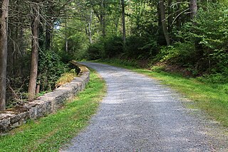
Worlds End State Park is a 780-acre (316 ha) Pennsylvania state park in Sullivan County, Pennsylvania. The park, nearly surrounded by Loyalsock State Forest, is in the Loyalsock Creek valley on Pennsylvania Route 154 in Forks and Shrewsbury Townships southeast of the borough of Forksville. The name Worlds End has been used since at least 1872, but its origins are uncertain. Although it was founded as Worlds End State Forest Park by Governor Gifford Pinchot in 1932, the park was officially known as Whirls End State Forest Park from 1936 to 1943.

<span class="mw-page-title-main">Rothrock State Forest</span> State forest in Pennsylvania, United States

Rothrock State Forest is a Pennsylvania state forest in Pennsylvania Bureau of Forestry District #5. The main offices are located in Huntingdon in Huntingdon County, Pennsylvania in the United States.

<span class="mw-page-title-main">Bald Eagle State Forest</span> State forest in Pennsylvania, United States

Bald Eagle State Forest is a Pennsylvania state forest in Pennsylvania Bureau of Forestry District #7. The main office is located in Laurelton in Union County, Pennsylvania. The forest is found in Centre, Clinton, Mifflin, Snyder, and Union Counties. Bald Eagle shares a common border on its western extent with Rothrock State Forest and on its northern extent with Tiadaghton State Forest.

Tuscarora State Forest is a Pennsylvania state forest in Pennsylvania Bureau of Forestry District #3. The main office is located in Blain in Perry County, Pennsylvania in the United States.

<span class="mw-page-title-main">Moshannon State Forest</span> State forest in Pennsylvania, United States

Moshannon State Forest is a Pennsylvania State Forest in Pennsylvania Bureau of Forestry District #9. The main offices are located in the unincorporated village of Penfield in Huston Township, Clearfield County, Pennsylvania in the United States.

<span class="mw-page-title-main">Susquehannock State Forest</span> State forest in Pennsylvania, United States

Susquehannock State Forest is a Pennsylvania state forest in Pennsylvania Bureau of Forestry District #15. The main office is located in Coudersport in Potter County, Pennsylvania in the United States.

<span class="mw-page-title-main">Tiadaghton State Forest</span> State forest in Pennsylvania, United States

Tiadaghton State Forest is a Pennsylvania State Forest in the Pennsylvania Department of Conservation and Natural Resources, Bureau of Forestry. The forest is primarily in western and southern Lycoming County, with small portions in Clinton, Potter, Tioga, and Union Counties. The district's topography consists of narrow, flat to sloping plateaus cut by deep, steep-sloped valleys carved by fast moving mountain streams, including Pine Creek, Slate Run, and their tributaries. The Tiadaghton district extends south across the lowland along the west branch of the Susquehanna River to the narrow crests of Bald Eagle Mountain and North and South White Deer Ridge. The majority of forest cover is dominated by mixed oak forests, with some areas of northern hardwoods. The Tiadaghton State Forest is one of eight forest districts in the Pennsylvania Wilds region.

<span class="mw-page-title-main">Sproul State Forest</span> State forest in Pennsylvania, United States

Sproul State Forest is a Pennsylvania state forest in Pennsylvania Bureau of Forestry District #10. The main offices are located in Renovo, Pennsylvania in Clinton County in the United States.

<span class="mw-page-title-main">Tioga State Forest</span> State forest in Pennsylvania, United States

Tioga State Forest is a Pennsylvania State Forest in District #16, in the Allegheny Plateau region within Tioga County, Pennsylvania.

Wyoming State Forest was the name of the Pennsylvania State Forest in Pennsylvania Bureau of Forestry District #20. As of July 1, 2005, a reorganization of Pennsylvania State Forests in eastern Pennsylvania resulted in the elimination of the name "Wyoming State Forest". The District #20 main office was located in Bloomsburg in Columbia County, Pennsylvania in the United States.

<span class="mw-page-title-main">Pinchot State Forest</span> State forest in Pennsylvania, United States

Pinchot State Forest is a Pennsylvania State Forest in Pennsylvania Bureau of Forestry District #11. The main offices are located in Lackawanna State Park in North Abington Township in Lackawanna County, Pennsylvania, in the United States.

<span class="mw-page-title-main">Weiser State Forest</span> State forest in Pennsylvania, United States

Weiser State Forest is a Pennsylvania State Forest in Pennsylvania Bureau of Forestry District #18. The main offices are located in Cressona in Schuylkill County, Pennsylvania in the United States.

<span class="mw-page-title-main">Loyalsock State Forest</span> State forest in Pennsylvania, United States

Loyalsock State Forest is a Pennsylvania state forest in Pennsylvania Bureau of Forestry District #20. The forest spans across the northern tier's "Endless Mountains" and is a total of 114,552 acres (46,358 ha). The Loyalsock is a “working forest” and is managed for pure water, recreation, plant and animal habitats, sustainable timber, and natural gas.

<span class="mw-page-title-main">Upper Pine Bottom State Park</span> State park in Lycoming County, Pennsylvania, United States

Upper Pine Bottom State Park is a 5-acre (2.0 ha) Pennsylvania state park in Lycoming County, Pennsylvania in the United States. The park is in Cummings Township on Pennsylvania Route 44 and is surrounded by the Tiadaghton State Forest. It is on Upper Pine Bottom Run, which gave the park its name and is a tributary of Pine Creek. Upper Pine Bottom State Park is in the Pine Creek Gorge, where the streams have cut through five major rock formations from the Devonian and Carboniferous periods.

<span class="mw-page-title-main">Colton Point State Park</span> State park in Pennsylvania, US

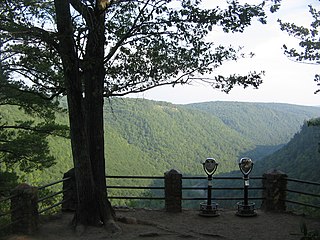
Colton Point State Park is a 368-acre (149 ha) Pennsylvania state park in Tioga County, Pennsylvania, in the United States. It is on the west side of the Pine Creek Gorge, also known as the Grand Canyon of Pennsylvania, which is 800 feet (240 m) deep and nearly 4,000 feet (1,200 m) across at this location. The park extends from the creek in the bottom of the gorge up to the rim and across part of the plateau to the west. Colton Point State Park is known for its views of the Pine Creek Gorge, and offers opportunities for picnicking, hiking, fishing and hunting, whitewater boating, and camping. Colton Point is surrounded by Tioga State Forest and its sister park, Leonard Harrison State Park, on the east rim. The park is on a state forest road in Shippen Township 5 miles (8 km) south of U.S. Route 6.

<span class="mw-page-title-main">Leonard Harrison State Park</span> Park in Pennsylvania, USA

Leonard Harrison State Park is a 585-acre (237 ha) Pennsylvania state park in Tioga County, Pennsylvania, in the United States. It is on the east rim of the Pine Creek Gorge, also known as the Grand Canyon of Pennsylvania, which is 800 feet (240 m) deep and nearly 4,000 feet (1,200 m) across here. It also serves as headquarters for the adjoining Colton Point State Park, its sister park on the west rim of the gorge. Leonard Harrison State Park is known for its views of the Pine Creek Gorge, and offers hiking, fishing and hunting, whitewater boating, and camping. The park is in Shippen and Delmar Townships, 10 miles (16 km) west of Wellsboro at the western terminus of Pennsylvania Route 660.

<span class="mw-page-title-main">Plunketts Creek (Loyalsock Creek tributary)</span> River in the US state of Pennsylvania

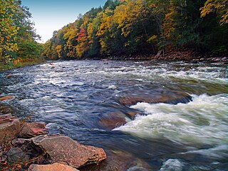
Plunketts Creek is an approximately 6.2-mile-long (10 km) tributary of Loyalsock Creek in Lycoming and Sullivan counties in the U.S. state of Pennsylvania. Two unincorporated villages and a hamlet are on the creek, and its watershed drains 23.6 square miles (61 km2) in parts of five townships. The creek is a part of the Chesapeake Bay drainage basin via Loyalsock Creek and the West Branch Susquehanna and Susquehanna Rivers.

<span class="mw-page-title-main">Hammersley Wild Area</span>

Hammersley Wild Area is a 30,253-acre (12,243 ha) wild area in the Susquehannock State Forest in Potter and Clinton counties in north-central Pennsylvania in the United States. It is the largest area without a road in Pennsylvania and the state's second largest wild area. The wild area is named for Hammersley Fork, a tributary of Kettle Creek, which flows through the area. The wild area includes 10.78 miles (17.35 km) of the Susquehannock Trail System, an 83.4-mile (134.2 km) loop hiking trail almost entirely on state forest land.

References

  1. Klyza, Christopher McGrory (2001). Wilderness comes home: rewilding the Northeast. Hanover, New Hampshire: Middlebury College Press / University Press of New England. p. 86. ISBN   1-58465-101-6.
  2. "Guidelines and Definitions for Natural Areas & Wild Areas". Pennsylvania Department of Conservation and Natural Resources. June 2016. p. 6.
  3. 1 2 "Natural & Wild Areas near the Tiadaghton State Forest". Pennsylvania Department of Conservation and Natural Resources. Archived from the original on March 2, 2004. Retrieved 2010-03-01.
  4. 1 2 "Tiadaghton State Forest Wild and Natural Areas". Pennsylvania Department of Conservation & Natural Resources. Retrieved 2023-12-16.
  5. "Tioga State Forest Wild and Natural Areas". Pennsylvania Department of Conservation & Natural Resources. Retrieved 2023-12-16.
  6. 1 2 "Site #30-Southern Sproul State Forest". Pennsylvania Audubon Society. Retrieved April 2, 2010.
  7. Sproul State Forest (PDF) (Map). 1 inch = 2 miles. Pennsylvania Department of Conservation and Natural Resources. Archived from the original (PDF) on February 18, 2007. Retrieved 2010-03-01.
  8. 1 2 "Proposed Natural/Old-growth Area, Sproul State Forest". Pennsylvania Department of Conservation and Natural Resources. Archived from the original on March 2, 2004. Retrieved 2010-03-01. Note: This refers to Russell P. Letterman Wild Area by its former name, Fish Dam Wild Area
  9. 1 2 "Pennsylvania Wilds: Chuck Keiper Trail". Pennsylvania. Retrieved 2010-03-01. Note: This mistakenly calls Burns Run Wild Area "Burns Wild Area" and refers to Russell P. Letterman Wild Area by its former name, Fish Dam Wild Area.
  10. 1 2 "Sproul State Forest Wild and Natural Areas". Pennsylvania Department of Conservation & Natural Resources. Retrieved 2023-12-16.
  11. John P. Saylor Trail, Pennsylvania Department of Conservation and Natural Resources
  12. "Gallitzin State Forest Wild and Natural Areas". Pennsylvania Department of Conservation & Natural Resources. Retrieved 2023-12-16.
  13. "The Resource: Hammersley Wild Area becomes official". Pennsylvania Department of Conservation and Natural Resources. January 2004. Archived from the original on March 9, 2004. Retrieved 2010-03-01.
  14. "Susquehannock State Forest Wild and Natural Areas". Pennsylvania Department of Conservation & Natural Resources. Retrieved 2023-12-16.
  15. "Tuscarora State Forest Wild and Natural Areas". Pennsylvania Department of Conservation and Natural Resources. Retrieved 2021-07-14.
  16. "Site #42-Wyoming State Forest & World's End State Park". Pennsylvania Audubon Society. Retrieved April 2, 2010.
  17. Loyalsock State Forest (PDF) (Map). 1 inch = 2 miles. Pennsylvania Department of Conservation and Natural Resources. Archived from the original (PDF) on November 16, 2006. Retrieved 2010-03-01.
  18. Thornbloom, Gary. "Kettle Creek Natural and Wild Areas via the Loyalsock Trail" (PDF). Pennsylvania Sierra Club.
  19. 1 2 "Loyalsock State Forest Wild and Natural Areas". Pennsylvania Department of Conservation & Natural Resources. Retrieved 2023-12-16.
  20. "Buchanan State Forest Wild and Natural Areas". Pennsylvania Department of Conservation & Natural Resources. Retrieved 2023-12-16.
  21. "Natural & Wild Areas near Loyalsock State Forest". Pennsylvania Department of Conservation and Natural Resources. Archived from the original on November 16, 2006. Retrieved 2010-03-01.
  22. "Bald Eagle State Forest Wild and Natural Areas". Pennsylvania Department of Conservation & Natural Resources. Retrieved 2023-12-16.
  23. "Forbes State Forest Wild and Natural Areas". Pennsylvania Department of Conservation & Natural Resources. Retrieved 2023-12-16.
  24. "Quehanna Wild Area, Wykoff Run Natural Area". Pennsylvania Department of Conservation and Natural Resources. Archived from the original on March 2, 2004. Retrieved 2010-03-01.
  25. "Natural & Wild Areas near the Elk State Forest". Pennsylvania Department of Conservation and Natural Resources. Archived from the original on March 2, 2004. Retrieved 2010-03-01.
  26. 1 2 "Elk State Forest Wild and Natural Areas". Pennsylvania Department of Conservation & Natural Resources. Retrieved 2023-12-16.
  27. "Delaware State Forest Wild and Natural Areas". Pennsylvania Department of Conservation and Natural Resources. Retrieved 2021-07-14.
  28. "Delaware State Forest Wild and Natural Areas". Pennsylvania Department of Conservation & Natural Resources. Retrieved 2023-12-16.
  29. "Natural & Wild Areas near the Rothrock State Forest". Pennsylvania Department of Conservation and Natural Resources. Archived from the original on February 26, 2004. Retrieved 2010-03-01.
  30. 1 2 "Rothrock State Forest Wild and Natural Areas". Pennsylvania Department of Conservation & Natural Resources. Retrieved 2023-12-16.