Valladolid, Negros Occidental

Last updated
Valladolid
Municipality of Valladolid
Our Lady of Guadalupe Church Valladolid Negros Occ Philippines.jpg
Façade of Nuestra Señora de Guadalupe Church
Flag of Valladolid, Negros Occidental.png
Nickname(s): 
Rice Granary of Negros Occidental; Fruit Basket of Negros Occidental
Motto: 
Ugyon Dolidnon
Ph locator negros occidental valladolid.png
Map of Negros Occidental with Valladolid highlighted
OpenStreetMap
Valladolid, Negros Occidental
Philippines location map (square).svg
Red pog.svg
Valladolid
Location within the Philippines
Coordinates: 10°28′N122°50′E / 10.47°N 122.83°E / 10.47; 122.83
Country Philippines
Region Western Visayas
Province Negros Occidental
District 4th district
Founded 1860
Named for Valladolid, Spain
Barangays 16 (see Barangays)
Government
[1]
  Type Sangguniang Bayan
   Mayor Enrique R. Miravalles
   Vice Mayor Roel P. Yogore
   Representative Juliet Marie D. Ferrer
   Municipal Council
Members
   Electorate 25,275 voters (2022)
Area
[2]
  Total48.03 km2 (18.54 sq mi)
Elevation
4.0 m (13.1 ft)
Highest elevation
23 m (75 ft)
Lowest elevation
0 m (0 ft)
Population
 (2020 census) [3]
  Total39,996
  Density830/km2 (2,200/sq mi)
   Households
10,121
Economy
   Income class 4th municipal income class
   Poverty incidence
10.29
% (2018) [4]
   Revenue 148.4 million (2020)
   Assets 234.8 million (2020)
   Expenditure 128.3 million (2020)
   Liabilities 80.83 million (2020)
Service provider
  ElectricityNegros Occidental Electric Cooperative (NOCECO)
Time zone UTC+8 (PST)
ZIP code
6103
PSGC
IDD : area code +63(0)34
Native languages Hiligaynon
Tagalog
Named after Valladolid, Spain

Valladolid, officially the Municipality of Valladolid, is a 4th class municipality in the province of Negros Occidental, Philippines. According to the 2020 census, it has a population of 39,996 people. [3]

Contents

Known as the "Fruit Basket of Negros Occidental," the municipality celebrates its fiesta every 28 February.

History

The place was first called “Inabuyan” until the Spanish leaders arrived and one of them named the place after his native town Valladolid in Spain. During the Spanish era, Valladolid was considered one of the most prosperous towns of Negros Occidental. The size of the convent and church built by the Recollect Missionaries in 1851 were proofs of this status considering that the church authorities were powerful in running the affairs of the government.

Valladolid was established in 1860. The influx of settlers from the neighboring islands of Guimaras, Panay and Cebu prompted the then Governor Saravia to create an additional town which is now Pulupandan. The settlers made this town a landing area in coming to Negros, brought about by the introduction of sugar which resulted in the economic growth and prosperity of the island. The town is known as the Rice Granary of Negros Occidental with 90 percent of its arable land planted to palay. It produce more than half a million cavans of rice every year. It also produces vegetables, fruits and the diwal ( Pholas orientalis ) also known as the angel wings clam, a seasonal delicacy.

The Aetas were the original inhabitants of Valladolid. They were ultimately forced to move to the uplands when the early settlers and colonizers came to stay. Significant events in the province during the early founding years as well as major upheavals during and after the revolutionary period brought profound changes in the municipality.

By and large, Valladolid has its place in the historical set-up of the province of Negros Occidental socially, spiritually, economically and politically. It is also the bulwark of Filipinistas Aglipayan in Negros. This dominant sect caused the defeat of the fiery Manuel L. Quezon in the hands of the Aglipayans in the presidential election of 1935 during the Commonwealth era.

Pasundayag Festival is a thanksgiving and celebration of good harvest. It is a farmers festival in honor of the town's patroness, Nuestra Señora de Guadalupe featuring street dancing competition, arena festival dance showdown and merry making.

In 1957, Sitio Paloma was converted into a barrio. [5]

Geography

Along the coastal road of the town of Valladolid Valladolid, Negros Occidental.jpg
Along the coastal road of the town of Valladolid

Valladolid is located on the south-western coast of the Province of Negros Occidental. It is 29 kilometres (18 mi) south of Bacolod.

Valladolid is bounded on the north by the town of Pulupandan, on the south by the municipality of San Enrique, on the west by the Guimaras Strait, and on the east by the city of La Carlota. The global location of Municipality of Valladolid is 10 degrees, 27 minutes 54 seconds - north and 122 degrees 49 minutes 33.6 seconds - east with Our Lady of Guadalupe Church as the benchmark.

Valladolid has two pronounced seasons, wet and dry. The rainy season starts from May to January of the following year with heavy rains occurring during the months of August and September. Dry season starts from the month of February until the last week of April.

Barangays

Valladolid is geographically subdivided into 16 barangays. Each barangay consists of puroks and some have sitios.

  • Alijis
  • Ayungon
  • Bagumbayan
  • Batuan
  • Bayabas
  • Central Tabao
  • Doldol
  • Guintorilan
  • Lacaron
  • Mabini
  • Pacol
  • Palaka
  • Paloma
  • Poblacion
  • Sagua Banua
  • Tabao Proper

Climate

Climate data for Valladolid, Negros Occidental
MonthJanFebMarAprMayJunJulAugSepOctNovDecYear
Mean daily maximum °C (°F)30
(86)
31
(88)
32
(90)
33
(91)
32
(90)
30
(86)
29
(84)
29
(84)
29
(84)
29
(84)
30
(86)
30
(86)
30
(87)
Mean daily minimum °C (°F)22
(72)
22
(72)
22
(72)
24
(75)
25
(77)
25
(77)
25
(77)
24
(75)
24
(75)
24
(75)
23
(73)
23
(73)
24
(74)
Average precipitation mm (inches)38
(1.5)
29
(1.1)
55
(2.2)
65
(2.6)
141
(5.6)
210
(8.3)
212
(8.3)
176
(6.9)
180
(7.1)
180
(7.1)
130
(5.1)
70
(2.8)
1,486
(58.6)
Average rainy days9.07.211.113.525.628.428.927.326.927.721.813.8241.2
Source: Meteoblue [6]

Demographics

Population census of Valladolid
YearPop.±% p.a.
1903 10,550    
1918 10,213−0.22%
1939 14,636+1.73%
1948 13,393−0.98%
1960 14,891+0.89%
1970 17,961+1.89%
1975 21,176+3.36%
1980 21,728+0.52%
1990 29,742+3.19%
1995 31,380+1.01%
2000 32,576+0.81%
2007 34,895+0.95%
2010 36,416+1.56%
2015 37,833+0.73%
2020 39,996+1.10%
Source: Philippine Statistics Authority [7] [8] [9] [10]

Religion

The Parish of Saint Mary of Guadalupe of the Philippine Independent Church. IFI-Church-Valladolid-NegOcc.jpg
The Parish of Saint Mary of Guadalupe of the Philippine Independent Church.

Economy

Major industries

Major products

Education

Primary Level

Public

  • Alijis Elementary school
  • Ayungon Elementary School
  • Batuan Elementary School
  • Emilio Infante Elementary School
  • Ma. Palacios Presbitero Elementary School
  • Pacol Elementary School
  • Tabao Elementary School
  • Valladolid Elementary School

Private

  • Bethel Baptist Church Kindergarten School
  • Faith Christian School
  • Maranatha Christian Academy
  • Negros New Life In Jesus Christian Academy
  • Our Lady of Guadalupe Kinder School

Secondary Level

Public

  • Tabao National High School
  • Tabao National High School - Lacaron Extension
  • Valladolid National High School
  • Valladolid National High School - Ayungon Extension

Private

  • Francisco Infante Memorial High School Inc.

Infrastructure

Power

Power supply provided by NOCECO with frequent and unpredictable brownouts.

Water supply

Clean and safe water supply provided by Valladolid Water District.

Tourism

Related Research Articles

<span class="mw-page-title-main">Guimaras</span> Province in Western Visayas, Philippines

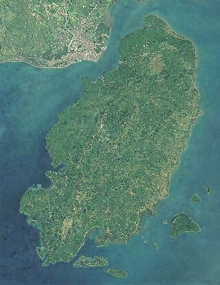
Guimaras, officially the Province of Guimaras, is an island province in the Philippines located in the Western Visayas region. The capital is Jordan, while the largest local government unit for it is the municipality of Buenavista. The province is situated in Panay Gulf, between the islands of Panay and Negros. To the northwest is the province of Iloilo and to the southeast is Negros Occidental. The whole island is part of the Metro IloiloGuimaras, one of the twelve metropolitan areas of the Philippines.

<span class="mw-page-title-main">Western Visayas</span> Administrative region of the Philippines

Western Visayas is an administrative region in the Philippines, numerically designated as Region VI. It consists of six provinces and two highly urbanized cities. The regional center is Iloilo City. The region is dominated by the native speakers of four Visayan languages: Hiligaynon, Kinaray-a, Aklanon and Capiznon. The land area of the region is 20,794.18 km2 (8,028.68 sq mi), and with a population of 7,954,723 inhabitants, it is the second most populous region in the Visayas after Central Visayas.

<span class="mw-page-title-main">Buenavista, Guimaras</span> Municipality in Guimaras, Philippines

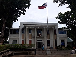
Buenavista, officially the Municipality of Buenavista, is a 2nd class municipality and the largest settlement in the province of Guimaras, Philippines. According to the 2020 census, it has a population of 52,899 people.

<span class="mw-page-title-main">Bacong</span> Municipality in Negros Oriental, Philippines

Bacong, officially the Municipality of Bacong, is a 4th class municipality in the province of Negros Oriental, Philippines. According to the 2020 census, it has a population of 41,207 people.

<span class="mw-page-title-main">Basay, Negros Oriental</span> Municipality in Negros Oriental, Philippines

Basay, officially the Municipality of Basay, is a 4th class municipality in the province of Negros Oriental, Philippines. According to the 2020 census, it has a population of 28,531 people.

<span class="mw-page-title-main">Mabinay</span> Municipality in Negros Oriental, Philippines

Mabinay, officially the Municipality of Mabinay, is a 1st class municipality in the province of Negros Oriental, Philippines. According to the 2020 census, it has a population of 82,953 people, making it the most-populous municipality in Negros Oriental.

<span class="mw-page-title-main">Santa Catalina, Negros Oriental</span> Municipality in Negros Oriental, Philippines

Santa Catalina, officially the Municipality of Santa Catalina, is a 1st class municipality in the province of Negros Oriental, Philippines. According to the 2020 census, it has a population of 77,501 people.

<span class="mw-page-title-main">Sibulan</span> Municipality in Negros Oriental, Philippines

Sibulan, officially the Municipality of Sibulan, is a second class municipality in the province of Negros Oriental, Philippines. According to the 2020 census, it has a population of 64,343 people.

<span class="mw-page-title-main">Alegria, Cebu</span> Municipality in Cebu, Philippines

Alegria, officially the Municipality of Alegria, is a 4th class municipality in the province of Cebu, Philippines. According to the 2020 census, it has a population of 25,620 people.

<span class="mw-page-title-main">Larena</span> Municipality in Siquijor, Philippines

Larena, officially the Municipality of Larena, is a 5th class municipality in the province of Siquijor, Philippines. According to the 2020 census, it has a population of 14,454 people.

<span class="mw-page-title-main">Bago, Negros Occidental</span> Component city in Negros Occidental, Philippines

Bago, officially the City of Bago, is a 2nd class component city in the province of Negros Occidental, Philippines. According to the 2020 census, it has a population of 191,210 people.

<span class="mw-page-title-main">Escalante, Negros Occidental</span> Component city in Negros Occidental, Philippines

Escalante, officially the City of Escalante, is a 4th class component city in the province of Negros Occidental, Philippines. According to the 2020 census, it has a population of 96,159 people.

<span class="mw-page-title-main">Hinigaran</span> Municipality in Negros Occidental, Philippines

Hinigaran, officially the Municipality of Hinigaran, is a 1st class municipality in the province of Negros Occidental, Philippines. According to the 2020 census, it has a population of 88,909 people.

<span class="mw-page-title-main">La Carlota, Negros Occidental</span> Component city in Negros Occidental, Philippines

La Carlota, officially the City of La Carlota,, is a 4th class component city in the province of Negros Occidental, Philippines. According to the 2020 census, it has a population of 66,664 people. making it the least populous city in the province.

<span class="mw-page-title-main">Pontevedra, Negros Occidental</span> Municipality in Negros Occidental, Philippines

Pontevedra, officially the Municipality of Pontevedra, is a 3rd class municipality in the province of Negros Occidental, Philippines. According to the 2020 census, it has a population of 54,502 people.

<span class="mw-page-title-main">Pulupandan</span> Municipality in Negros Occidental, Philippines

Pulupandan, officially the Municipality of Pulupandan, is a 3rd class municipality in the province of Negros Occidental, Philippines. According to the 2020 census, it has a population of 30,117 people.

<span class="mw-page-title-main">San Enrique, Negros Occidental</span> Municipality in Negros Occidental, Philippines

San Enrique, officially the Municipality of San Enrique, is a 4th class municipality in the province of Negros Occidental, Philippines. According to the 2020 census, it has a population of 24,177 people.

<span class="mw-page-title-main">Victorias</span> Component city in Negros Occidental, Philippines

Victorias, officially the City of Victorias, is a 4th class component city in the province of Negros Occidental, Philippines. According to the 2020 census, it has a population of 90,101 people.

<span class="mw-page-title-main">Batuan, Bohol</span> Municipality in Bohol, Philippines

Batuan, officially the Municipality of Batuan, is a 5th class municipality in the province of Bohol, Philippines. According to the 2020 census, it has a population of 13,845 people.

<span class="mw-page-title-main">Sapian</span> Municipality in Capiz, Philippines

Sapian, officially the Municipality of Sapian, and sometimes spelled Sapi-an, is a 4th class municipality in the province of Capiz, Philippines. According to the 2020 census, it has a population of 26,697 people. It is 27 kilometres (17 mi) from Roxas City, the provincial capital.

References

  1. Municipality of Valladolid | (DILG)
  2. "2015 Census of Population, Report No. 3 – Population, Land Area, and Population Density" (PDF). Philippine Statistics Authority. Quezon City, Philippines. August 2016. ISSN   0117-1453. Archived (PDF) from the original on May 25, 2021. Retrieved July 16, 2021.
  3. 1 2 Census of Population (2020). "Region VI (Western Visayas)". Total Population by Province, City, Municipality and Barangay. Philippine Statistics Authority . Retrieved 8 July 2021.
  4. "PSA Releases the 2018 Municipal and City Level Poverty Estimates". Philippine Statistics Authority. 15 December 2021. Retrieved 22 January 2022.
  5. "An Act Creating the Barrio of Paloma in the Municipality of Valladolid, Province of Negros Occidental". LawPH.com. Retrieved 2011-04-13.
  6. "Valladolid: Average Temperatures and Rainfall". Meteoblue. Retrieved 7 May 2020.
  7. Census of Population (2015). "Region VI (Western Visayas)". Total Population by Province, City, Municipality and Barangay. Philippine Statistics Authority . Retrieved 20 June 2016.
  8. Census of Population and Housing (2010). "Region VI (Western Visayas)" (PDF). Total Population by Province, City, Municipality and Barangay. National Statistics Office . Retrieved 29 June 2016.
  9. Censuses of Population (1903–2007). "Region VI (Western Visayas)". Table 1. Population Enumerated in Various Censuses by Province/Highly Urbanized City: 1903 to 2007. National Statistics Office.{{cite encyclopedia}}: CS1 maint: numeric names: authors list (link)
  10. "Province of". Municipality Population Data. Local Water Utilities Administration Research Division. Retrieved 17 December 2016.
  11. "Poverty incidence (PI):". Philippine Statistics Authority. Retrieved December 28, 2020.
  12. "Estimation of Local Poverty in the Philippines" (PDF). Philippine Statistics Authority. 29 November 2005.
  13. "2003 City and Municipal Level Poverty Estimates" (PDF). Philippine Statistics Authority. 23 March 2009.
  14. "City and Municipal Level Poverty Estimates; 2006 and 2009" (PDF). Philippine Statistics Authority. 3 August 2012.
  15. "2012 Municipal and City Level Poverty Estimates" (PDF). Philippine Statistics Authority. 31 May 2016.
  16. "Municipal and City Level Small Area Poverty Estimates; 2009, 2012 and 2015". Philippine Statistics Authority. 10 July 2019.
  17. "PSA Releases the 2018 Municipal and City Level Poverty Estimates". Philippine Statistics Authority. 15 December 2021. Retrieved 22 January 2022.