
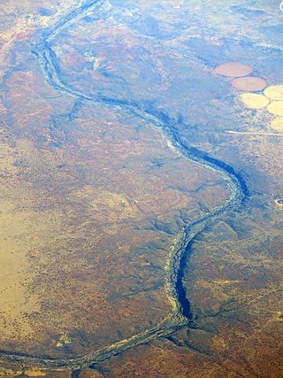
The Orange River is a river in Southern Africa. It is the longest river in South Africa. With a total length of 2,432 km (1,511 mi), the Orange River Basin extends from Lesotho into South Africa and Namibia to the north. It rises in the Drakensberg mountains in Lesotho, flowing westwards through South Africa to the Atlantic Ocean. The river forms part of the international borders between South Africa and Lesotho and between South Africa and Namibia, as well as several provincial borders within South Africa. Except for Upington, it does not pass through any major cities. The Orange River plays an important role in the South African economy by providing water for irrigation and hydroelectric power. The river was named the Orange River in honour of the Dutch ruling family, the House of Orange, by the Dutch explorer Robert Jacob Gordon. Other names include simply the word for river, in Khoekhoegowab orthography written as !Garib, which is rendered in Afrikaans as Gariep River with the intrusion of a velar fricative in place of the alveolar click, Groote River or Senqu River, derived from ǂNū "Black". It is known in isiZulu as isAngqu.

The Vaal River is the largest tributary of the Orange River in South Africa. The river has its source near Breyten in Mpumalanga province, east of Johannesburg and about 30 kilometres (19 mi) north of Ermelo and only about 240 kilometres (150 mi) from the Indian Ocean. It then flows westwards to its confluence with the Orange River southwest of Kimberley in the Northern Cape. It is 1,458 kilometres (906 mi) long, and forms the border between Mpumalanga, Gauteng and North West Province on its north bank, and the Free State on its south.

The Feather River is the principal tributary of the Sacramento River, in the Sacramento Valley of Northern California. The river's main stem is about 73 miles (117 km) long. Its length to its most distant headwater tributary is just over 210 miles (340 km). The main stem Feather River begins in Lake Oroville, where its four long tributary forks join—the South Fork, Middle Fork, North Fork, and West Branch Feather Rivers. These and other tributaries drain part of the northern Sierra Nevada, and the extreme southern Cascades, as well as a small portion of the Sacramento Valley. The total drainage basin is about 6,200 square miles (16,000 km2), with approximately 3,604 square miles (9,330 km2) above Lake Oroville.

The Vaal Dam in South Africa was constructed in 1938 and lies 77 km south of OR Tambo International Airport, Johannesburg. The lake behind the dam wall has a surface area of about 320 square kilometres (120 sq mi) and is 47 meters deep. The Vaal Dam lies on the Vaal River, which is one of South Africa's strongest-flowing rivers. Other rivers flowing into the dam are the Wilge River, Molspruit and Grootspruit. It has over 800 kilometres (500 mi) of shoreline and is South Africa's second biggest dam by area and the fourth largest by volume.

The Molopo River is one of the main rivers in Southern Africa. It has a length of approximately 960 kilometres and a catchment area of 367,201 km2 with Botswana, Namibia and South Africa sharing roughly about a third of the basin each.

Kroonstad, officially named Maokeng, is the fourth largest town in the Free State and lies two hours' drive on the N1 from Gauteng. It is the second-largest commercial and urban centre in the Northern Free State, and an important railway junction on the main line from Cape Town to Johannesburg. Maokeng is Sesotho and means "place of the thorn trees ".

Petrus Steyn, is a small farming town between Tweeling and Kroonstad, 35 km north-east of Lindley in the Free State province of South Africa. It is at the centre of an agricultural area known for wheat, maize, sunflower, potato, cattle, hunting, sheep production and forms part of the breadbasket in the Free State. It is the highest town above sea level in the Free State. In 2012 the town's name was changed to Mamafubedu. Farming industries in Mamafubedu provide potatoes worldwide.

The Olifants River,Lepelle, iBhalule or Obalule is a river in South Africa and Mozambique, a tributary of the Limpopo River. It falls into the Drainage Area B of the Drainage basins of South Africa. The historical area of the Pedi people, Sekhukhuneland, is located between the Olifants River and one of its largest tributaries, the Steelpoort River.

The R82 is a provincial route in South Africa that connects Johannesburg with Kroonstad via Vereeniging and Sasolburg. It starts just south of the M1 Johannesburg Municipal Highway's interchange with the N12 Southern Bypass, going south, meeting the R59, R54, R42 & R28 routes at Vereeniging before crossing the Vaal River into the Free State & proceeding to Kroonstad. It is an alternative, but longer route to the N1 National Route between Johannesburg & Kroonstad.
Mont-aux-Sources is a mountain in Southern Africa, forming one of the highest portions of the Drakensberg Range. It is mostly within Lesotho, with parts in the KwaZulu-Natal and Free State provinces of South Africa.

The Harts River is a northern tributary of the Vaal River, which in turn is the largest tributary of the Orange River. Its source is in the North West Province, but the greater part of its basin is located in the Northern Cape Province, which it enters a few kilometers downstream from the Taung Dam.
The Riet River is a westward-flowing tributary of the Vaal River in central South Africa. In precolonial times the Riet was known as the Gama-!ab, a !Kora name meaning 'muddy'. Its main tributary is the Modder River and after the confluence the Riet River flows westwards to meet the Vaal.
The Sand River is a river in the Free State province, South Africa. It is located close to the towns of Welkom and Virginia in the gold mining centre of the Free State. Its source is located close to Tweefontein NW of Ficksburg not far from the South Africa-Lesotho border. This river is famous because of the historical Sand River Convention signed nearby, an important event in South African political history.
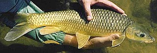
The smallmouth yellowfish is a species of ray-finned fish in the genus Labeobarbus. It has become an invasive species in rivers of the Eastern Cape, South Africa, such as the Mbhashe River.
The Vaal River Barrage Reservoir is a dam on the Vaal River near Vanderbijlpark, border Gauteng and Free State, South Africa.

The Vet River is a westward-flowing tributary of the Vaal River in central South Africa. Its sources are between Marquard and Clocolan and the Vet River flows roughly northwestwards to meet the Vaal at the Bloemhof Dam near Hoopstad.

The Elands River is a northward-flowing tributary of the Wilge River, part of the Vaal River basin, South Africa. Its sources are in the Mont-Aux-Sources.

The Wilge River is a tributary of the Vaal River in central South Africa. This river is important as part of the Tugela-Vaal Water Transfer Scheme where water is transferred from the Tugela River basin to the Vaal River basin.

The Shingwedzi River is a river in Limpopo Province, South Africa, and Gaza Province, Mozambique. It is a left hand tributary of the Olifants River (Rio dos Elefantes) and the northernmost river of its catchment area, joining it at the lower end of its basin. The Shingwedzi is a seasonal river whose riverbed is dry for prolonged periods.
The Mooi River is a river in North West Province, South Africa. It is a tributary of the Vaal River and belongs to the Upper Vaal Water Management Area.

